Видео: Кабо-Верде
Содержание
- Основные моменты
- История Кабо-Верде
- Географические особенности и климат
- Острова Кабо-Верде
- Дайвинг
- Виндсерфинг и кайтсерфинг
- Особенности кухни
- Транспорт
- Виза
- Валюта, чаевые и таможенные особенности
- Сувениры
- Где остановиться
- Как добраться
Основные моменты
На тропических островах популярны дайвинг, прогулки на яхтах, виндсерфинг, кайтсерфинг и спортивная рыбалка. Путешественники, приезжающие в Кабо-Верде ради активного отдыха, предпочитают останавливаться в отелях при дайвинг-центрах и серфинг-станциях или же снимать коттеджи на берегу моря.
На архипелаге живет около 540 тысяч человек. Более 70% местных жителей – мулаты, четверть граждан Кабо-Верде составляют африканцы, а остальные жители являются переселенцами из разных стран Европы. Здесь говорят по-португальски, на креольском диалекте и африканских языках. Благодаря выходцам из западных регионов Африки, у островитян широко распространен французский. Считается, что около 80% населения – католики, а остальные придерживаются местных верований.
На Кабо-Верде родилась известная певица – Сезария Эвора. Босоногая дива прославилась на весь мир исполнением самобытных креольских песен под аккомпанемент гавайской гитары, рояля, аккордеона, кларнета и скрипки. В 2012 году аэропорт на острове Сан-Висенте получил имя талантливой певицы, покорившей сердца любителей музыки в разных уголках планеты.
Вся жизнь тропического архипелага связана с океаном, и туризм составляет основу экономики Кабо-Верде. Развитие туристической инфраструктуры спонсируют местные и зарубежные инвесторы. Особенно много денег в развитие туризма в этой стране вкладывают предприниматели из Австрии, Испании, Германии, Италии, Франции и Португалии. Благодаря им, на островах построены крупные курортные центры, предлагающие своим гостям полный набор необходимых услуг.
История Кабо-Верде
Первые упоминания о Кабо-Верде можно найти у арабских путешественников и географов, живших в XII-XIV веках. Европейцы открыли часть архипелага в 1456 году. Это произошло во время плавания венецианского путешественника Алоизия Када-Мосто, который состоял на службе у португальцев. В последующие годы португальские мореходы побывали на остальных островах. В те времена весь архипелаг покрывала растительность, и здесь не было людей.
Первые европейские поселения появились в Кабо-Верде в 1462 году. Колонисты из Португалии начали осваивать Острова Зеленого Мыса с Сантьягу. Правительство страны поощряло переселенцев большими наделами земли и давало им значительные привилегии в торговле на африканском побережье. Помимо португальцев, острова обживали переселенцы из Испании, Генуи и Франции. А к концу XV века сюда приехали тысячи евреев, которые покинули Европу, желая избежать гонений португальской инквизиции.
Архипелаг располагался на перекрестке торговых судов, курсировавших между Европой, Новым Светом и Африкой, поэтому он быстро превратился в один из центров торговли рабами. Жившие в Кабо-Верде европейцы предприняли несколько экспедиций за «живым товаром» на побережье Гвинеи и во внутренние районы Африки, а рабов вывозили на плантации табака и сахарного тростника, располагавшиеся в Бразилии. Из-за большого притока африканцев, к 1572 году подавляющая часть жителей архипелага были потомками чернокожих рабов, а также мулатов, которые родились от связей африканских женщин с европейцами.
В XVIII-XIX веках Кабо-Верде пострадал от последствий сильной засухи. Неурожаю способствовала постоянная вырубка влажных лесов и расчистка плодородной почвы под пастбища. В результате этого во время трех крупных засух погибло около 100 тысяч местных жителей. Конец работорговли наступил в 1876 году, король Португалии издал специальный декрет, запрещавший рабовладение.
К концу XIX века Кабо-Верде превратился в идеальное место, где дозаправлялись трансатлантические суда. Причаливавшие в Кабо-Верде лайнеры получали на островах необходимый им уголь, питьевую воду, провизию и домашний скот.
В 1951 году Острова Зеленого Мыса, наряду с другими владениями, стали заморской провинцией Португалии. Вскоре возникло движение за независимость Гвинеи и Кабо-Верде, и в 1974 году в столице Португалии было подписано соглашение о признании островов независимой республикой.
Географические особенности и климат
Острова лежат в центре Атлантического океана. Около 16% Кабо-Верде представляет собой каменистые, лишенные растительности нагорья, которые напоминают безжизненные «лунные» пейзажи. Здесь сосредоточено несколько вулканов. Самый крупный из них – Фогу – поднимается на высоту 2829 м.
Острова имеют скалистые обрывистые берега, и существует немного мест, удобных для причаливания судов. Самая большая из гаваней – Порту-Гранде – находится на острове Сан-Висенте. Естественная бухта образовалась в кратере затопленного вулкана. Сегодня вокруг нее раскинулся второй по величине город страны – Минделу.
Кабо-Верде обладает сухим тропическим климатом. Среднегодовая температура воздуха на Островах Зеленого Мыса составляет +25 °С. Самыми холодными месяцами считаются январь и февраль, а самыми жаркими – июль и август. В зависимости от времени года температура океанской воды колеблется от +21 °С до +26 °С.
Дождей выпадает немного – всего 100-300 мм в год. Правда в период дождей, который длится с августа по октябрь, в горах могут пройти сильные ливни, способные нанести большой урон верхнему плодородному слою почвы.
На островах Кабо-Верде круглый год дуют ветра, и, благодаря им, тропическая жара переносится гораздо легче. С середины осени до начала лета преобладает восточный пассат из Сахары, который называют «харматан». Он очень сухой и часто приносит на острова мелкую пыль.
Острова Кабо-Верде
Архипелаг состоит из 10 больших и 5 малых островов, разделенных на «подветренную» и «наветренную» группы. В «наветренную» группу входят Санту-Антан (Santo Antao), Сан-Висенте (San Vicente), Сан-Николау (San Nicolau), необитаемый остров Санта-Лусия (Santa Luzia), Сал (Sal) и Боавишта (Boa Vista). В «подветренную» — Сантьягу (Santiago), Брава (Brava), Фогу (Fogo) и Майу (Maio).
Сал
Самый равнинный из всех островов архипелага славится отличными условиями для любителей дайвинга и серфингистов. Остров имеет вулканическое происхождение и возник из океана около 50 млн лет назад. Он отличается развитой туристической инфраструктурой, поэтому более половины всех путешественников, приезжающих на Кабо-Верде, предпочитают останавливаться именно здесь.
На Сале популярны прогулки на катамаранах и парусниках вдоль побережья. Во время таких морских путешествий туристы могут выкупаться, заняться снорклингом и половить рыбу на удочку. Чтобы путешественники могли лучше увидеть подводный мир и затонувшие корабли, их возят вдоль берега на лодках, имеющих прозрачное дно.
Отдыхая на Сале, интересно совершить визит в городок Санта-Мария и принять ванны в соляных бассейнах. Многие туристы ездят на экскурсию в Oásis de Algodoeiro – к развалинам военной крепости, построенной португальцами во время колонизации острова.
Фогу
Остров-вулкан Фогу – наиболее высокое и одно из самых колоритных мест Кабо-Верде. На этом острове зеленые виноградники соседствуют с безжизненными полями черной лавы, а побережье обрамлено пляжами, которые покрыты темным по цвету вулканическим песком. На Фогу проживают 37 тысяч человек. Местные жители обслуживают туристов, выращивают кофе и производят отличное вино.
Территория вокруг действующего вулкана Фогу объявлена заповедником. В вулканической кальдере находится небольшое селение Шан даш Калдейраш, где живут 1,2 тысячи человек. В этом поселке есть приходская церковь XIX века и небольшой музей «Дом Памяти».
В Сан-Филипе, третьем по величине городе Кабо-Верде, очень много разноцветных домов, которые резко контрастируют с окружающими их горными склонами. Интересно, что почти все здания и церкви этого города построены из вулканического туфа.
Брава
Брава – самый маленький среди других островов Кабо-Верде, благодаря разнообразию редких цветущих растений его часто называют «островом цветов». Он находится в западной части архипелага, в 20 км от Фогу. Даже геологически остров Брава – продолжение Фогу. Глубина моря в канале, который отделяет эти два острова, составляет несколько сотен метров, в то время как основание моря вокруг остальной части острова около 4000 метров глубиной. К северу от Брава лежат два небольших пустынных острова. Туризм тут не развит, из-за крутой береговой линии, которая не позволяет наслаждаться полноценным отдыхом на пляжах острова.
Сантьягу
Самый большой остров архипелага имеет площадь 991 км². На нем проживает большая часть населения Кабо-Верде – свыше 284 тысяч человек. На Сантьягу разместились правительство республики, иностранные посольства и международные организации. За богатую растительность и обилие тропических фруктов остров часто именуют «хлебной корзиной» Кабо-Верде.
Путешественники приезжают на Сантьягу ради прекрасного природного парка, где растут баобабы и драконовые деревья, имеющие возраст более 400 лет. Охраняемая территория находится неподалеку от города Ассамада.
Большой интерес представляет столица острова Прая – город, которой был основан в XV века. Здесь сохранились старые площади, памятники и президентский дворец, построенный в XIX веке. Многие гости города совершают экскурсию в местный этнографический музей.
В 10 км к западу от островной столицы расположен исторический памятник, включенный ЮНЕСКО в список Всемирного наследия. Это крепость Сан-Филипе, которую возвели в конце XVI века, чтобы защитить побережье от пиратов.
Сан-Висенте
Живописный остров протянулся на 24 км и достигает ширины 16 км. Сан-Висенте обладает относительно равнинным рельефом. Высшая точка острова поднимается на 774 м над уровнем моря. На Сан-Висенте открыт Национальный центр ремесел, где поддерживают традиции местного ткачества и изготовления поделок из ракушек и камней.
Столица острова Минделу – второй по величине город республики. Его кварталы выросли на берегу естественной гавани, образованной на краю кратера затопленного вулкана. В Минделу сосредоточено самое большое количество ночных клубов Кабо-Верде. Кроме того, здесь проводятся самые яркие и оживленные карнавалы. Во время августовского полнолуния город встречает красочный фестиваль Баия-даш-Гаташ, а в сентябре – театральный праздник Mindelact.
Боавишта
В переводе с португальского название «Боавишта» означает «прекрасный вид». Это третий по размерам остров Кабо-Верде, в котором живет около 9000 человек. Добраться до Боавишта нетрудно. Из Сала быстроходные катера доходят до острова за час, а на самолете сюда попадают еще быстрее – всего за 15 минут.
Остров Боавишта известен отличными пляжами и живописными дюнами, которые чередуются с зелеными оазисами финиковых пальм. За эти особенности его часто называют островом дюн. В последние годы популярным развлечением стали сафари на внедорожниках, мотоциклах и квадроциклах по пустыне Виана и огромному пляжу Санта-Моника, покрытому мелким белоснежным песком. Величина этой пляжной полосы впечатляет – она протянулась на 40 км.
Сан-Николау
В северной части архипелага находится остров, который долгое время имел статус культурной столицы Кабо-Верде. В 1936 году здесь родилось самобытное литературное течение, и до 1960 года выпускался популярный журнал «Кларидаде».
Остров покрывают горы. Он имеет достаточное количество пресной воды, поэтому здесь развились земледелие и разведение скота. Местной достопримечательностью является скала Ротча Срибидада, где сохранились древние, пока не расшифрованные письмена. По преданию, петроглифы на скале оставили люди, посетившие остров еще до того, как его колонизировали португальцы. Сан-Николау начали заселять в XVII веке, и в его поселках сохранилось немало зданий и церквей XVIII-XIX веков.
Санту-Антан
Второй по площади остров Кабо-Верде охватывает территорию в 779 км². В городе Рибейра-Гранде, столице Санту-Антана, можно увидеть немало построек колониального периода. Здесь же находится самый старый на архипелаге маяк, который возвели в 1886 году.
Путешественники приезжают на Санту-Антан, чтобы совершить трекинги по горным кряжам и полетать на дельтапланах. А поросшие тропической растительностью долины популярны у любителей велосипедных путешествий.
Майу
Майу – тихий уединенный остров, расположенный в крайней восточной части группы островов Кабо-Верде, на расстоянии 25 км от острова Сантьягу. Этот самый старый остров архипелага, который протянулся на 24 км в длину и 16 км в ширину. Кроме того, Майу – древний спящий вулкан, который не просыпается уже в течение нескольких тысяч лет. Остров славится белыми песчаными берегами и лазурным синим морем, однако большинство пляжей находится далеко от главных дорог и добраться туда можно только на внедорожниках или пешком.
Санта-Лусия
Санта-Лусия – единственный необитаемый остров Кабо-Верде. Имеет протяжённость 5 км в ширину и 13 км в длину. Растительности на острове Санта-Лусия мало, но туристы сюда приезжают ради чистых пляжей и дюн. Высочайшая точка на острове 395 м над уровнем моря – это гора Монте-Гранде.
Отсутствие воды сделало невозможными попытки заселить остров постоянными жителями, несмотря на это, с XIX века здесь жили рыболовы и пастухи – всего примерно 20 человек. Известно, что ещё в 1960 году здесь проживала семья пастухов. Однако, начиная с 1990 года государство объявило остров абсолютно необитаемым и присвоило ему статус заповедника.
Дайвинг
Самый популярный вид активного отдыха на Кабо-Верде – это дайвинг. Лучшим временем для погружений считается период с середины весны до конца осени, когда доступны практически все интересные подводные объекты.
Подводный мир Кабо-Верде славится своим многообразием. В чистой и теплой океанской воде обитают тунцы, мурены, барракуды, манты, угри, омары и морские окуни. Здесь можно встретить рыбу-шар, золотых рыбок, стаи королевской макрели, бонито и груперов.
Погружения совершаются на глубину от 6 до 30 м, при этом видимость под водой составляет от 30 до 40 м. Не многие места на планете имеют такие превосходные условия для подводных путешествий! Следует заметить, что здесь нет того изобилия и красочности, ради которого дайверы ездят в Египет. Но по сравнению с Красным морем, вокруг Кабо-Верде гораздо чаще можно увидеть крупных обитателей подводного мира – больших зеленых черепах, трехметровых скатов, стаи резвящихся дельфинов и даже китов.
Кроме разноцветных рыб, крабов, лобстеров и осьминогов, у берегов Кабо-Верде существуют живописные рифы, подводные пещеры, скалы, гроты и затонувшие корабли. Много обломков кораблекрушений лежит на океанском дне возле островов Сантьягу и Маю. Это морские суда, построенные в XV-XVIII веках. Рядом с Салом и Боавиштой старинные суда находятся на доступной глубине в 12-28 м.
На Сале, Санту-Антане, Сан-Висенте и Сантьягу работают крупные дайверские центры, которые предлагают полный спектр услуг – от обучения новичков до аренды снаряжения. Многие дайверы предпочитают останавливаться на этом острове, потому что вокруг него есть более трех десятков интересных дайв-сайтов. Самыми популярными местами острова Сала являются Голубая комната, сайт Palmiera, риф Ponta do Farol, пещера Buracona, а также три сайта, где на глубинах от 9 до 12 м лежат затонувшие корабли.
Виндсерфинг и кайтсерфинг
Любители покататься на волнах под крепким ветром освоили тропический архипелаг достаточно давно. Достаточно сказать, что в Кабо-Верде родился чемпион мира по виндсерфингу в дисциплине фристайл – знаменитый Джош Агуло.
На Кабо-Верде всегда тепло, но не бывает слишком жарко. Вода в океане круглый год обладает комфортной температурой. Ветровой сезон длится с сентября по май. Но лучшим считается период с декабря по апрель, когда средняя скорость ветра достигает 10 м/с. Летом скорость ветра снижается до 7 м/с, и иногда наступают недели полного штиля.
Условия для занятий серфингом благоприятны на всем архипелаге, так как устойчивый бриз с Атлантического океана не обходит ни один из островов. На Сале находится 6 серфинг-центров. На других островах тоже есть серфинг-клубы. Они обладают современным снаряжением, проводят обучение новичков, организуют соревнования и имеют собственные службы спасения.
Больше всего райдеров приезжает на Сал. Самым популярным спотом этого острова признан Понта Прете. Когда свелл идет с западной стороны, здесь образуются самые высокие волны. На этом споте много скал, поэтому его выбирают опытные виндсерферы, способные контролировать ситуацию лучше новичков.
Очень популярна для катания акватория городка Санта-Мария. Береговая набережная островной столицы имеет форму подковы, и в ее центре вода всегда спокойна. Здесь чувствуют себя комфортно начинающие серфингисты. Края бухты, наоборот, вдаются в открытое море, образуя зону жесткого волнового катания. В полукилометре от берега преобладают мощные волны с океана, высота которых часто доходит до 5 м. На востоке городка расположена серф-станция, где работает сам Джош Агуло.
Рядом с Санта-Марией находится несложный спот Альбатрос. На нем дует боковой ветер, благодаря которому образуются простые для катания волны. Однако, следует иметь в виду, что те, кто отходят слишком далеко от берега, рискуют попасть в высокие волны, провалы ветра и сильное течение.
Идеальным местом для кайтсерферов на Сале считают спот Салинас, который расположен всего в нескольких минутах езды от городка Санта-Мария. Это место идеально подходит для новичков, благодаря широкому пляжу, отсутствию сильных прибрежных течений и коралловому рифу. Ветра здесь стабильные и, как правило, дуют с левой стороны.
У приезжающих на Сал новичков популярен и спот Каноа. Он находится в южной части острова, внутри залива Мурдейра. Бухта защищена от сильных ветров, и волны в ней небольшие и безопасные. Она объявлена морским заповедником, так как в брачный сезон сюда приплывают горбатые киты.
Особенности кухни
На Кабо-Верде любят рыбу и морепродукты. Местные повара отлично готовят рыбу-пилу, тунца и морского окуня. В маленьких харчевнях и ресторанах можно всегда заказать блюда из вкусных лобстеров, усоногих раков и осьминогов.
Самым популярным у жителей Кабо-Верде считается «качупа». Ее делают из свинины или другого мяса, фасоли, лука, чеснока, сладкого батата, кукурузы и тыквы. Примечательно, что на каждом острове существуют собственный рецепт этого сытного кушанья. Если в нем используется несколько видов мяса, островитяне называют «качупу» богатой.
На Кабо-Верде прекрасно готовят рис с коктейлем из морепродуктов и мясной суп с креветками. Практически всем путешественникам нравится «джагасида» – блюдо из тушеной свинины и фасоли с заправкой из кукурузной муки. Стоит попробовать также местный деликатес – колбасу «бочада», которую делают из крови и желудка молодых ягнят и подают с рисом. В разных местах Кабо-Верде продают островной фаст-фуд – жареные «дьявольские пироги», для начинки которых используют мясо тунца, спелые помидоры и репчатый лук.
Почти все местные десерты готовят из тропических фруктов. Во многих кафе можно заказать кексы с бананами, печенье из маниоки с медом и нежные творожные пудинги с ярким вкусом папайи или манго.
Кабо-Верде обладает собственными традициями виноделия. На острове Фогу с конца XIX века производят вкусное вино «Кальдерас». Виноградные лозы привез сюда французский граф Монтро. Местные виноградники невелики, и их поливают вручную. Островное вино является предметом экспорта и поставляется в Евросоюз. Лучшим по качеству считается молодое вино, возраст которого еще не достиг одного года. Интересно, что из-за богатой минералами вулканической почвы и теплого тропического климата оно получается на 2 градуса крепче, чем обычное европейское вино.
Отдыхая в Кабо-Верде, стоит попробовать местный тростниковый грог, который островитяне оттеняют различными вкусами фруктов. Слабоалкогольный напиток принято пить горячим и использовать для приготовления коктейлей. Самое большое признание получил грог, произведенный на острове Санту-Антан. Как и вино с Фогу, он тоже идет на экспорт.
Транспорт
Наиболее распространенным видом общественного транспорта в Кабо-Верде являются «aluguer» – маршрутки, которые ходят без четкого расписания. Они отправляются с конечных пунктов, когда в салоне не оказывается свободных мест.
Туристы часто пользуются такси. Если планировать заказ машины на полный день, о цене поездки нужно заранее договариваться с водителем.
От острова до острова курсирует различный транспорт. Отдаленные острова Кабо-Верде связаны самолетами, а близлежащие – паромами и быстроходными катерами.
Виза
Для поездки в Кабо-Верде жителям России необходимо получить визу. Это можно сделать в Москве в консульстве этой страны. Для оформления требуется предъявить загранпаспорт, анкету-заявление, цветное фото 35 на 45 мм, гостиничную бронь (или приглашение от друзей или родственников), а также оплаченные билеты в оба конца либо бронь на билеты.
Документы можно подавать в консульство лично либо по доверенности, причем, не обязательно заверенной нотариально. Туристические визы в Кабо-Верде выдают на полгода. Они бывают однократными, многократными, групповыми (на членов группы от 5 человек) и семейными (для родителя с ребенком). Документы делают в течение 3 дней. Проживать по туристической визе в стране разрешено единовременно в течение 30 дней.
Есть и другой вариант получения визы. Ее можно оформить по прилету в аэропорту на острове Сал. Такая виза стоит дешевле, но для ее оформления, помимо обычного пакета документов, нужно предоставить специальное разрешение, полученное в консульстве республики. Для тех, кто хочет воспользоваться этим вариантом, нужно иметь в виду, что некоторые авиакомпании обслуживают только тех пассажиров, которые имеют заранее оформленное визовое разрешение.
Валюта, чаевые и таможенные особенности
В стране расплачиваются местной валютой – эскудо Кабо-Верде (CVE). Обменивать деньги рекомендуется в банках, потому что в обменных пунктах при аэропортах курс не очень выгодный. Банковские отделения открыты в будние дни с 9.00 до 17.00. Некоторые банки могут работать и по субботам до 12.00.
В стране не делают обратный обмен, поэтому туристам не советуют менять все деньги сразу. Далеко не везде ви Кабо-Верде можно расплатиться с помощью кредитной карточки. Здесь предпочитают наличные деньги.
Если чаевые не включены в сумму счета, в ресторанах принято оставлять 10% от заказа. В остальных местах вопрос о чаевых и их сумме решают сами туристы.
В стране нет никаких ограничений по ввозу и вывозу иностранной валюты, причем любую сумму нет необходимости декларировать. Беспошлинно разрешают ввозить до 2 л алкоголя и 400 сигарет. Особому контролю подлежат ввозимые растения. Из Кабо-Верде можно вывозить до 5 кг овощей и фруктов, а также продукты и вещи, необходимые для личного пользования.
Сувениры
Наиболее распространенными сувенирами, которые путешественники привозят на память о Кабо-Верде, являются выразительные фигурки животных и людей, а также африканские маски, вырезанные из эбенового дерева. Ими торгуют жители Сенегала, и купить такие поделки можно везде. Главное – не забывать торговаться! Кроме того, у туристов популярны сувениры из скорлупы кокосового ореха, бычьих рогов быков и черепашьего панциря, соломенные циновки, шляпки из листьев пальмы рафии, керамические статуэтки и посуда, а также ковровые дорожки и светильники.
На островах продают красивые ювелирные украшения, сделанные из кораллов и жемчуга. Это бусы, серьги, браслеты и серебряные украшения, инкрустированные кусками коралла и отдельными жемчужинами.
Почти все магазины работают с 8.00 до 18.00, кроме воскресенья. Крупные супермаркеты, как правило, открыты до 21.00.
Где остановиться
Кабо-Верде представляет редкое сочетание дикой природы и отличного гостиничного сервиса. Здесь почти нет отелей брендовых марок, но существует много гостиниц, построенных с большим размахом. Крупные курортные комплексы предлагают своим постояльцам уютные номера, рестораны, бары, кафе, поля для гольфа и детские игровые площадки. В большинстве гостиниц есть бассейны так с пресной, так и с соленой водой. Повсеместно распространена система «все включено».
На некоторых островах Кабо-Верде можно снять в аренду коттеджи, стоящие вдали от населенных городов и поселков, прямо на берегу океана. Этот вариант выбирают любители уединенного отдыха. Собственные отели также имеют центры дайвинга и серфинга.
Туристическая инфраструктура создана по всему архипелагу, однако большинство путешественников предпочитает снимать жилье на Сантьягу, Сале, Сан-Николау, Сан-Висенте и Майу. Следует иметь в виду, что не все гостиничные комплексы Кабо-Верде, имеющие 4 и 5 звезд, соответствуют заявленной категории. Доступ в Интернет почти везде предоставляют за отдельную, достаточно высокую плату.
Как добраться
Из России не существует прямых авиарейсов до Кабо-Верде. До аэропортов Сантьягу и Сал можно долететь только с пересадками. Из Москвы самолеты до островов летают через Лиссабон, Мадрид, Париж и Франкфурт. Перелет, без учета времени на пересадку, занимает примерно 9 часов.

КА́БО-ВЕ́РДЕ (Cabo Verde), Республика Кабо-Верде (República de Cabo Verde).
Общие сведения
К.-В. – островное государство близ зап. побережья Африки. Расположено в Атлантическом ок., на о-вах Зелёного Мыса (всего 18, обитаемы 9). Пл. 4033 км2. Нас. 499,4 тыс. чел. (2008). Столица – Прая (на о. Сантьягу). Офиц. язык – португальский. Денежная единица – эскудо. В адм. отношении на обитаемых островах выделяется 17 муниципальных округов (табл.).


К.-В. – чл. ООН (1975), ОАЕ (1975, с 2002 АС), Движения неприсоединения (1975), МВФ (1978), Экономич. сообщества государств Зап. Африки (ЭКОВАС; 1975), Сообщества португалоязычных стран (ПАЛОП; 1996).
Государственный строй
К.-В. – унитарное гос-во. Конституция принята 25.9.1992. Форма правления – парламентарная республика.
Глава государства – президент, избираемый прямыми всеобщими выборами на 5 лет. Кандидат в президенты должен быть гражданином К.-В. старше 35 лет и последние 3 года проживать на родине. Акты президента (декреты) требуют контрасигнатуры премьер-министра.
Административно-территориальное деление (2008)
| Остров | Площадь, км2 | Население, тыс. чел. | Муниципальный округ |
| Боа-Вишта | 620 | 4,6 | Боа-Вишта |
| Илья-Брава | 67 | 6,4 | Брава |
| Маю | 269 | 8,1 | Маю |
| Сал | 216 | 22,5 | Сал |
| Сан-Винсенти | 227 | 79,8 | Сан-Винсенти |
| Сан-Николау | 388 | 12,8 | Сан-Николау |
| Санту-Антан | 779 | 47,2 | Рибейра-Гранди, Паул, Порту-Нову |
| Сантьягу | 991 | 279,5 | Прая, Сан-Домингуш, Санта-Катарина, Санта-Круш, Кальета-де-Сан-Мигель, Таррафал |
| Фогу | 476 | 38,5 | Моштейруш, Сан-Филипи |

Высший орган законодат. власти – однопалатный парламент (Нац. ассамблея). Число депутатов от 66 до 72; они избираются по спискам от политич. партий, объединений по пропорциональной системе на 5 лет.
Исполнит. власть принадлежит правительству, обладающему достаточно широкими полномочиями. Премьер-министр назначается президентом после консультаций с политич. партиями, представленными в парламенте. По предложению премьер-министра президент назначает министров и гос. секретарей. Правительство ответственно перед Нац. ассамблеей. Для оперативного управления внутри правительства создаётся коллегиальный орган – Совет министров. Помимо адм.-управленч. функций, правительство имеет некоторые законодат. полномочия (издаёт законодат. декреты и декреты-законы).
В К.-В. существует многопартийная система. Ведущие политические партии: Афр. партия независимости Кабо-Верде (ПАИКВ), Движение за демократию (ДМД), Партия за демократич. единение (ПДЕ).
Природа
Рельеф
О-ва Зелёного Мыса имеют вулканич. происхождение. Берега преим. крутые и скалистые; удобных гаваней мало, наиболее крупная – Минделу на о. Сан-Висенти (затопленный кратер потухшего вулкана). Для б. ч. островов характерен горный пересечённый рельеф выс. до 2829 м (вулкан Фогу на одноим. острове – высшая точка К.-В.). Острова вост. части (Сал, Боа-Вишта, Маю) отличаются более выровненным рельефом выс. до 436 м. Широко распространены преим. разрушенные вулканич. конусы и кальдеры, лавовые плато.
Геологическое строение и полезные ископаемые

Фото Eraldo DE Gioannini Italy
Искусственно террасированные склоны на острове Санту-Антан.
О-ва Зелёного Мыса представляют собой внутриокеанич. поднятие с увеличенной мощностью океанич. коры, ограниченное с севера крупным трансформным разломом. Сложены неоген-четвертичными лавами и туфами фонолитов, карбонатитов, базальтов, которые перекрывают мезозойские породы цоколя (известняки, местами деформированные флишевые глубоководные отложения, диориты). На островах Маю, Илья-Брава мезозойский цоколь прорван миоценовыми интрузиями (штоками, дайками, кольцевыми телами) щелочных пород. Наземный вулканизм наиболее активно проявился в миоцене – плиоцене. В голоцене были активны вулканы на островах Илья-Брава и Сан-Висенти. На о. Фогу – действующий вулкан (последнее извержение в 1995). На островах Сан-Висенти, Секуш (Ромбу), Ильеу-Бранку распространены голоценовые известняки, пепловые и известняковые пески. В кальдере вулкана на о. Сал – плейстоценовые лагунные отложения, заключающие линзу каменной соли; также известны месторождения природных строит. материалов и сырья для произ-ва строит. материалов (пуццоланы, глины, пески, гипс, известняки).
Климат
Территория принадлежит области тропич. пассатного климата. Ср. темп-ра самого тёплого месяца на побережье (сентябрь – октябрь) 24–26 °С, самого холодного (январь – февраль) 21–22 °С; в горах темп-ры ниже на 3–4 °С. Б. ч. года погода сухая и ясная; в октябре – июне острова подвержены влиянию сухого и жаркого ветра – харматана; в августе – октябре – дождливый сезон. Осадки (до 300 мм в год) неравномерно распределены по годам; часты засухи, в горах случаются сильные ливни, приводящие к смыву почв.
Внутренние воды
На крупных островах развита сеть коротких пересыхающих водотоков. Ежегодно возобновляемые водные ресурсы крайне незначительны (0,3 км3); на каждого жителя страны приходится 634 м3 воды в год. Для хозяйств. нужд используются преим. ресурсы подземных вод. Св. 90% водозабора расходуется на нужды с. х-ва (пл. орошаемых земель 1821 га), 7,3% – на коммунально-бытовое водоснабжение, 1,8% потребляют пром. предприятия.
Почвы, растительный и животный мир
Многовековое и нерациональное с.-х. освоение привело к значит. антропогенному опустыниванию земель. Почвы сильно эродированы, преобладают каменистые и щебнистые разности. Растит. мир небогат, фрагменты ксерофитной древесной и кустарниковой растительности (драконово дерево, сидероксилон) уцелели лишь в труднодоступных горных районах. В результате реализации гос. программ лесовозобновления совр. лесистость достигает 20% (2005), преим. за счёт искусств. посадок (акации, эвкалипты), противоэрозионных кустарниковых насаждений и др.
Животный мир обеднён. Немногочисл. млекопитающие представлены преим. интродуцированными видами (одичавшие особи домашней козы, зелёная мартышка, неск. видов грызунов). Более разнообразна орнитофауна (гнездится св. 40 видов птиц, в т. ч. зеленомысский мягкопёрый тайфунник, фаэтоны); под угрозой исчезновения находятся узкоэндемичные разуанский жаворонок и короткопёрая камышовка. Мн. аборигенные виды рептилий (напр., кабо-вердский гигантский сцинк) вымерли; на некоторых островах известны крупные гнездящиеся популяции редких видов мор. черепах (логгерхед, бисса, оливковая ридлея и др.). Прибрежные воды богаты рыбой (тунец, пеламида, сардинелла и др.). В 2003 создана нац. система охраняемых природных территорий общей пл. ок. 1 тыс. га.
Население
Креолы-кабовердцы составляют 73%; на атлантических языках говорят 24,8% (фульбе – 11,5%, баланте – 9%, манджак – 4,3%). Среди остальных – португальцы (2%) и др.

Панорама города Минделу.
Ср. годовой прирост нас. 0,6% (2007). Рождаемость (24,4 чел. на 1000 жит.) почти в 4 раза превышает смертность (6,5 чел. на 1000 жит.); младенческая смертность 45 на 1000 живорождённых. Показатель фертильности 3,3 ребёнка на 1 женщину. В возрастной структуре населения доля лиц трудоспособного возраста (15–64 года) 56,4%, детей (до 14 лет) – 36,9%, лиц старше 65 лет – 6,7%. Ср. возраст населения 20,2 года. Ср. ожидаемая продолжительность жизни 71 год (мужчины – 67,7; женщины – 74,4 года). На 100 женщин приходится 95 мужчин. Со 2-й пол. 20 в. возрастает миграц. отток населения, в т. ч. из-за участившихся засух. Сальдо миграции отрицательное (–11,8 чел. на 1000 жит.; 2007). По оценкам, в нач. 21 в. за рубежом проживает св. 700 тыс. выходцев из К.-В., в т. ч. 300–350 тыс. чел. – в США, св. 200 тыс. чел. – в европ. странах. Ок. 82% нас. страны сконцентрировано на трёх островах (в т. ч. 56% – на крупнейшем о. Сантьягу). Гор. нас. 22% (2007). Крупные города (тыс. чел.; 2008): Прая 124,7, Минделу 74,6 (о. Сан-Висенти), Санта-Мария 20,1 (о. Сал), Педра-Бадежу 10,0 (о. Сантьягу), Сан-Филипи 8,2 (о. Фогу). Экономич. активное население – ок. 130 тыс. чел. (кон. 20 в.); уровень безработицы 21% (2000).
Религия
По неофиц. данным, ок. 95% населения – христиане. Большинство христианского населения – католики, одновременно являющиеся приверженцами разл. афрохристианских синкретических культов; подавляющее большинство протестантов – приверженцы Назарянской (Назарейской) церкви; имеются немногочисл. общины адвентистов седьмого дня, методистов.
Исторический очерк
Острова Зелёного Мыса впервые упоминаются в дневнике араб. путешественника 12 в. Идриси. Европейцам стали известны в результате экспедиций венецианского мореплавателя А. Кадамосто (1455–56) и португ. путешественников Д. Афонсу, Д. Гомиша и А. Ноли (1455–60). В 1462 на необитаемых до того времени островах появились португ. колонисты, на о. Сантьягу основано первое европ. поселение – Рибейра-Гранди (с 1533 город); с 1466 началось массовое заселение островов португальцами. В 1495 они были объявлены португ. колонией (с 1564 находились под прямым управлением короны). В 16 в. острова часто подвергались нападениям пиратов (в 1585 Рибейра-Гранди разграблен англ. пиратами во главе с Ф. Дрейком). В кон. 15–16 вв. о-ва Зелёного Мыса – крупный региональный центр работорговли, служили также базой для проникновения португальцев на материк; в 1650–1879 административно объединены с португ. Гвинеей (Бисау). В 17–19 вв. на островах получило развитие плантац. хозяйство, культивировались хлопчатник, индиго, кукуруза, с нач. 19 в. – кофе. В 1798 установлено регулярное мор. сообщение с метрополией. С упадком работорговли (окончательно запрещена в 1876) началась массовая эмиграция местного населения в Сенегал, США, Бразилию, Аргентину и др. страны.

А. Кабрал. Почтовая марка ГДР. 1978.
В 1951 О-ва Зелёного Мыса получили статус заморской провинции Португалии. В сер. 20 в. на них развернулось нац.-освободит. движение, тесно связанное с борьбой за независимость португ. Гвинеи (Бисау). В 1956 была создана Афр. партия независимости [с 1960 именовалась Афр. партией независимости Гвинеи и Островов Кабо-Верде (ПАИГК)], её генеральным секретарём стал А. Л. Кабрал. В 1961 жители островов получили португ. гражданство, однако не прекратили борьбу за независимость, которая с 1963 приняла форму партизанской войны. Воен. действия на островах завершились после Апрельской революции 1974 в Португалии. В нояб. 1974 представители ПАИГК и португ. правительства подписали соглашение о предоставлении независимости О-вам Зелёного Мыса.
На выборах в июне 1975 победу одержала ПАИГК, президентом избран А. М. Перейра (р. 17.11.1923). 5.7.1975 была провозглашена независимая Республика К.-В. В том же году она стала членом ООН, установила дипломатич. отношения с СССР. Конституция страны включала статью о будущем объединении К.-В. с Гвинеей-Бисау, устанавливала однопартийный режим. Правительство Перейры приступило к проведению мероприятий, направленных на развитие с. х-ва, была ликвидирована крупная земельная собственность, конфискованы земли лиц, бежавших из страны, началось создание гос. хозяйств и кооперативов. После воен. переворота в Гвинее-Бисау 14.11.1980 ПАИГК раскололась. В янв. 1981 члены её быв. региональной организации в К.-В. создали Афр. партию независимости Кабо-Верде (ПАИКВ). Упоминания об объединении К.-В. с Гвинеей-Бисау были изъяты из конституции.
В 1990 в стране введена многопартийная система. На парламентских выборах в янв. 1991 победу одержала созданная в 1990 партия Движение за демократию (МПД). Президентом стал её представитель А. М. Монтейру (р. 16.2.1944). 25.9.1992 вступила в силу новая Конституция страны, закрепившая многопартийную систему. Правительство Монтейру проводило курс на развитие рыночной экономики, привлечение иностр. инвестиций. На выборах в янв. 2001 ПАИКВ получила в парламенте 40 мест, МПД – 30. Президентом стал кандидат от ПАИКВ П. Пиреш (р. 29.4.1934). В янв. 2006 большинство мест в парламенте вновь завоевала ПАИКВ. В февр. 2006 Пиреш был переизбран на второй срок. Политика правительства Пиреша направлена на дальнейшую либерализацию экономики и борьбу с бедностью.
Хозяйство
Объём ВВП 3,7 млрд. долл. (по паритету покупательной способности; 2007), в расчёте на душу населения 7 тыс. долл. Прирост реального ВВП 7% (2007). Индекс человеческого развития 0,736 (2005; 102-е место среди 177 стран мира).
Экономика страны развита слабо (в т. ч. из-за островного положения К.-В., бедной ресурсной базы, частых и продолжительных засух, в результате которых в 20 в. погибло ок. 200 тыс. чел.), зависит от импорта энергоносителей и продовольствия. Значит. часть валютных поступлений обеспечивают денежные переводы выходцев из К.-В., проживающих за рубежом (ок. 20% ВВП, 2004). Важное значение имеют иностр. инвестиции (ок. 60 млн. долл., 2006) и льготные кредиты.
Экономич. политика направлена на укрепление частного сектора, развитие сферы услуг (в первую очередь иностр. туризма, воздушного и водного транспорта). В кон. 20 в. в гос. собственности находилось ок. 40 предприятий; к 2007 все были приватизированы (за исключением нац. авиакомпании TACV) либо ликвидированы. Контроль за деятельностью частных компаний осуществляют созданные гос. агентства, в т. ч. ARE (2004; в области энерго- и водоснабжения, автомобильных и мор. перевозок), ICTI (2005; услуги телефонной связи) и др.
В структуре ВВП на долю сферы услуг приходится 73,8%, пром-сти – 16,9%, с. х-ва – 9,3% (2007).
Промышленность
Энергетика базируется на импортных энергоносителях (в структуре энергопотребления на нефть и нефтепродукты приходится св. 60%). Произ-во электроэнергии 45 млн. кВт·ч (электростанции на дизельном топливе действуют на обитаемых островах), потребление – 41,9 млн. кВт·ч (2006). Ведётся добыча соли (св. 60 тыс. т в год; на островах Сал и Маю), пуццолана (на о. Санту-Антан), др. природных строит. материалов и керамич. сырья (базальт, известняк, гипс, глина, в т. ч. каолин). Действуют фабрики по обработке декоративного камня, произ-ву стройматериалов (в Прае, а также на островах Маю и Боа-Вишта). Переработка с.-х. сырья; произ-во безалкогольных напитков, пива, рыбной муки и рыбных консервов (Прая; о. Сал), текстильных изделий и обуви (Минделу). Судоремонт (Порту-Гранди в г. Минделу); заводы по опреснению мор. воды. Св. 80% производств. мощностей сосредоточено на островах Сантьягу, Сан-Висенте и Сал.
Сельское хозяйство
Из-за гористого рельефа и неплодородных почв с. х-во малопродуктивно. Более 80% продовольствия импортируется или поступает в виде гуманитарной помощи. Земли с.-х. назначения составляют ок. 11,5% территории страны. С сер. 1990-х гг. в результате засух площади под зерновыми культурами сократились почти на 80% (в нач. 21 в. орошается ок. 3 тыс. га). Сбор (тыс. т; 2005): бобов 5, томатов 4,5, кукурузы 4, батата 4, картофеля 3,5, фасоли 2. Выращивают также кокосовую пальму, сахарный тростник, кофе, бананы, ананасы, манго, арахис, клещевину. Животноводство обеспечивает внутр. потребности в мясных продуктах на 95% (при этом св. 25% нас. употребляет мясо в пищу нерегулярно), в молочных – на 25%. Поголовье (нач. 2000-х гг.; тыс. голов): свиней 640, коз 112, крупного рогатого скота 22. Широко распространено птицеводство (произ-во яиц полностью удовлетворяет спрос).
Важное значение имеет рыболовство (обеспечивает до 5% ВВП). Ежегодный улов рыбы ок. 13 тыс. т (преим. тунец, лобстер); б. ч. морепродуктов экспортируется в страны Европы.
Сфера услуг
Наиболее динамично развивается иностр. туризм. Поток туристов (в осн. из европ. стран) постоянно увеличивается (20 тыс. чел. в 1993; 178 тыс. чел. в 2000; 320 тыс. чел. в 2007). Доходы от туризма превышают 50 млн. долл. (сер. 2000-х гг.). Осн. виды туризма – отдых на песчаных пляжах и спортивно-развлекательный (дайвинг). Гл. районы туризма – острова Сал и Боа-Вишта.
Банковско-кредитная система включает 3 гос. банка (Bank of Cabo Verde – выполняет функции центр. банка, Savings Bank of Cabo Verde, Bank of Rural Credit), 4 коммерч. и 3 офшорных банка, 5 небанковских финансовых институтов. Среди коммерч. банков – Banco Commercial do Atlântico, Caixa Económica de Cabo Verde, Banco Interatlântico – дочерние структуры португ. банков; Banco Caboverdiano de Negocios – первый частный нац. банк (c 2005).
Транспорт
Длина автодорог 1,4 тыс. км, в т. ч. с твёрдым покрытием 932 км (2007). Островное положение страны определило развитие возд. и мор. транспорта. Осн. порты – Порту-Гранди в г. Минделу (принимает б. ч. круизных лайнеров), Прая, Палмейра (о. Сал). Ежегодно порты К.-В. обрабатывают св. 500 тыс. т грузов и принимают ок. 250 тыс. пассажиров. Мор. торговый флот включает 8 судов (всего 13,9 тыс. рег. бр.-т, или 7,7 тыс. т дедвейта; 2007). Имеется 8 аэропортов (на всех островах, кроме о. Илья-Брава), в т. ч. 3 международных: Прая (о. Сантьягу), Рабил (о. Боа-Вишта) и Амилкар Кабрал (о. Сал).
Внешняя торговля
Внешнеторговый оборот 827 млн. долл. (2007), в т. ч. импорт 727 млн. долл., экспорт 100 млн. долл. В товарной структуре экспорта преобладают морепродукты, соль, бананы, арахис. Гл. покупатели – Испания (39,4% стоимости), Португалия (19,3%), Нидерланды (11,3%), Германия (10,9%), Марокко (4,1%). Импортируются в осн. нефтепродукты, продовольствие, машины и оборудование из Португалии (41,2%), Нидерландов (10,6%), Испании (6,5%), Италии (5,5%), Кот-д’Ивуара (5,2%), Бразилии (4,8%).
Здравоохранение. Спорт

Эмблема Олимпийского комитета Кабо-Верде.
В К.-В. на 100 тыс. жит. приходится 249 врачей, 87 лиц ср. мед. персонала, 2 стоматолога, 9 фармацевтов (2004). Общие расходы на здравоохранение составляют 5,2% ВВП (бюджетное финансирование 75,8%, частный сектор 24,2%) (2004). Правовое регулирование системы здравоохранения осуществляется Конституцией (1992), законом о противодействии наркотикам (1993). Система здравоохранения децентрализованная, местные власти отвечают за предоставление мед. помощи (охвачено 80% населения). Осн. причины смерти взрослого населения – сердечно-сосудистые заболевания, злокачественные новообразования (2000).
Олимпийский к-т К.-В. основан в 1989, признан МОК в 1993. Спортсмены К.-В. участвуют в Олимпийских играх с 1996 (Атланта), призовых мест не занимали; марафонец А. Зеферину – участник трёх Олимпийских игр (1996–2004). Наиболее популярные виды спорта – футбол, баскетбол, бокс, водные виды, лёгкая атлетика, худож. гимнастика и др. Нац. федерация футбола (основана в 1982) входит в ФИФА (с 1986); сборная команда К.-В. по футболу – участница Кубка Африки и отборочных матчей чемпионатов мира. Мужская сборная команда по баскетболу в 2007 заняла 3-е место на чемпионате Африки.
Образование. Учреждения науки и культуры
Управление учебными заведениями осуществляет Мин-во образования и культуры. Система школьного образования сложилась под влиянием Португалии. Для детей от 6 до 12 лет введено обязат. бесплатное обучение. Начальная (основная) школа 6-летняя; неполная средняя – 3-летняя; полная средняя (лицей) – 2-летняя, имеет 3 направления (по выбору) – гуманитарное, естественно-научное и техническое. Начальным обучением охвачено 90% уч-ся, средним – 58% (2005). Грамотность населения в возрасте старше 15 лет составляет 81,2% (2004). Осн. науч. учреждения, вузы, библиотеки и музеи находятся в Прае. Действуют также Ин-т инж. и мор. наук (1984) в Сан-Висенти, Педагогич. ин-т в Минделу.
Средства массовой информации
В К.-В. еженедельно выходят правительств. издания «Horizonte» (выпускается с 1975; основано как «Voz di Povo», совр. назв. с 1998), «Boletim Oficial da Republica de Cabo Verde», «Boletim Informativo» (с 1976; тираж 1,5 тыс. экз., издаётся Мин-вом иностр. дел; все – на португ. яз.). Независимые еженедельные издания: «A Semana» (с 1991; 5 тыс. экз., на португ. и англ. языках), «Expresso das Ilhas» (с 2001; на португ. яз.). Информац. агентство – Inforpress (с 1988). Телевидение (на португ. и франц. языках) с 1984, радио (на португ., франц. и креольском языках) с 1975. Теле- и радиовещание осуществляет гос. компания «Rádio e Televisão de Cabo Verde» (RTC).
Литература
Лит-ра К.-В. развивается на креольском и португ. языках со 2-й пол. 19 в. Первая книга на креольском яз. – роман «Горести любви» Ш. да Куньи (1893). В этот период появились близкие к фольклору поэтич. формы – морна, коладейра. Мастер морны кон. 19 – нач. 20 вв. – Э. Тавариш (сб. «Креольская морна», 1931). В прозе 1-й пол. 20 в. доминирует социальная проблематика (романы «Сад Гесперид», 1928, «Дети земли», 1930, П. Кардозу). Креольская поэзия 1960–1970-х гг. проникнута революц. настроениями (сб. «Ночь» К. Дамбара, 1964; стихи К. Куноти). В прозе 2-й пол. 20 в. получает распространение жанр «историй» – коротких сценок с нравоучит. концовкой, высмеивающих человеческие пороки (творчество С. Фрузони). Первый опыт модернизма в креольской лит-ре – роман «Родники» М. Вейги (1985).

Кабо-Верде. Форт Сан-Филипи. 1590.
Первый роман на португ. яз. – «Раб» Ж. А. ди Алмейды (1856). В 1936 был основан ж. «Claridade», в котором работали писатели Б. Лопиш, М. Лопиш, поэт Ж. Барбоза, писавший также на креольском яз. и первым затронувший в своём творчестве проблемы эмиграции. В 1944 сформировалась лит. группа «Сертеза» («Certeza»), с которой связано появление в португалоязычной лит-ре К.-В. общеафриканской тематики и обращение к собственной нац. специфике. В 1950–60-х гг. недовольство творч. интеллигенции обществ. устройством и колониальной системой отразилось в творчестве А. А. Гонсалвиша, в романах «Час отплытия» М. Феррейры, «Голодные» Л. Роману ди Мелу (оба 1962). Характерная тенденция прозы 1970–80-х гг. – расширение тематич. диапазона, стремление выйти за пределы антирасистской направленности (романы «Ордер на арест» Феррейры, 1971; «Чернота» Роману ди Мелу, 1973). В постколониальный период заметно разочарование итогами борьбы за независимость (поэзия К. Фортиша; роман «Спорный остров» Э. Тейшейра ди Созы, 1978). Эти тенденции продолжали развиваться в 1990-е гг. (роман «Мой поэт» Ж. Алмейды, 1990). Значит. явлениями 1990-х гг. стали обращение к бытописательству (сб. повестей и рассказов «Фантастический остров» Алмейды, 1994, и др.), выход первого психологич. детектива (роман «Два брата» Алмейды, 1994).
Изобразительное искусство и архитектура
Традиц. жилище в сельских районах – дома под двускатной крышей из соломы или черепицы, с земляным полом и ставнями на окнах. В 1990-х гг. началось строительство совр. многоэтажных отелей и комфортабельных коттеджей, сочетающихся со старинными особняками колониальных времён. Проф. изобразит. иск-во развивается со 2-й пол. 20 в.; среди художников – Б. Барруш-Гиззи, Д. Ж. Карвалью, Л. Лопиш, Ж. Миранда, М. Фернандиш, М. Фигуэйра и Ч. Фигуэйра. Нар. промыслы представлены гончарством, плетением изделий из соломы, изготовлением сувениров из дерева и скорлупы кокосовых орехов, украшений из керамики, ракушек и рыбьих зубов.

Общие сведения о Кабо-Верде
Официальное название — Республика Кабо-Верде (Republica de Cabo Verde).
Расположена на архипелаге островов Зелёного Мыса. Площадь 4033 км2, численность населения 408,8 тыс. чел. (2002, оценка). Государственные языки — португальский и креольский. Столица — г. Прая (95 тыс. чел., 2001). Государственный праздник — День независимости 5 июля (с 1975). Денежная единица — эшкуду.
Член ок. 40 международных организаций, в т.ч. ООН (с 1975), АС (с 2000).
География Кабо-Верде
Архипелаг островов Зёленого Мыса находится в Атлантическом океане между 14°48 и 17°6 северной широты, 22°36 и 25°18 западной долготы, приблизительно в 500 км к западу от Дакара (Сенегал). Он включает 18 островов. Острова Сал, Боавишта и Маю характеризуются равнинным ландшафтом, тогда как остальные представляют собой горные массивы с яркими признаками вулканического происхождения. Береговая линия полого-песчаная или скалистая, есть несколько удобных для судоходства бухт. Наивысшая точка — вулкан Фогу (2829 м). Рек и болот нет, они перестали существовать в результате вырубки лесов колонистами. На высохших руслах построены дамбы для сбора дождевой воды. Основной источник пресной воды — артезианские скважины. Почвы малоплодородные — песчаные, известняковые. Растительность полупустынного типа бедна, есть небольшие посадки эвкалипта, пальм. Животный мир представлен птицами, пресмыкающимися, насекомыми.
Недра островов бедны. Есть небольшие месторождения поваренной и калийной солей, пуццолана (используется в цементной промышленности). Климат тропический, сухой. При небольшом количестве осадков и среднегодовой температуре +22—26°С часто бывают засухи.
Население Кабо-Верде
С сер. 1980-х гг. население увеличилось на 25%. В 2002 прирост населения составил 0,85% в год. Рождаемость 27,81%, смертность 7,1%, детская смертность — 51,86 чел. на 1000 новорождённых (2002). Средняя продолжительность жизни — 69,52 года (72,91 у женщин, 66,23 у мужчин) (2002). Эмиграция 12,26%. Половозрастная структура (2002): 0—14 лет — 41,9% (86 466 мужчин и 84 918 женщин), 15—64 года — 51,5% (соответственно 100 684 и 109 841), 65 лет и старше — 6,6% (10 363 и 16 488). В городах живет 53,3% населения (2000).
Неграмотно среди взрослых 30%.
Этнический состав населения: 71% населения — мулаты, 28% — африканцы, 1% — европейцы. Языки — португальский, креольский, западноафриканские.
90% населения — католики, протестантов 2,5%. Остальные придерживаются традиционных африканских верований.
История Кабо-Верде
Колонизация португальцами островов Зелёного Мыса началась в 15 в. Постепенно росло число ввозимых африканцев-рабов. Смешение португальцев и африканцев создало креольский этнос. После 2-й мировой войны усилилась антиколониальная борьба. В 1956 возникла Африканская партия независимости, которая в 1960 объединилась с освободительным движением Гвинеи-Бисау в Африканскую партию независимости Гвинеи-Бисау и Кабо-Верде (ПА-ИГК). Её возглавил агроном из Кабо-Верде Амилкар Кабрал. В 1963 она начала вооружённую борьбу на территории Гвинеи-Бисау. В 1973 Кабрал был убит агентами португальской охранки. После апрельской революции 1974 в Португалии метрополия предоставила Кабо-Верде независимость. На первых всеобщих выборах в Национальную народную ассамблею победила ПАИГК, и 5 июля 1975 Кабо-Верде была провозглашена суверенной республикой. Первым президентом стал А. Перейра. Его правительство взяло курс на построение социалистического общества.
В стране была введена однопартийная система, ПАИГК стала правящей партией одновременно в двух государствах — в Кабо-Верде и в Гвинее-Бисау. В 1980 после государственного переворота в Гвинее-Бисау партийная организация Кабо-Верде отделилась от ПАИГК и в январе 1981 была переименована в Партию африканской независимости Кабо-Верде (ПАИКВ). Серьёзные экономические трудности вызвали в кон. 1980-х гг. рост недовольства властью. Под влиянием событий в Восточной Европе усилились требования либерализации экономики и создания многопартийной системы. В 1990 была отменена статья Конституции, закреплявшая монополию ПАИКВ на власть. На парламентских выборах 1991 ПАИКВ потерпела поражение, победу одержало Движение за демократию (МПД).
Правительство МПД взяло курс на создание благоприятных условий для деятельности частного капитала и добилось экономической стабилизации, но не смогло улучшить социальное положение большинства населения. В результате МПД проиграла парламентские и президентские выборы 2001. ПАИКВ вновь получила большинство в парламенте, а её лидер П.Пиреш стал президентом. Пиреш заявил, что его правительство продолжит экономические реформы, но уделит большее внимание социальным проблемам. В 2002 произошёл острый конфликт между правительством и оппозицией по поправкам в бюджет. Оппозиция сочла их антиконституционными и выиграла процесс в Верховном суде.


Государственное устройство и политическая система Кабо-Верде
Кабо-Верде — демократическое унитарное государство с республиканской формой правления. Действует Конституция 1992 с поправками 1995 и 1999. В административном отношении делится на 17 районов — Боа Вишта, Брава, Калета, Маю, Моштериуш, Паул, Прая, Порту Нову, Рибейра Гранде, Сал, Санта Катарина, Санта Круж, Сау Домингуш, Сау Николау, Сау Филипе, Сау Иисенте, Таррафал. Главные города: Прая, Минделу — 64 тыс. чел., Сан-Филипи — 6 тыс. чел.
Высший орган законодательной власти — Национальная ассамблея, состоящая из 72 депутатов, избирается на всеобщих выборах сроком на 5 лет. Высший орган исполнительной власти — правительство, возглавляемое премьер-министром, которого назначает президент по рекомендации Национального собрания. Местные органы исполнительной власти — избираемые населением муниципалитеты. Глава государства — президент (П.Пиреш). Председатель Национального собрания — А.Лима. Премьер-министр — Ж.М.Невеш.
Выдающимся государственным деятелем был Амилкар Кабрал (1924—73), основавший ПАИГК и внёсший огромный вклад в достижение независимости Кабо-Верде и Гвинеи-Бисау.
Политическая система многопартийная. Зарегистрированы 7 партий, наиболее крупные: ПАИКВ, МПД, Демократический альянс за перемены, Партия демократического обновления.
Ведущие организации деловых кругов — торговые палаты Наветренных и Подветренных островов. Влиятельная общественная организация — Национальное объединение трудящихся Кабо-Верде.
Во внутренней политике основными направлениями деятельности правительства являются приватизация госпредприятий, привлечение инвестиций из-за рубежа и социальная поддержка бедных слоёв населения.
Во внешней политике Кабо-Верде отдаёт приоритет развитию отношений с Португалией, португалоговорящими странами Африки, Бразилией. В 1996 она объединилась с ними в Сообщество португалоговорящих стран. Последние годы отмечены укреплением связей с франкофонной Африкой.
Вооружённые силы состоят из армии и береговой охраны. Их численность 1200 чел. Военные расходы (2001) 9,3 млн долл. (1,6% ВВП).
Кабо-Верде имеет дипломатические отношения с РФ (установлены с СССР в 1975).
Экономика Кабо-Верде
Экономика страны ориентирована на сферу услуг — торговлю, воздушный и морской транспорт. В 2001 ВВП составил 550 млн долл.США, т.е. 1250 долл. на душу населения; его прирост составил 3%. Структура ВВП по отраслям: сельское хозяйство 11,5%, промышленность 18,6%, услуги — 69,9% (2000). Структура ВВП по занятости: сельское хозяйство 23%, промышленность 6%, услуги 71%. Безработица 21% (по неофициальным данным, более 50%, 2001). Доходы 44% населения ниже уровня бедности. Инфляция 3,8% (2001).
Наиболее значительные предприятия — судостроительная и судоремонтная верфи, рыбоконсервный и цементный заводы. Кроме того, есть пивной завод, швейные и обувные фабрики, мукомольный комбинат, хлебопекарни и завод стройматериалов. Добывается соль, пуццолан. Производство электроэнергии 133,6 млн кВт-ч.
Под сельское хозяйство занято 10% территории — 39 тыс. га, из них 3 тыс. га орошаемые. Засушливый климат не позволяет добиться самообеспечения продовольствием. Страна производит 10—15% потребляемого продовольствия. Остальное (от 30 тыс. до 80 тыс. т) импортируется или поступает по международным программам борьбы с голодом. Основная сельскохозяйственная культура — кукуруза (сбор в 2000 18,5 тыс. т). Выращиваются также бобовые, маниок, сладкий картофель, овощи, фрукты, сахарный тростник. В животноводстве разводятся крупный рогатый скот, козы, свиньи.
Перспективно развитие рыболовства. В 2001 улов рыбы, омаров и лангустов составил 13 тыс. т, ещё 7 тыс. т тунца было выловлено судами ЕС. Оптимальный улов морепродуктов оценивается в 45 тыс. т.
Длина автодорог — 1100 км, из них 858 км с твёрдым покрытием (2001). 40 судов торгового флота Кабо-Верде осуществляют перевозки внутри архипелага, а также в Западную Африку, Европу и Америку. В последнее десятилетие построено несколько новых портов. Грузооборот портов (2000) — 450 тыс. т. Воздушный транспорт связывает Кабо-Верде со странами Африки, Европы, Северной и Южной Америки. Международный аэропорт на острове Сал способен принимать аэробусы. Национальная авиакомпания ТАКВ осуществляет рейсы в 14 городов Европы, Африки и Америки. Местными авиалиниями связаны все крупные острова. Перевезено (2000) 140 тыс. пассажиров, 20 млн ткм грузов (2000).
Стационарных телефонов 60 935, мобильных — 28 119 (2002). Действуют 15 радиостанций и 1 телестанция. Радиоприёмников 100 тыс., телевизоров 15 тыс. (2002, оценка). Число пользующихся Интернетом 12 тыс. (2002).
Туризм — быстро развивающаяся отрасль. В 2000 страну посетили 83,3 тыс. туристов. Доходы от туризма 40,8 млн долл.
Основные цели экономической и социальной политики определены Национальным планом развития: 1) борьба с бедностью; 2) улучшение системы здравоохранения; 3) улучшение санитарного состояния столицы Прая; 4) экономические реформы, включая приватизацию и привлечение иностранных инвестиций.
Финансовая реформа покончила с монопольным положением центрального банка, правительство раздробило его авуары для учреждения новых коммерческих банков. Четыре португальских банка открыли филиалы в Кабо-Верде.
Бюджет 2000: доходы 112 млн долл., расходы (включая бюджет капиталовложений) 198 млн долл. США. Налоги составляют 72% бюджетных поступлений. Внешний долг 301 млн долл. (2000), внутренний долг ок. 100 млн долл., валютные резервы 45,48 млн долл. США (2001).
Дефицит внешней торговли очень значителен. Экспорт — 23,7 млн долл., импорт — 218 млн долл. США (2001). Основные статьи экспорта: нефтепродукты (реэкспорт), морепродукты, обувь, кожи. Основные статьи импорта: продовольствие, промышленные товары, транспортные средства, нефтепродукты. Платёжный баланс положительный (11 млн долл., 2000) благодаря безвозмездной иностранной помощи, займам и притоку инвестиций.
Наука и культура Кабо-Верде
Система школьного образования включает начальное (4—6 лет) и среднее (9—12 лет). В 2000 начальные школы посещали 98 тыс. учеников, а средние — 33 тыс. В 4 местных вузах учились 1200 и за рубежом — 2500 студентов. Ведётся строительство здания университета. На португальском и креольском языках существует значительная художественная литература. В танцах, песнях, прикладном искусстве (керамика, плетёные изделия) сказывается влияние западноафриканского культурного наследия.
Больше фото Кабо-Верде — перейти
Расскажем про крохотное островное государство Кабо-Верде, более известное как Острова Зеленого мыса. Почитайте, ради чего стоит лететь 9 часов вглубь океана.

Содержание
- Где находятся Острова Зеленого мыса на карте мира
- Погода по месяцам
- Как добраться до Кабо-Верде из Москвы
- Разрешение на въезд
- Пересечение государственной границы
- Валюта Кабо-Верде
- Транспорт
- Пляжи
- Покупки и сувениры
- Развлечения и достопримечательности
- Дайвинг
- Виндсерфинг
- Отзывы туристов о Кабо-Верде
Западноафриканское государство Кабо-Верде (Cabo Verde), получившее в 1975 году независимость от Португалии, до 1986 года называлось Островами Зеленого мыса. Это республика. Её столицей является город Прая (130 тыс. человек), расположенный на острове Сантьягу.
Где находятся Острова Зеленого мыса на карте мира
Этот архипелаг из 8 малых и 10 больших островов интересен для нас тем, что хоть он и находится дальше, нежели соседние европейские острова Мадейра, Азорские или, скажем, Канарские, но отдых здесь в силу очевидных причин гораздо дешевле. А между тем это редкостное сочетание девственной природы и высокого уровня обслуживания.
Сбалансированный климат, постоянная среднегодовая температура воздуха (+25° C), незначительный объем осадков превращают этот уголок планеты в ценный курорт. На каждом острове архипелага царит собственный неповторимый микроклимат.
Здесь отходят от благ цивилизации и знакомятся с морскими обитателями. Эта республика с населением около полумиллиона жителей также слывет всемирным центром спортивной рыбалки.

Погода по месяцам
Климат в этих широтах господствует сухой тропический.
- В июле-августе термометр главным образом показывает +28-31° C.
- В январе-феврале – +23-25° C.
Температура океана соответственно +25-26° C и +21-22° C. Непрерывная ветровая активность помогает лучше переносить зной. Осадки – относительная редкость.
Планируете поездку? Вам сюда!
Мы припасли для вас несколько полезных подарков. Они помогут сэкономить деньги на этапе подготовки к путешествию.
Загляните на эту страницу.
Как добраться до Кабо-Верде из Москвы
Страна находится в центре Атлантики напротив Мавритании и Сенегала. Удаленность от суши примерно 600 километров. Перелетев на самолете компании TAP Portugal из столицы нашей Родины с пересадкой в Лиссабоне, можно приземлиться в Сале (аэропорт им. Амилкара Кабрала) либо главной воздушной гавани Кабо-Верде (аэропорт им. Нельсона Манделы в Прае). Стыковочные рейсы также предлагают Air France (с пересадкой в Париже), Iberia (в Мадриде), Lufthansa (во Франкфурте).
Сколько лететь из Москвы?
Время в воздухе – 9 часов.
Разрешение на въезд
Гражданам бывших республик СССР нужна виза, которую выдают в московском консульстве Кабо-Верде или по прибытии при наличии разрешающего документа. Кроме того, крайне желательно оформить медстраховку, учитывая, что в южных странах стабильно неустойчивая эпидемиологическая обстановка.
Пересечение государственной границы
Иностранную валюту можно перемещать через таможню без декларации и ограничений. Свободно допускается ввозить, например, до 400 сигарет и до 2 л спиртных напитков.
Запрещено иметь при себе оружие без разрешающего документа. Обязателен фитоконтроль. Можно брать с собой туда и назад не более 5 кг свежих овощей и фруктов, а также иных продуктов и товаров в необходимом для бытовых нужд количестве.
Данная страна является оплотом католицизма в Африке, поэтом у исламских фундаменталистов (в отличие от материковых соседей Кабо-Верде) здесь можно не опасаться.
Валюта Кабо-Верде
Принятый в этом государстве дензнак – местное эскудо (CVE); разменная монета – сентаво. Ориентировочный курс на сегодня: 1 CVE = ք0,68 ($1 = 97,24 CVE, €1 = 110,71 CVE).
Как и в России, покупку нацвалюты лучше всего осуществлять в помещении банка, а не через обменный пункт; так и выгодней, и безопасней. А еще совет: не меняйте сразу всю сумму. Кредитно-финансовые учреждения функционируют рабочую неделю с 9 до 17 часов по местному времени, часть филиалов работает по субботам до 12 часов.
Рассчитаться пластиковой карточкой можно в отдельных гостиницах, турбюро, солидных ресторациях и супермаркетах. Причем обслуживаются, зачастую, только карты Visa.
Здесь любят чаевые, подношения, да и вообще взятки. В заведениях общепита в знак благодарности принято оставлять 10% сверх суммы счета, в маленьких харчевнях – «сколько не жалко» (если чаевые уже не добавлены в качестве специальной позиции: бывает и такое).
Интересно: Лучшие курорты на океане
Транспорт
Части архипелага связаны друг с другом посредством воздушного сообщения. Между ближайшими островами курсируют паромы и скоростные суда малого водоизмещения.
Самый демократичный вид трансфера – маршрутные такси. У этих «бусиков» определенный график движения отсутствует, отправляются они по мере заполнения салона.
Поездка на таксомоторе обойдется в €6-10. Такси интуристы нередко нанимают на весь день, предварительно оговаривая таксу. На островах она не фиксированная и может значительно варьироваться в зависимости от рыночной конъюнктуры.

Пляжи
Песчаные полудикие пляжи пока недостаточно обжиты и поэтому малолюдны. Вход на них свободный, даже раскладушки бесплатные: утром обслуга их устанавливает, вечером – собирает.
Полезные ссылки
- Travelata, Level.Travel, OnlineTours — ищите тут самые горящие туры.
- Aviasales — сэкономьте до 30% на покупке авиабилетов.
- Hotellook — бронируйте отели со скидками до 60%.
- Numbeo— посмотрите порядок цен в стране пребывания.
- Cherehapa — возьмите надёжную страховку, чтобы не переживать в пути.
- AirBnb — арендуйте квартиру у местных жителей.
Покупки и сувениры
Из того, что можно увезти на память – поделки из кокоса, рога быка, панциря черепахи, керамические статуэтки, соломенные корзины и шляпы, ковры. К развитым народным промыслам можно отнести резьбу по дереву и кости, которой занимаются преимущественно сенегальцы. Цену за настоящие произведения искусства иногда удается сбить вдвое, и за €10-15 вы можете стать обладателем аккуратного местного шедевра.
Интернет на островах очень медленный и очень дорогой.
Развлечения и достопримечательности
Главным негосударственным праздником здесь считается передвижной февральский карнавал (Карнавальный вторник, Пепельная Среда, Святая Пятница). Это наиболее красочное действо на всем континенте.
Сал, пожалуй, самый посещаемый остров. Если вам интересны горные массивы, поезжайте на Санту-Антау. На Фогу имеется спящий вулкан, извергавшийся в 1995 году. Островом цветов называют коренные жители Браву, и это вполне справедливо. Сантьягу – визитная карточка государства, самый крупный и густонаселенный остров. Второй по развитости – Сан-Висенте; его главный населенный пункт Минделу – культурный центр Кабо-Верде, где организуются интересные и содержательные фестивали.
На Боавиште практикуется обзорная экскурсия на весь световой день. Кроме того, предлагаются поездки на Сан-Висенте, Фогу, Сантьягу. По отзывам посетителей, лучшего развлечения для затерянного в океане архипелага не придумаешь.

Дайвинг
Подводное плавание превращается здесь в доминирующую отрасль активного отдыха. Наиболее благоприятные места для этого – побережья Боавишиты, Сала и Сантьягу. В стране оборудован ряд дайв-центров со специальными элементами для погружений: затонувшими судами, колониями кораллов, таинственными пещерами, служащими прибежищем многочисленным подводным существам. А здешние ныряльщики показывают поистине чудеса дайвинга. Глубина погружения варьируется в пределах 6-30 м.
Лучший период для занятий этим хобби – апрель-ноябрь. В остальное время из-за миграции рыб становится не так интересно.
Дайверов предусмотрительно обязывают страховаться, ведь за тысячи километров от дома может случиться всякое. Также требуют наличие медсправки, разрешающей погружаться на определенную глубину. В общем, с этим здесь строго.
В состав армии Кабо-Верде входит чуть больше тысячи человек. Полицейских — примерно столько же.
Виндсерфинг
В Кабо-Верде отличная роза ветров для занятий парусным спортом. Умеренный, стабильно дующий бриз привлекает сюда целые армии аматоров-серфингистов. Встречаются среди них и россияне, владеющие английским. Они облюбовали Сал, где сейчас функционирует 6 серфинг-центров.
На остальных островах архипелага тренируются англичане (Боавишта), американцы (Сан-Висенте), испанцы (Сантьягу), португальцы (Сан-Николау) и немцы (Майу). Хотя это, по большому счету, условности…
Отзывы туристов о Кабо-Верде
Посмотрите видео Михаила Мысина о его поездке в далекую страну.
Часть 1: дорога и первые впечатления
Часть 2: обзор, рынок, виды
Интересуют горящие туры?
Посмотрите, какие варианты есть на ваши даты. Сайт мониторит предложения от 120 фирм. Есть удобная система для поиска и фильтрации предложений. Все цены окончательные. Перелет и проживание уже включены. Цены начинаются от 6 000 рублей с человека.
Для читателей сайта LHTravel есть полезные советы.
Важный P.S.
Если у вас есть минутка, посмотрите, как продвигается наш переезд в США и адаптация на новом месте.


Как обманывают туристов в Барселоне
Расскажем про способ, которым не брезгуют пользоваться некоторые туристические кафе в Барселоне. Почитайте, чтобы не отдавать деньги жуликам.
Посмотреть

Достопримечательности и развлечения Феодосии
Расскажем, какие интересные места стоит посмотреть во время поездки в Феодосию. Почитайте перед поездкой, чтобы составить маршрут.
Посмотреть

Отдых в апреле на море — куда поехать недорого
Поговорим, куда полететь в апреле к морю. Сделали обзор самых популярных пляжных направлений. Поговорим про погоду, главные развлечения за границей,
Посмотреть

Терракотовая армия китайского императора
В статье расскажем про удивительную археологическую находку в Китае — терракотовую армию императора. Как ее обнаружили и что все это
Посмотреть

Отдых в Адлере в июле
Обсудим, стоит ли ехать в Адлер в середине лета. Не слишком ли жарко? Какая температура воздуха и воды? Куда сходить
Посмотреть

Пляжный отдых на Барбадосе
Любители отдыха на пляжах с белоснежным песком, омываемых лазурными водами, будут в восторге от острова Барбадос с его природной красотой,
Посмотреть
- Природа.
- Население.
- Религии.
- Государственное устройство.
- Судебная система.
- Вооруженные силы.
- Государственный флаг.
- Внешняя политика.
- Экономика.
- Сельское хозяйство.
- Промышленность.
- Внешняя торговля.
- Энергетика.
- Транспорт.
- Финансы и кредит.
- Административное устройство.
- Политические партии.
- Профсоюзные объединения.
- Образование.
- Здравоохранение.
- Пресса, радиовещание, телевидение, Интернет.
- Туризм.
- Архитектура.
- Изобразительное искусство и ремесла.
- Литература.
- Музыка.
- Театр и кино.
- История.
- Колониальный период.
- Период независимого развития.
- Кабо-Верде в 21 веке
КАБО-ВЕРДЕ (Республика Кабо-Верде). Островное государство у западного побережья Африки. Столица – г.Прая (125 тыс. чел., 2009). Территория – 4,033 тыс. кв. км. Административно-территориальное деление – 17 муниципальных округов. Население – 523,568 тыс. чел. (2012). Официальные языки – португальский и креольский (криулу). Религия – христианство и традиционные африканские верования. Денежная единица – эшкуду Кабо-Верде. Национальный праздник – 5 июля – День независимости (1975). Кабо-Верде – член ООН с 1975, Движения неприсоединения, Организации африканского единства (ОАЕ) с 1975, Африканского союза (АС) с 2002, Экономического сообщества государств Западной Африки (ЭКОВАС), Сообщества португалоязычных стран (ПАЛОП) с 1996.
Страна расположена на архипелаге островов Зеленого Мыса в Атлантическом океане на расстоянии ок. 455 км от г.Дакара (Сенегал) – самой западной точки африканского континента. Архипелаг – часть Макронезии (туда входят также Азорские, Канарские, Пустынные острова и о-в Мадейра). Состоит из 18 крупных и мелких островов (Боавишта, Брава, Бранку, Гранди, Душ-Пассаруш, Луиш-Карнейру, Маю, Разу, Сал, Сан-Висенти, Сан-Николау, Санта-Лузия, Санта-Мария, Санту-Антан, Сантьягу, Сападу, Сима и Фогу). Самый большой остров – Сантьягу (991 кв. км).
. Плотность населения – 118 человек на 1 кв. км. Городское население – 50%, сельское – 50%. Площадь – 4033 кв. км. Самая высокая точка – вулкан Фогу (2829 м). Основные языки – португальский (официальный), креольский. Основная религия – католицизм. Административно-территориальное деление – 14 округов. Денежная единица: эскудо = 100 сентаво. Национальный праздник: День независимости – 5 июля. Государственный гимн: «Солнце, пот, зелень и море».")


Природа.
Острова вулканического происхождения. Рельеф преимущественно горного характера. Равнины находятся на о-вах Боавишта, Маю и Сал. Береговая линия островов (1053 км) скалистая и очень изрезана. Архипелаг находится в одной из сейсмических зон Африки, наиболее частые землетрясения на о-ве Брава. Высшая точка архипелага – действующий вулкан Фогу (2829 м), расположенный на одноименном острове (последнее извержение произошло в 1995). Выделяют две группы островов – северные наветренные (Барлавенту) и южные подветренные (Сотавенту). Полезные ископаемые: базальт, вулканический туф, известняк, каолин, пемза, пуццолан и соль. На о-вах Брава и Санту-Антан находятся источники лечебных минеральных вод.
Климат – сухой тропический (жаркий). Самый теплый период года – август-сентябрь, самый прохладный – январь-февраль. Среднегодовая температура воздуха составляет +22–26° С. Среднегодовое количество осадков – 100–300 мм., бoльшая их часть выпадает в горах. Растительность скудная. Флора насчитывает 450 местных видов растений и 150 завезенных. В горах растут акации, бомбардейра, кипарисы, сосны и эвкалипты, в долинах – миндаль, кокосовые и финиковые пальмы. Встречаются баобабы, драконово дерево и манго. Самый зеленый остров архипелага – Брава, иногда его называют островом цветов. Вырубка лесов привела к практическому исчезновению рек, их русла заполняются водой только в период дождей. Источники пресной воды – колодцы, буровые установки и опреснительные установки. Фауна – разнообразный мир птиц (белая цапля, глухари, зимородки, кулики, морские чайки, перепела, попугаи, соколы, фламинго, фрегаты) и много видов ящериц. Большинство видов животных завезены поселенцами – домашний скот, кошки, кролики, крысы, мыши, обезьяны и собаки. Разнообразен мир бабочек и насекомых. Воды островов богаты рыбой (барракуда, кефаль, лосось, макрель, морской язык, мурена, сельдь, тунец). Много акул, лангустов и моллюсков. Встречаются киты и морские черепахи.
Население.
Плотность населения – ок. 130 чел. на 1 кв. км. (2009).
Среднегодовой прирост населения – 1,428%. Уровень рождаемости – 21,21 на 1000 чел., смертность составляет 6,28 на 1000 чел.
Детская смертность – 26,02 на 1000 новорожденных. Средняя продолжительность жизни – 71,8 года (67,78 года у мужчин и 73,27 у женщин). (Все показатели даны по состоянию на 2012).
70% населения – креолы (потомки от смешанных браков португальских и испанских поселенцев с африканцами), 28% – африканцы, 1% – европейцы. Кроме португальского языка, распространен креольский диалект криулу (смесь старопортугальского и африканских языков). 53,3% населения – жители городов и городских поселков (2000). Самый населенный остров – Сантьягу.
Более 60% населения живет в городах. Крупные города: Минделу (62,97 тыс. чел.), Сан-Филипи (6 тыс. чел.) – 2000.
Покупательная способность в 2002 составила 1,4 тыс. долл. США. В 2011 этот показатель составил 2,078 тыс. долл. США. (довольно высокий для африканских стран уровень), тем не менее, ок. 30% населения квалифицируется, как бедное.
Продолжается процесс эмиграции населения. Кабовердеанская диаспора в Италии, Нидерландах, Португалии, США и странах Африки (Анголе, Габоне, Гвинее-Бисау, Сан-Томе и Принсипи, Сенегале и Мозамбике) насчитывает 700 тыс. чел.
Религии.
Одна из самых католических стран Африки. Христианство, распространившееся здесь с середины 17 в., исповедуют ок. 92,5% населения: 90% принадлежат к римско-католической церкви, 2,5% – протестанты (в основном прихожане Церкви Назарета). 7,5% жителей придерживаются традиционных африканских верований, являются членами религиозных сект (свидетели Иеговы, мормоны и др.) или исповедуют ислам.
Государственное устройство.
Парламентская республика. Действует конституция, принятая 25 сентября 1992. Главой государства и главнокомандующим вооруженными силами является президент, избирается на всеобщих выборах на 5-летний срок. Парламент – однопалатная Национальная ассамблея (72 места), депутаты которой избираются на 5 лет.
Судебная система.
В основу заложена юридическая система Португалии.
Вооруженные силы.
Вооруженные силы (1200 чел.: 1000 чел. сухопутных войск, авиация – 100 чел., 100 чел. береговой охраны – 2001) созданы на основе Народных вооруженных революционных сил Гвинеи-Бисау и Кабо-Верде, сформированных в 1967. Воинская служба носит обязательный характер. Внутренний порядок обеспечивают подразделения полиции (ок. 1 тыс. чел.). Военные расходы в 2002 составили 1,6% ВВП.
Государственный флаг.
В 1992 утверждены новые символы (флаг, герб и гимн). Флаг – полотнище из пяти горизонтально расположенных полос. Верхняя и нижняя – голубого цвета, между ними расположены две белые и одна красная (в центре) полосы, на которых по кругу размещены десять желтых пятиконечных звезд.
Внешняя политика.
Наиболее активно внешнеполитические связи развиваются с Германией, Италией, Китаем, Португалией, США, Францией, Японией и португалоязычными странами Африки. Дипломатические отношения между СССР и Кабо-Верде установлены 14 июля 1975. Активно идет сотрудничество в области гражданской авиации. Республика не имеет своего представительства в РФ.
Экономика.
С начала 1990-х приоритетной отраслью стал туризм. Осуществляется приватизация государственных предприятий. Созданы зоны свободной торговли.
Республика – один из крупнейших в мире потребителей иностранной помощи в расчете на душу населения – 270 долл. США. 2/3 помощи предоставляют страны Евросоюза. Успешное развитие индустрии туризма (шестикратное увеличение в 1991–2000 числа мест в туристических комплексах и создание 25 тыс. новых рабочих мест) способствовало сокращению безработицы. Ее уровень в 2000 составил 21%. В 2002 рост ВВП – 4%, инфляции – 3%.
Сельское хозяйство.
Доля аграрного сектора в ВВП составляет 11% (2001). Обрабатываемые земли – 10% территории. Выращивают ананасы, бананы (по качеству считаются одними из лучших в мире), бобовые, капусту, картофель, кассаву, кукурузу, манго, орехи кока, сахарный тростник и томаты. Развитие сельского хозяйства осложняют частые засухи. Животноводство – выращивание коз, крупного рогатого скота, овец, ослов и свиней. Рыболовство развито слабо. С 1990 в водах Кабо-Верде ведут вылов тунца корабли стран ЕС. В 2001 заключено очередное трехлетнее соглашение, по которому квоты на вылов тунца увеличены до 7 тыс. т.
Промышленность.
Развита слабо. Ее доля в ВВП в 2001 составила 17%. Основные предприятия – рыбоконсервные заводы, судоремонтная верфь, пивной завод, швейные и обувные фабрики, завод стройматериалов, фабрики по обработке декоративного камня и заводы по сборке велосипедов и мотоциклов. Горнодобывающая промышленность: добыча соли и пуццолана (используется для производства цемента).
Внешняя торговля.
Объем импорта значительно превышает объем экспорта. Импорт в 2002 – 220 млн. долл. США, экспорт – 30 млн. долл. США. Основу импорта составляют продукты питания, дизельное топливо, машины, транспортное и электрооборудование, бумажная продукция. Основные партнеры по импорту: Португалия (49,1%), Нидерланды (7,2%), Германия (5,7%) – 2002. Экспортируются рыба, лангусты, соль, кожа, обувь и одежда. Основные партнеры по экспорту – Португалия (38,5%), Великобритания (26,4%), Франция (23,1%) и США (8,2%) – 2002.
Энергетика.
100% электроэнергии вырабатывается на тепловых электростанциях, использующих дизельное топливо, дрова и древесный уголь.
Транспорт.
Железнодорожного сообщения нет. Протяженность автодорог – 1100 км, в том числе 858 км асфальтированных (1999). Морские порты: Минделу, Прая и Таррафал. Морской торговый флот – 40 кораблей (2001). В 2002 было 9 аэропортов, в том числе 2 международных – на о.Сал (открыт в 1973) и в г.Прае (открыт в 1999).
Финансы и кредит.
Денежная единица – эшкуду Кабо-Верде (CVE), состоящий из 100 сентаву. Курс национальной валюты в декабре 2002: 1 USD = 123,21 CVE.
Административное устройство.
Страна разделена на 17 муниципальных округов, состоящих из зон.
Политические партии.
Многопартийная система. Наиболее влиятельными являются: «Африканская партия независимости Кабо-Верде», ПАИКВ (Partido Africano da Independência de Cabo Verde, PAICV). Создана в 1956 как «Африканская партия независимости Гвинеи-Бисау и Кабо-Верде» (ПАИГК). Нынешнее название получила в 1981. Ставит целью проведение демократических реформ и сокращение уровня бедности. В 1975–1991 – единственная и правящая партия. С 2001 вновь находится у власти. «Движение за демократию», МПД (Movimento para a Democracia, MPD), лидер – Агустиньо Лопеш (Agostinho Lopes). Создана в 1990. Считает своей задачей формирование гражданского общества, активное развитие частного предпринимательства. Находилась у власти в 1991-2001. «Партия демократического единения», ПДЕ (Partido da Convergência Democràtica, PCD). Председ. – Эурику Монтейру (Eurico Monteiro). Основана в 1994. Занимает центристские позиции.
«Африканская партия независимости Кабо-Верде» и «Движение за демократию» доминируют в политической жизни республики с момента обретения ею независимости в 1975 году. После объявления в 1991 многопартийной системы обе успели побывать у власти по 10 лет.
Профсоюзные объединения.
Национальное объединение трудящихся Кабо-Верде – Профцентр (Uniăo Nacional dos Trabalhadores de Cabo Verde – Central Sindical, UNTC – CS). Создано в 1978 г., 9 тыс. членов. Ген. секретарь – Жулиу Ашсенсау СИЛВА (Júlio Ascensăo Silva).
Образование.
Начальное образование (4 года обязательного обучения и 2 года по желанию) дети получают с 7 лет. Среднее проходит в два цикла по 3 года в каждом. Высшая школа: созданные в 1994–1999 педагогический, экономический и несколько технических вузов. В 1999 в г.Прае началось создание университета. Многие кабовердеанцы получают высшее образование на Кубе, в Португалии, России, США и Франции. В 2003 грамотным было 76,6% населения (85,8% мужчин и 69,2% женщин).
Здравоохранение.
Остро стоит проблема заболевания туберкулезом. Нехватка пресной воды (постоянный доступ к ней имеют только 42% населения) приводит к вспышкам кишечно-инфекционных заболеваний. В 2000 на 1 тыс. чел. приходился 0,38 врача (в сельской местности на 10 тыс. жителей – всего 1 врач). В 2001 от СПИДа умерли 225 чел., насчитывалось 775 чел. ВИЧ-инфицированных.
Пресса, радиовещание, телевидение, Интернет.
Издаются: правительственная еженедельная газета «Оризонте» (Orizonte – «Горизонт»), еженедельники «Болетин офисиал да Република ди Кабо Верде» (Boletim Oficial da República de Cabo Verde – «Официальный бюллетень Республики Кабо-Верде») и «Болетин информативу» (Boletim Informativo – «Информационный бюллетень»), газета «Трибуна» (Tribuna – «Трибуна»), журналы «Раизеш» (Raízes – «Корни») и «Унидади и лута» (Unidade e Luta – «Единство и борьба»). С 1988 действует информационное агентство «Информпресс» (прежнее название «Кабопресс»). Работают радио и телевидение (c 1984). В 2002 насчитывалось 12 тыс. Интернет-пользователей.
Туризм.
Туристов привлекают песчаные пляжи островов Боавишта, Маю и Сал, а также живописные горные пейзажи на о-вах Брава, Санту-Антан, Сантьягу и Фогу. Благоприятные климатические условия позволяют принимать туристов круглый год. В развитие туризма вкладывают капиталы, как местные предприниматели, так и зарубежные инвесторы (в 1998 г. было вложено 74% всех иностранных инвестиций). Основные зарубежные инвесторы – Австрия, Германия, Испания, Италия, Португалия и Франция. Пользуются популярностью гостиничные комплексы в г.Таррафал, на о-вах Боавишта, Маю, Сан-Висенти и Санту-Антан. В 1999 на о-ве Сал открылся первый пятизвездочный отель «Криула». Количество туристов (португальцев, немцев, итальянцев, голландцев, американцев, французов, южноафриканцев и др.) ежегодно увеличивается: 20 тыс. чел. в 1993, 67 тыс. чел. в 1999. В 2000 страну посетили 83,3 тыс. чел., а доход от туризма составил 40,8 млн. долл. США. Достопримечательности: католические соборы колониальных времен, поселок Сидади-Велья (в переводе означает «старый город», основан на о-ве Сантьягу в 15 в., занесен в список охраняемых ЮНЕСКО исторических памятников), башня «Белен» и морской музей в г.Минделу, этнографический музей в г.Прае. Планируя передвижения по стране, следует учитывать праздничные дни: 20 января, 1 мая, 5 июля, 1 ноября.
Архитектура.
Традиционное жилище в сельских районах – каменные одно- или двухкомнатные дома функу (строятся без применения цемента) с земляным полом и обязательными ставнями на окнах. Крыша двускатная, настилается из соломы или черепицы. В архитектурном облике современных городов органично сочетаются старинные особняки колониальных времен и многоэтажные здания и коттеджи со всеми бытовыми удобствами, строительство которых началось в 1990-х. Приметой городов стали фешенебельные отели и супермаркеты из стекла и железобетонных конструкций.
Изобразительное искусство и ремесла.
Современные художники – Б.Баррос-Гиззи, М.Куэйрош, К.Лима, Л.Лопеш, Ж.Миранда, М.Фернандеш, М.Фигуэйра и Ч.Фигуэйра. Работы художника К.Лимы хорошо известны не только в Кабо-Верде и африканских странах, но и в Испании, на Кубе, Нидерландах, Португалии, Франции, Швейцарии и в латиноамериканских странах. В г.Прае регулярно организуются выставки местных художников и выставки-ярмарки мастеров народных промыслов. Развито гончарство, плетение изделий из соломы, изготовление сувениров (пепельниц, светильников, шкатулок) из дерева и скорлупы кокосовых орехов, украшений из керамики, морских ракушек и рыбьих зубов.
Литература.
Считается одной из самых развитых среди литератур португалоязычных стран. Развивается на португальском и креольском (криулу) языках с начала 20 в. Основатели литературы на португальском языке – Ж.Барбоза, М.Лопеш и Б.Лопеш. Один из первых романов – Шикиньо Б.Лопеша (1947). Родоначальником креольской литературы Кабо-Верде считается Э.Тавареш. В 1989 создан Союз писателей Кабо-Верде. Произведения современных литераторов Д.Алмады, Ж.Вареле, М.Вейги, А.Виейры, А.Гонсалвеша, В.Дуарте, О.Осориу, М.Фонсеки публикуются также в Анголе, Бельгии, Бразилии, Португалии, России и Франции.
Музыка.
Население очень музыкально. В национальной музыке соединились европейские, африканские и латиноамериканские традиции. Музыкальные стили: морна (короткие печальные песни о тяготах судьбы эмигрантов), коладейра (жизнерадостные песни), фунана (африканские мелодии) и бразильская самба. Шестиструнная гитара и древний однострунный симбоа, сделанный из скорлупы кокосового ореха, – самые популярные музыкальные инструменты. Распространены массовые карнавальные шествия, участники которых в причудливых масках танцуют под аккомпанемент барабанов, ксилофонов и труб. Мировую известность завоевала певица Сезария Эвора. Ее гастроли прошли с большим успехом в Москве в 2000 и 2003. Имена таких певцов и музыкантов, как Бана, Р.Велозу, И.Лобу, Л.Мораиш, Т.Парис и Титина, известны в португалоязычных странах. Из множества музыкальных коллективов особой популярностью пользуются «Булимунду» и «Тубароиш». Проводятся музыкальные фестивали при участии исполнителей из Анголы, Бразилии, Португалии и США.
Театр и кино.
Профессионального театра нет. Созданы и работают до настоящего времени любительские театральные коллективы «Молодежь на марше», «Канизаде», «Корда Каоберди», «Рамонда», труппа Португальского культурного центра и др. Гастроли группы «Молодежь на марше» с успехом прошли в Бельгии, Нидерландах, Португалии, Франции, в странах Африки и Латинской Америки. В 1995 в г.Минделу был проведен театральный фестиваль «Минделакт», получивший с 1997 статус международного. В конце 1980-х началось развитие национального кинематографа. Первым фильмом стала совместная работа кинематографистов Республики и СССР – документальная лента Песни земли и моря (1989). В 1999 на о-ве Сал состоялся кинофестиваль, на котором представили свои работы режиссеры из Анголы, Кабо-Верде, Португалии и Сенегала.
История.
Колониальный период.
Первые сведения об архипелаге содержались в дневниках арабского путешественника Идриси (12 в.) и в энциклопедии некого Омари (XIV в.). Португальские моряки высадились на о-ве Сал в 1446. Официальной датой открытия островов Зеленого Мыса мореплавателями из Португалии Д.Гомешом и Д.Афонсу, а также путешественниками А.Кадамосто (из Венеции) и А.Ноли (из Генуи) считается 1460. Первые поселенцы появились в 1462 на о-ве Сантьягу. С 1466 началось массовое заселение островов португальскими колонистами, чиновниками и ссыльными. Позже прибыли испанцы, французы и жители Генуи. В 1495 острова официально объявлены владением Португалии. С 1581 они принадлежали Испании, но в 1640 вновь стали португальской колонией. В 16–19 вв. были одним из крупнейших центров и перевалочным пунктом работорговли. Хозяйственное освоение архипелага началось с земледелия и скотоводства, позже стало развиваться рыболовство. Широко использовался труд рабов. До 1878 на островах существовало рабство. Архипелаг и Португальская Гвинея до 1879 были единой колонией. После прекращения работорговли значение островов для колонизаторов снизилось, многие европейские поселенцы уехали. Власти стали поощрять приток новых поселенцев, в том числе рабочих-контрактников из Анголы, Кабо-Верде и Мозамбика. Впервые наши соотечественники ступили на землю Кабо-Верде в 1853: моряки фрегата «Паллада», который, направляясь из Петербурга во Владивосток, сделал остановку в порту г.Прая. Жизнь островитян того периода описана в романе Фрегат «Паллада» И.А.Гончарова, принимавшего участие в этом походе.
Период колониального развития отмечен многочисленными выступлениями местного населения против властей. Антиколониальную борьбу возглавила созданная в 1956 «Африканская партия независимости и союза народов Гвинеи и Кабо-Верде» (ПАИ), переименованная в 1960 в «Африканскую партию независимости Гвинеи-Бисау и Кабо-Верде» (ПАИГК). Генеральным секретарем стал один из ее основателей Амилкар Кабрал. В 1963 партия начала вооруженную борьбу. В 1973 в результате терракта убит А.Кабрал. После падения фашистского режима в Португалии в г.Прае сформировано переходное правительство. На выборах в июне 1975 победу одержала ПАИГК. Президентом избран Аристидес Перейра.
Период независимого развития.
Независимость провозглашена 5 июля 1975. После военного переворота в Гвинее-Бисау партийная организация островов отделилась от ПАИГК, и в январе 1981 была создана «Африканская партия независимости Кабо-Верде» (ПАИКВ). Установился однопартийный режим. В марте 1986 Республика Острова Зеленого Мыса была переименована в Республику Кабо-Верде. В конце 1980-х социально-политическую обстановку осложнили экономические трудности и волна разоблачений в коррупции в верхних эшелонах власти. После отмены в 1990 статьи конституции, закрепляющей монополию ПАИКВ, на парламентских выборах 13 января 1991 победила созданная в 1990 партия «Движение за демократию» (МПД). В феврале 1991 президентом избран Антониу Машкареньяш Монтейру (70% голосов). Политика нового правительства была направлена на демократические преобразования, развитие национального частного капитала, привлечение иностранных инвестиций и развитие отношений с Португалией, Бразилией и португалоязычными странами Африки.
На парламентских выборах в декабре 1995 МПД сохранило большинство мест в Национальной ассамблее, а в феврале 1996 А.Монтейру переизбран на второй срок. Привязка кабовердеанского эшкуду к португальской валюте (соглашение 1998) облегчила торговлю со странами ЕС и франкофонной Африки. Создание в 1997 единой коммуникационной сети островов позволило создать оффшорный банковский центр. Недовольство населения недостаточным вниманием правительства к социальным проблемам привело к поражению МПД на выборах 14 января 2001. ПАИКВ получила в парламенте 40 мест, МПД – 30, Демократический альянс за перемены (коалиция партий) – 2. Президентские выборы проходили в два тура. Президентом стал кандидат от ПАИКВ, набравший 50,01% голосов, Педру Верона Пиреш (Pedro Verona Pires). Он был избран 25 февраля 2001, вторично переизбран на этот пост в 2006. Ушел в отставку в 2011, не участвуя в выборах, поскольку по Конституции, он занимал пост главы государства максимальный срок. Политика правительства П.Пиреша была направлена на приватизацию, сокращение уровня бедности и привлечение иностранных инвестиций.
Кабо-Верде в 21 веке
В августе 2011 Хорхе Фонсека, кандидат от оппозиционного Движения за демократию, победил кандидата от правящей партии Мануэля Иносенсио Соузу, члена правящей Африканской партии независимости Кабо Верде, набрав 55% голосов избирателей.
Новому президенту противостоит парламент – в феврале 2011 «Африканская партия независимости Кабо-Верде» победила на выборах в законодательный орган.
Любовь Прокопенко
|
Republic of Cabo Verde República de Cabo Verde (Portuguese) |
|
|---|---|
|
Flag
Emblem |
|
Motto:
|
|
| Anthem: Cântico da Liberdade (Portuguese) (English: «Chant of Freedom») |
|
|
|
|
| Capital
and largest city |
Praia 14°55′N 23°31′W / 14.917°N 23.517°W |
| Official languages | Portuguese[1] |
| Recognised national languages | Cape Verdean Creole[1] |
| Religion |
|
| Demonym(s) | Cape Verdean or Cabo Verdean[3] |
| Government | Unitary semi-presidential republic[4] |
|
• President |
José Maria Neves |
|
• Prime Minister |
Ulisses Correia e Silva |
| Legislature | National Assembly |
| Independence from Portugal | |
|
• Granted |
5 July 1975 |
| Area | |
|
• Total |
4,033 km2 (1,557 sq mi) (166th) |
|
• Water (%) |
negligible |
| Population | |
|
• 2021 census |
561,901[5] (172nd) |
|
• Density |
123.7/km2 (320.4/sq mi) (89th) |
| GDP (PPP) | 2022 estimate |
|
• Total |
$4.413 billion |
|
• Per capita |
$7,740[6] |
| GDP (nominal) | 2022 estimate |
|
• Total |
$1.997 billion |
|
• Per capita |
$3,502[6] |
| Gini (2015) | medium |
| HDI (2021) | medium · 128th |
| Currency | Cape Verdean escudo (CVE) |
| Time zone | UTC–1 (CVT) |
| Date format | dd/mm/yyyy |
| Driving side | right |
| Calling code | +238 |
| ISO 3166 code | CV |
| Internet TLD | .cv |


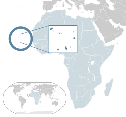
Cape Verde () or Cabo Verde (, ; Portuguese: [ˈkabu ˈveɾdɨ]), officially the Republic of Cabo Verde, is an archipelago and island country in the central Atlantic Ocean, consisting of ten volcanic islands with a combined land area of about 4,033 square kilometres (1,557 sq mi).[10] These islands lie between 600 and 850 kilometres (320 and 460 nautical miles) west of Cap-Vert, the westernmost point of continental Africa. The Cape Verde islands form part of the Macaronesia ecoregion, along with the Azores, the Canary Islands, Madeira, and the Savage Isles.
The Cape Verde archipelago was uninhabited until the 15th century, when Portuguese explorers discovered and colonized the islands, thus establishing the first European settlement in the tropics. Because the Cape Verde islands were located in a convenient location to play a role in the Atlantic slave trade, Cape Verde became economically prosperous during the 16th and 17th centuries, attracting merchants, privateers, and pirates. It declined economically in the 19th century after the suppression of the Atlantic slave trade, and many of its inhabitants emigrated during that period. However, Cape Verde gradually recovered economically by becoming an important commercial center and useful stopover point along major shipping routes. In 1951, Cape Verde was incorporated as an overseas department of Portugal, but its inhabitants continued to campaign for independence, which they achieved in 1975.
Since the early 1990s, Cape Verde has been a stable representative democracy and has remained one of the most developed and democratic countries in Africa. Lacking natural resources, its developing economy is mostly service-oriented, with a growing focus on tourism and foreign investment. Its population of around 483,628 (as of the 2021 Census) is mostly of mixed African and European heritage, and predominantly Roman Catholic, reflecting the legacy of Portuguese rule. A sizeable Cape Verdean diaspora community exists across the world, especially in the United States and Portugal, considerably outnumbering the inhabitants on the islands. Cape Verde is a member state of the African Union.
Cape Verde’s official language is Portuguese.[11] It is the language of instruction and government. It is also used in newspapers, television, and radio. The recognized national language is Cape Verdean Creole, which is spoken by the vast majority of the population.
Etymology[edit]
The country is named after the Cap-Vert peninsula, on the Senegalese coast.[12] The name Cap-Vert, in turn, comes from the Portuguese language Cabo Verde (‘green cape’), the name that Portuguese explorers gave the cape in 1444, a few years before they came across the islands.
On 24 October 2013, the country’s delegation to the United Nations informed it that other countries should no longer use Cape Verde or any other translations of Cabo Verde as part of its official name: all countries should use Republic of Cabo Verde as the country’s official name.[10][13] Speakers of English have used the name Cape Verde for the archipelago and, since independence in 1975, for the country. In 2013, the Cape Verdean government determined that it would thenceforth use the Portuguese name Cabo Verde for official purposes, including at the United Nations, even when speaking or writing in English.
History[edit]
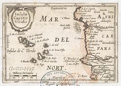
Insulae Capitis Viridis (1598), showing Cape Verde
The archipelago of modern-day Cape Verde was formed approximately 40–50 million years ago during the Eocene era.
Before the arrival of Europeans, the Cape Verde Islands were uninhabited.[14][15][16] They were discovered by Genoese and Portuguese navigators around 1456. According to Portuguese official records,[17] the first discoveries were made by Genoa-born António de Noli, who was afterwards appointed governor of Cape Verde by the Portuguese king Afonso V. Other navigators mentioned as contributing to discoveries on the Cape Verde archipelago are Diogo Dias, Diogo Afonso, Venetian Alvise Cadamosto, and Diogo Gomes (who had accompanied António de Noli on his voyage of discovery, and who claimed to have been the first to land on the Cape Verdean island of Santiago, and the first to name that island).
In 1462, Portuguese settlers arrived at Santiago and founded a settlement they called Ribeira Grande. Today it is called Cidade Velha («Old City»), to distinguish it from a town of the same name on a different Cape Verdean island (Ribeira Grande on the island of Santo Antão). The original Ribeira Grande was the first permanent European settlement in the tropics.[18]

In the 16th century, the archipelago prospered from the Atlantic slave trade.[18] Pirates occasionally attacked the Portuguese settlements. Francis Drake, an English privateer, twice sacked the (then) capital Ribeira Grande in 1585 when it was a part of the Iberian Union.[18] After a French attack in 1712, the town declined in importance relative to nearby Praia, which became the capital in 1770.[18]
The decline in the slave trade in the 19th century resulted in an economic crisis. Cape Verde’s early prosperity slowly vanished. However, the islands’ position astride mid-Atlantic shipping lanes made Cape Verde an ideal location for re-supplying ships. Because of its excellent harbour, the city of Mindelo, located on the island of São Vicente, became an important commercial centre during the 19th century.[18] Diplomat Edmund Roberts visited Cape Verde in 1832.[19] Cape Verde was the first stop of Charles Darwin’s voyage with HMS Beagle in 1832.[20]
Grain ship Garthpool, wrecked at Boavista, Cape Verde, in 1928
With few natural resources and inadequate sustainable investment from the Portuguese, the citizens grew increasingly discontented with the colonial masters, who refused to provide the local authorities with more autonomy. In 1951, Portugal changed Cape Verde’s status from a colony to an overseas province in an attempt to blunt growing nationalism.[18]
In 1956, Amílcar Cabral and a group of fellow Cape Verdeans and Guineans organized (in Portuguese Guinea) the clandestine African Party for the Independence of Guinea and Cape Verde (PAIGC).[18] It demanded improvement in economic, social and political conditions in Cape Verde and Portuguese Guinea and formed the basis of the two nations’ independence movement. Moving its headquarters to Conakry, Guinea in 1960, the PAIGC began an armed rebellion against Portugal in 1961. Acts of sabotage eventually grew into a war in Portuguese Guinea that pitted 10,000 Soviet Bloc-supported PAIGC soldiers against 35,000 Portuguese and African troops.[18]
By 1972, the PAIGC controlled much of Portuguese Guinea despite the presence of the Portuguese troops, but the organization did not attempt to disrupt Portuguese control in Cape Verde. Portuguese Guinea declared independence in 1973 and was granted de jure independence in 1974. A budding independence movement – originally led by Amílcar Cabral, assassinated in 1973 – passed on to his half-brother Luís Cabral and culminated in independence for the archipelago in 1975.
Independence (1975)[edit]

Following the April 1974 revolution in Portugal, the PAIGC became an active political movement in Cape Verde. In December 1974, the PAIGC and Portugal signed an agreement providing for a transitional government composed of Portuguese and Cape Verdeans. On 30 June 1975, Cape Verdeans elected a National Assembly which received the instruments of independence from Portugal on 5 July 1975.[18] In the late 1970s and 1980s, most African countries prohibited South African Airways from overflights but Cape Verde allowed them and became a centre of activity for the airline’s flights to Europe and the United States.
Immediately following the November 1980 coup in Guinea-Bissau, relations between Cape Verde and Guinea-Bissau became strained. Cape Verde abandoned its hope for unity with Guinea-Bissau and formed the African Party for the Independence of Cape Verde (PAICV). Problems have since been resolved and relations between the countries are good. The PAICV and its predecessor established a one-party system and ruled Cape Verde from independence until 1990.[18]
Responding to growing pressure for pluralistic democracy, the PAICV called an emergency congress in February 1990 to discuss proposed constitutional changes to end one-party rule. Opposition groups came together to form the Movement for Democracy (MpD) in Praia in April 1990. Together, they campaigned for the right to contest the presidential election scheduled for December 1990.
The one-party state was abolished on 28 September 1990, and the first multi-party elections were held in January 1991. The MpD won a majority of the seats in the National Assembly, and MpD presidential candidate António Mascarenhas Monteiro defeated the PAICV’s candidate with 73.5% of the votes. Legislative elections in December 1995 increased the MpD majority in the National Assembly. The party won 50 of the National Assembly’s 72 seats.
A February 1996 presidential election returned President Monteiro to office. Legislative elections in January 2001 returned power to the PAICV, with the PAICV holding 40 of the National Assembly seats, MpD 30, and Party for Democratic Convergence (PCD) and Labour and Solidarity Party (PTS) 1 each. In February 2001, the PAICV-supported presidential candidate Pedro Pires defeated former MpD leader Carlos Veiga by only 13 votes.[18]
President Pedro Pires was narrowly re-elected in 2006 elections.[21]
President Jorge Carlos Fonseca led the country since 2011 Cape Verde presidential election and he was re-elected in the 2016 election. He was supported by the Movement for Democracy Party.[22] MpD also won in the 2016 parliamentary elections, taking back parliamentary majority after 15 year-rule of African Party for the Independence of Cape Verde (PAICV).[23] In April 2021, the ruling center-right Movement for Democracy (MpD) of Prime Minister Ulisses Correia e Silva won the parliamentary election.[24]
In October 2021, opposition candidate and former prime minister, Jose Maria Neves of PAICV, won Cape Verde’s presidential election.[25] On 9 November 2021, Jose Maria Neves was sworn in as the new President of Cape Verde.[26]
Government and politics[edit]


Palácio da Justiça – Palace of Justice, in Praia
Cape Verde is a stable semi-presidential representative democratic republic.[4][27] It is among the most democratic nations in Africa, ranking 26th in the world, according to the 2018 Democracy Index.[28] The constitution – adopted in 1980 and revised in 1992, 1995 and 1999 – defines the basic principles of its government. The president is the head of state and is elected by popular vote for a five-year term.[18]
The prime minister is the head of government and proposes other ministers and secretaries of state. The prime minister is nominated by the National Assembly and appointed by the president.[citation needed] Members of the National Assembly are elected by popular vote for five-year terms. In 2016, three parties held seats in the National Assembly – MpD (36), PAICV (25), and the Cape Verdean Independent Democratic Union (UCID) (3).[29]
The two main political parties are PAICV and MpD.[29]
Movement for Democracy (MpD) ousted the ruling African Party for the Independence of Cape Verde (PAICV) for the first time in 15 years in the 2016 parliamentary election, at which time its leader, Ulisses Correia e Silva, became prime minister. Jorge Carlos Almeida Fonseca was elected president in August 2011 and re-elected in October 2016. He is also supported by the MpD.[30]
In November 2021, Cape Verde opened its first embassy in Nigeria. [31]
International recognition[edit]
Cape Verde is often praised as an example among African nations for its stability and developmental growth despite its lack of natural resources. In 2013 then United States President Barack Obama said Cape Verde is «a real success story».[32] Among other achievements, it has been recognized with the following assessments:
| Index | Score | PALOP rank | CPLP rank | African rank | World rank | Year |
|---|---|---|---|---|---|---|
| Human Development Index | 0.654 | 1 (top 17%) | 3 (top 38%) | 10 (top 19%)[A] | 125 (top 62%) | 2017[33] |
| Ibrahim Index of African Governance | 71.1 | 1 (top 17%) | — | 3 (top 6%) | — | 2018[34] |
| Freedom of the Press | 27 (Free) | 1 (top 17%) | 2 (top 25%) | 1 (top 2%) | 48 (top 24%) | 2014 |
| Freedom in the World | 1/1[B] | 1 (top 17%) | 1 (top 13%)[C] | 1 (top 2%)[D] | 1 (top 1%)[E] | 2016 |
| Press Freedom Index | 18.02 | 1 (top 17%) | 2 (top 25%) | 3 (top 6%) | 27 (top 14%) | 2017 |
| Democracy Index | 7.88 (Flawed democracy) | 1 (top 17%) | 1 (top 13%) | 2 (top 4%) | 26 (top 13%) | 2018 |
| Corruption Perceptions Index | 59 | 1 (top 17%) | 2 (top 25%) | 2 (top 4%) | 38 (top 19%) | 2016 |
| Index of Economic Freedom[35] | 66.5 | 1 (top 17%) | 1 (top 13%) | 3 (top 6%) | 57 (top 28%) | 2016 |
| e-Government Readiness Index | 0.3551 | 1 (top 17%) | 3 (top 38%) | 14 (top 26%) | 127 (top 63%) | 2014 |
| Failed States Index | 74.1 | 1 (top 17%) | 3 (top 38%) | 8 (top 15%) | 93 (top 46%)[F] | 2014 |
| Networked Readiness Index | 3.8 | 1 (top 17%) | 3 (top 38%) | 7 (top 13%) | 87 (top 43%) | 2015[36] |
- A See List of countries by Human Development Index § Africa
- B 1/1 is the highest possible rating.
- C With the maximum score, Cape Verde shares first place with Portugal.
- D Cape Verde was the only African country to reach the maximum rating.
- E With the maximum score, Cape Verde shares first place with 48 other countries.
- F The rank on this list is expressed in reverse order. To be comparable with the other rankings on this table, the actual rank of 88 was inverted, by subtracting it from the number of countries on the list, currently 177.
Foreign relations[edit]

Map of countries with Cape Verdean embassies
Cape Verde follows a policy of nonalignment and seeks cooperative relations with all friendly states.[18] Angola, Brazil, China, Libya, Cuba, France, Germany, Portugal, Spain, Senegal, Russia, Luxembourg, and the United States maintain embassies in Praia.[18] Cape Verde maintains a vigorously active foreign policy, especially in Africa.[18]
Cape Verde is a founding member state of the Community of Portuguese Language Countries (CPLP), also known as the Lusophone Commonwealth, an international organization and political association of Lusophone nations across four continents, where Portuguese is an official language.
Cape Verde has bilateral relations with some Lusophone nations and holds membership in a number of international organizations.[18] It also participates in most international conferences on economic and political issues.[18] Since 2007, Cape Verde has a special partnership status[37] with the EU, under the Cotonou Agreement, and might apply for special membership, in particular because the Cape Verdean escudo, the country’s currency, is indexed to the euro.[38] In 2011 Cape Verde ratified the Rome Statute of the International Criminal Court.[39] In 2017 Cape Verde signed the UN treaty on the Prohibition of Nuclear Weapons.[40]
Judiciary[edit]
The judicial system consists of a Supreme Court of Justice – whose members are appointed by the president, the National Assembly, and the Board of the Judiciary – and regional courts. Separate courts hear civil, constitutional, and criminal cases. Appeals are to the Supreme Court.[18]
Military[edit]

Marines of the Cape Verdean Coast Guard
The military of Cape Verde consists of the National Guard and the Coast Guard; 0.7% of the country’s GDP was spent on the military in 2005.
Having fought their only battles in the war for independence against Portugal between 1974 and 1975, the efforts of the Cape Verdean armed forces have turned to combating international drug trafficking. In 2007, together with the Cape Verdean Police, they carried out Operation Flying Launch (Operacão Lancha Voadora), a successful operation to put an end to a drug trafficking group which smuggled cocaine from Colombia to the Netherlands and Germany using the country as a reorder point. The operation took more than three years, being a secret operation during the first two years, and ended in 2010. In 2016, Cape Verdean Armed Forces were involved in the Monte Tchota massacre, a green-on-green incident that resulted in 11 deaths.[41]
Although located in Africa, Cape Verde has always had close relations with Europe. Because of this, some scholars argue that Cape Verde may be eligible to join the Organization for Security and Co-operation in Europe (OSCE) and NATO.[42]
Geography[edit]


A satellite photo of the Cape Verde islands, 2010
The Cape Verde archipelago is in the Atlantic Ocean, approximately 570 kilometres (350 mi) off the western coast of the African continent, near Senegal, Gambia, and Mauritania as well as part of the Macaronesia ecoregion. It lies between latitudes 14° and 18°N, and longitudes 22° and 26°W.
The country is a horseshoe-shaped cluster of ten islands (nine inhabited) and eight islets,[43] that constitute an area of 4033 km2 (1557 sq. mi.).[43]
The islands are spatially divided into two groups:
- The Barlavento Islands (windward islands): Santo Antão, São Vicente, Santa Luzia, São Nicolau, Sal, Boa Vista;[43] and
- The Sotavento Islands (leeward): Maio, Santiago, Fogo, Brava.[43]
The largest island, both in size and population, is Santiago, which hosts the nation’s capital, Praia, the principal urban agglomeration in the archipelago.[43]
Three of the Cape Verde islands, Sal, Boa Vista, and Maio, are fairly flat, sandy, and dry; the others are generally rockier with more vegetation.
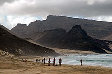
The beach of Calhau, with Monte Verde in the background, on the island of São Vicente
Physical geography and geology[edit]

The countryside in Estrada Baía das Gatas

Geologically, the islands, covering a combined area of slightly over 4,033 square kilometres (1,557 square miles), are principally composed of igneous rocks, with volcanic structures and pyroclastic debris comprising the majority of the archipelago’s total volume. The volcanic and plutonic rocks are distinctly basic; the archipelago is a soda-alkaline petrographic province, with a petrologic succession similar to that found in other Macaronesian islands.
Magnetic anomalies identified in the vicinity of the archipelago indicate that the structures forming the islands date back 125–150 million years: the islands themselves date from 8 million (in the west) to 20 million years (in the east).[44] The oldest exposed rocks occurred on Maio and the northern peninsula of Santiago and are 128–131 million-year-old pillow lavas. The first stage of volcanism in the islands began in the early Miocene, and reached its peak at the end of this period when the islands reached their maximum sizes. Historical volcanism (within human settlement) has been restricted to the island of Fogo.[45]
The islands lie on a bathymetric swell known as the Cape Verde Rise.[46] The Rise is one of the largest protuberances in the world’s oceans, rising 2.2 kilometres (1.4 miles) in a semi-circular region of 1200 km2 (460 sq. mi.), associated with a rise of the geoid.[44]
Pico do Fogo, the largest active volcano in the region, erupted in 2014. It has an eight-kilometre-diameter (five-mile) caldera, the rim of which is at an elevation of 1,600 metres (5,249 feet) and an interior cone that rises to 2,829 metres (9,281 feet) above sea level. The caldera resulted from subsidence, following the partial evacuation (eruption) of the magma chamber, along a cylindrical column from within the magma chamber (at a depth of 8 kilometres (5 miles)).
Extensive salt flats are found on Sal and Maio.[43] On Santiago, Santo Antão, and São Nicolau, arid slopes give way in places to sugarcane fields or banana plantations spread along the base of towering mountains.[43] Ocean cliffs have been formed by catastrophic debris landslides.[47]
According to the president of Nauru, in 2011 Cape Verde was ranked the eighth most endangered nation due to flooding from climate change.[48]
Climate[edit]
Cape Verde’s climate is milder than that of the African mainland because the surrounding sea moderates temperatures on the islands and cold Atlantic currents produce an arid atmosphere around the archipelago. Conversely, the islands do not receive the upwelling (cold streams) that affect the West African coast, so the air temperature is cooler than in Senegal, but the sea is warmer. Due to the relief of some islands, such as Santiago with its steep mountains, the islands can have orographically induced precipitation, allowing rich woods and luxuriant vegetation to grow where the humid air condenses soaking the plants, rocks, soil, logs, moss, etc. On the higher islands and somewhat wetter islands, exclusively in mountainous areas, like Santo Antão island, the climate is suitable for the development of dry monsoon forests, and laurel forests.[43] Average temperatures range from 22 °C (72 °F) in February to 27 °C (80.6 °F) in September.[49] Cape Verde is part of the Sahelian arid belt, with nothing like the rainfall levels of nearby West Africa.[43] It rains irregularly between August and October, with frequent brief heavy downpours.[43] A desert is usually defined as terrain that receives less than 250 mm (9.8 in) of annual rainfall. Sal’s total of 145 mm (5.7 in) confirms this classification. Most of the year’s rain falls in September.[49]
Sal, Boa Vista, and Maio have a flat landscape and arid climate, whilst the other islands are generally rockier and have more vegetation. Because of the infrequent occurrence of rainfall, where not mountainous, the landscape is so arid that less than two percent of it is arable.[50] The archipelago can be divided into four broad ecological zones — arid, semiarid, subhumid and humid, according to altitude and average annual rainfall ranging from less than 100 millimetres (3.9 inches) in the arid areas of the coast as in the Deserto de Viana (67 millimetres (2.6 inches) in Sal Rei) to more than 1,000 millimetres (39 inches) in the humid mountain. Most rainfall precipitation is due to condensation of the ocean mist.
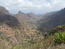
In some islands, like Santiago, the wetter climate of the interior and the eastern coast contrasts with the drier one on the south/southwest coast. Praia, on the southeast coast, is the largest city on the island and the largest city and capital of the country.
While most of Cape Verde receives little precipitation throughout the year, the northeastern slopes of high mountains see significant rainfall due to orographic lift, especially in areas far from the sea. In some such areas this precipitation is sufficient to support a rainforest habitat, albeit one significantly affected by the islands’ human presence. These umbria areas are identified as cool and moist. Cape Verde lies in the Cape Verde Islands dry forests ecoregion.[51]
Western Hemisphere-bound hurricanes often have their early beginnings near the Cape Verde Islands. These are referred to as Cape Verde-type hurricanes. These hurricanes can become very intense as they cross warm Atlantic waters away from Cape Verde. The average hurricane season has about two Cape Verde-type hurricanes, which are usually the largest and most intense storms of the season because they often have plenty of warm open ocean over which to develop before encountering land. The five largest Atlantic tropical cyclones on record have been Cape Verde-type hurricanes. Most of the longest-lived tropical cyclones in the Atlantic basin are Cape Verde hurricanes.[citation needed]
As of 2015, the islands themselves have only been struck by hurricanes twice in recorded history (since 1851): once in 1892, and again in 2015 by Hurricane Fred, the easternmost hurricane ever to form in the Atlantic.[citation needed]
| Climate data for Cape Verde: São Vicente, Sal and Santiago, 1981–2010 normals, 1931–1960 extremes | |||||||||||||
|---|---|---|---|---|---|---|---|---|---|---|---|---|---|
| Month | Jan | Feb | Mar | Apr | May | Jun | Jul | Aug | Sep | Oct | Nov | Dec | Year |
| Record high °C (°F) | 32.0 (89.6) |
33.1 (91.6) |
34.2 (93.6) |
33.4 (92.1) |
33.3 (91.9) |
34.1 (93.4) |
33.6 (92.5) |
38.0 (100.4) |
34.8 (94.6) |
33.0 (91.4) |
33.0 (91.4) |
31.0 (87.8) |
38.0 (100.4) |
| Average high °C (°F) | 24.9 (76.8) |
25.1 (77.2) |
25.8 (78.4) |
25.9 (78.6) |
26.6 (79.9) |
27.3 (81.1) |
28.2 (82.8) |
29.4 (84.9) |
29.9 (85.8) |
29.5 (85.1) |
28.2 (82.8) |
26.3 (79.3) |
27.3 (81.1) |
| Daily mean °C (°F) | 22.1 (71.8) |
21.9 (71.4) |
22.4 (72.3) |
22.7 (72.9) |
23.4 (74.1) |
24.3 (75.7) |
25.3 (77.5) |
26.5 (79.7) |
26.9 (80.4) |
26.4 (79.5) |
25.2 (77.4) |
23.4 (74.1) |
24.2 (75.6) |
| Average low °C (°F) | 19.4 (66.9) |
19.1 (66.4) |
19.3 (66.7) |
19.8 (67.6) |
20.6 (69.1) |
21.6 (70.9) |
22.7 (72.9) |
23.9 (75.0) |
24.5 (76.1) |
23.8 (74.8) |
22.6 (72.7) |
20.9 (69.6) |
21.5 (70.7) |
| Record low °C (°F) | 12.0 (53.6) |
10.0 (50.0) |
12.0 (53.6) |
15.0 (59.0) |
15.0 (59.0) |
15.0 (59.0) |
17.0 (62.6) |
14.5 (58.1) |
19.0 (66.2) |
18.5 (65.3) |
17.0 (62.6) |
16.0 (60.8) |
10.0 (50.0) |
| Average precipitation mm (inches) | 4.9 (0.19) |
1.5 (0.06) |
0.7 (0.03) |
0.4 (0.02) |
0.3 (0.01) |
0.0 (0.0) |
3.9 (0.15) |
30.2 (1.19) |
41.7 (1.64) |
18.8 (0.74) |
3.7 (0.15) |
3.1 (0.12) |
109.2 (4.3) |
| Average relative humidity (%) | 66.9 | 67.3 | 66.9 | 67.8 | 69.5 | 72.3 | 73.8 | 75.3 | 76.0 | 73.5 | 70.7 | 69.5 | 70.8 |
| Mean monthly sunshine hours | 213.4 | 184.9 | 197.1 | 199.0 | 195.4 | 175.1 | 165.4 | 160.7 | 165.1 | 185.3 | 186.2 | 202.9 | 2,230.5 |
| Source 1: Instituto Nacional de Meteorologia e Geofísica[49] | |||||||||||||
| Source 2: Deutscher Wetterdienst (extremes)[52][53][54] |
Biodiversity[edit]
Cape Verde’s isolation has resulted in the islands having several endemic species, particularly birds and reptiles, many of which are endangered by human development. Endemic birds include Alexander’s swift (Apus alexandri), Bourne’s heron (Ardea purpurea bournei), the Raso lark (Alauda razae), the Cape Verde warbler (Acrocephalus brevipennis), and the Iago sparrow (Passer iagoensis).[55] The islands are also an important breeding area for seabirds including the Cape Verde shearwater. Reptiles include the Cape Verde giant gecko (Tarentola gigas).
Administrative divisions[edit]
Cape Verde is divided into 22 municipalities (concelhos) and subdivided into 32 parishes (freguesias), based on the religious parishes that existed during the colonial period:
| Island | Municipality | Census 2010[56] | Census 2021[57] | Parish |
| Santo Antão | Ribeira Grande | 18,890 | 15,022 | Nossa Senhora do Rosário |
| Nossa Senhora do Livramento | ||||
| Santo Crucifixo | ||||
| São Pedro Apóstolo | ||||
| Paúl | 6,997 | 5,696 | Santo António das Pombas | |
| Porto Novo | 18,028 | 15,014 | São João Baptista | |
| Santo André | ||||
| São Vicente | São Vicente | 76,107 | 74,016 | Nossa Senhora da Luz |
| Santa Luzia | ||||
| São Nicolau | Ribeira Brava | 7,580 | 6,978 | Nossa Senhora da Lapa |
| Nossa Senhora do Rosário | ||||
| Tarrafal de São Nicolau | 5,237 | 5,261 | São Francisco | |
| Sal | Sal | 25,765 | 33,347 | Nossa Senhora das Dores |
| Boa Vista | Boa Vista | 9,162 | 12,613 | Santa Isabel |
| São João Baptista |
| Island | Municipality | Census 2010[56] | Census 2021[57] | Parish |
| Maio | Maio | 6,952 | 6,298 | Nossa Senhora da Luz |
| Santiago | Praia | 131,602 | 142,009 | Nossa Senhora da Graça |
| São Domingos | 13,808 | 13,958 | Nossa Senhora da Luz | |
| São Nicolau Tolentino | ||||
| Santa Catarina | 43,297 | 37,472 | Santa Catarina | |
| São Salvador do Mundo | 8,677 | 7,452 | São Salvador do Mundo | |
| Santa Cruz | 26,609 | 25,004 | Santiago Maior | |
| São Lourenço dos Órgãos | 7,388 | 6,317 | São Lourenço dos Órgãos | |
| Ribeira Grande de Santiago | 8,325 | 7,632 | Santíssimo Nome de Jesus | |
| São João Baptista | ||||
| São Miguel | 15,648 | 12,906 | São Miguel Arcanjo | |
| Tarrafal | 18,565 | 16,620 | Santo Amaro Abade | |
| Fogo | São Filipe | 22,228 | 20,732 | São Lourenço |
| Nossa Senhora da Conceição | ||||
| Santa Catarina do Fogo | 5,299 | 4,725 | Santa Catarina do Fogo | |
| Mosteiros | 9,524 | 8,062 | Nossa Senhora da Ajuda | |
| Brava | Brava | 5,995 | 5,594 | São João Baptista |
| Nossa Senhora do Monte |
Economy[edit]
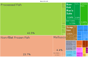
A proportional representation of Cape Verde exports, 2019
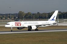
Cape Verde’s notable economic growth and improvement in living conditions despite a lack of natural resources have garnered international recognition, with other countries and international organizations often providing development aid. Since 2007, the UN has classified it as a developing nation rather than a least developed country.
Cape Verde has few natural resources. Only five of the ten main islands (Santiago, Santo Antão, São Nicolau, Fogo, and Brava) normally support significant agricultural production,[58] and over 90% of all food consumed in Cape Verde is imported. Mineral resources include salt, pozzolana (a volcanic rock used in cement production), and limestone.[18] Its small number of wineries making Portuguese-style wines have traditionally focused on the domestic market, but have recently met with some international acclaim. Several wine tours of Cape Verde’s various microclimates began to be offered in spring 2010.
The economy of Cape Verde is service-oriented, with commerce, transport, and public services accounting for more than 70% of GDP.[59] Although nearly 35% of the population lives in rural areas, agriculture and fishing contribute only about 9% of GDP. Light manufacturing accounts for most of the remainder. Fish and shellfish are plentiful, and small quantities are exported. Cape Verde has cold storage and freezing facilities and fish processing plants in Mindelo, Praia, and on Sal. Expatriate Cape Verdeans contribute an amount estimated at 20% of GDP to the domestic economy through remittances.[18]
Despite having few natural resources and being semi-desert, the country boasts the highest living standards in the region and has attracted thousands of immigrants of different nationalities.
Since 1991, the government has pursued market-oriented economic policies, including an open welcome to foreign investors and a far-reaching privatization programme. It established as top development priorities the promotion of a market economy and the private sector; the development of tourism, light manufacturing industries, and fisheries; and the development of transport, communications, and energy facilities. From 1994 to 2000 about $407 million in foreign investments were made or planned, of which 58% were in tourism,[60] 17% in industry, 4% in infrastructure, and 21% in fisheries and services.[18]
In 2011, on four islands a wind farm was built that supplies about 30% of the electricity of the country.[61]
As host to the ECOWAS Regional Centre for Renewable Energy and Energy Efficiency, inaugurated in 2010, Cape Verde plans to lead by example by becoming entirely reliant on renewable energy sources by 2025.[62] This policy is consistent with the plethora of documents adopted in 2015 paving the way to more sustainable development, including Cape Verde’s Transformational Agenda to 2030, its National Renewable Energy Plan and its Low Carbon and Climate-resilient Development Strategy. Two years later, these were followed by a Strategic Plan for Sustainable Development, 2017–2021.[62]
Between 2000 and 2009, real GDP increased on average by over seven percent a year, well above the average for Sub-Saharan countries and faster than most small island economies in the region. Strong economic performance was bolstered by one of the fastest growing tourism industries in the world, as well as by substantial capital inflows that allowed Cape Verde to build up national currency reserves to the current 3.5 months of imports. Unemployment has been falling rapidly, and the country is on track to achieve most of the UN Millennium Development Goals – including halving its 1990 poverty level.
In 2007, Cape Verde joined the World Trade Organization (WTO) and in 2008 the country graduated from Least Developed Country (LDC) to Middle Income Country (MIC) status.[63][64]

Cabral Avenue, one of the main symbols of Cape Verde’s development
Cape Verde has significant cooperation with Portugal at every level of the economy, which has led it to link its currency first to the Portuguese escudo and, in 1999, to the euro. On 23 June 2008 Cape Verde became the 153rd member of the WTO.[65]
In early January 2018, the government announced that the minimum wage would be raised to 13,000 CVE (US$140 or EUR 130) per month, from 11,000 CVE, which was effective in mid-January 2018.[66][67]
Development[edit]
The European Commission’s total allocation for the period of 2008–2013 foreseen for Cape Verde to address «poverty reduction, in particular in rural and peri-urban areas where women are heading the households, as well as good governance» amounts to €54.1 million.[68]
Tourism[edit]
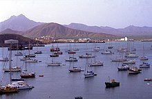
Yachts in Porto Grande, Mindelo, on the island of São Vicente. Tourism is a growing source of income on the islands.
Cape Verde’s strategic location at the crossroads of mid-Atlantic air and sea lanes has been enhanced by significant improvements at Mindelo’s harbour (Porto Grande) and at Sal’s and Praia’s international airports. A new international airport was opened in Boa Vista in December 2007 and on the island of São Vicente, the newest international airport (Cesária Évora Airport) in Cape Verde was opened in late 2009. Ship repair facilities at Mindelo were opened in 1983.[18]
The major ports are Mindelo and Praia, but all other islands have smaller port facilities. In addition to the international airport on Sal, airports have been built on all of the inhabited islands. All but the airports on Brava and Santo Antão enjoy scheduled air service. The archipelago has 3,050 km (1,895 mi) of roads, of which 1,010 km (628 mi) are paved, most using cobblestone.[18]
The country’s future economic prospects depend heavily on the maintenance of aid flows, the encouragement of tourism, remittances, outsourcing labour to neighbouring African countries, and the momentum of the government’s development programme.[18]
Demographics[edit]

Cape Verde’s population, 1961–2003

The official Census recorded that Cape Verde had a population of 512,096 in 2013.[69] A large proportion (236,000) of Cape Verdeans live on the main island, Santiago.[70]
Cape Verdeans are descendants of Africans (free or slaves) and Europeans of various origins. There are also Cape Verdeans who have Jewish ancestors from North Africa, mainly on the islands of Boa Vista, Santiago and Santo Antão. A large part of Cape Verdeans emigrated abroad, mainly to the United States, Portugal and France, so that there are more Cape Verdeans residing abroad than at home.
Unlike countries on the African continent, there are no tribes in Cape Verde. On the other hand, the country’s historical trajectory included, from the beginning, a process of social class formation. At this moment, the absence of a «bourgeoisie» can be seen, but the existence of several types of «petty bourgeoisie», numerically significant. The majority of the population is, however, made up of the peasantry and some working class.[71]
|
Largest cities or towns in Cape Verde Instituto Nacional de Estatística (Distribuição da população residente — RGPH 2010: População urbana) |
|||||
|---|---|---|---|---|---|
| Rank | Name | Municipality | Pop. | ||
 Praia  Mindelo |
1 | Praia | Praia | 127,832 |  Santa Maria  Assomada |
| 2 | Mindelo | São Vicente | 70,468 | ||
| 3 | Santa Maria | Sal | 23,839 | ||
| 4 | Assomada | Santa Catarina | 12,026 | ||
| 5 | Porto Novo | Porto Novo | 9,430 | ||
| 6 | Pedra Badejo | Santa Cruz | 9,345 | ||
| 7 | São Filipe | São Filipe | 8,125 | ||
| 8 | Tarrafal | Tarrafal | 6,177 | ||
| 9 | Sal Rei | Boa Vista | 5,407 | ||
| 10 | Ribeira Grande | Ribeira Grande | 4,625 |
Languages[edit]
Cape Verde’s official language is Portuguese.[1] It is the language of instruction and government. It is also used in newspapers, television, and radio.
Cape Verdean Creole (Kriolu) is used colloquially throughout Cape Verde and is the mother tongue of virtually all Cape Verdeans. The national constitution calls for measures to give it parity with Portuguese.[1] There is a substantial body of literature in Creole, especially in the Santiago Creole and the São Vicente Creole. Kriolu has been gaining prestige since the nation’s independence from Portugal.
The differences between the forms of the language within the islands have been a major obstacle in the way of standardization of the language. Some people have advocated the development of two standards: a North (Barlavento) standard, centred on the São Vicente Creole, and a South (Sotavento) standard, centred on the Santiago Creole. Manuel Veiga, Ph.D., a linguist and Minister of Culture of Cape Verde, is the premier proponent of Kriolu‘s officialization and standardization.[72]
Religion[edit]
Religion in Cape Verde (2010)[73]
Other Christian (10.4%)
Other or non-religious (10.9%)
The vast majority of Cape Verdeans are Christian; reflecting centuries of Portuguese rule, Roman Catholics make up the single largest religious community, at just under 80 percent, as of 2010 (slightly down from 85 percent of the population in 2007).[74] Most other religious groups are Protestant, with the evangelical Church of the Nazarene forming the second largest community; other sizeable denominations are the Seventh-day Adventist Church, the Assemblies of God, the Universal Church of the Kingdom of God and the Church of Jesus Christ of Latter-day Saints.[74] Islam is the largest minority religion.[74] Judaism had a historical presence during the colonial era.[75] Atheists constitute less than 1 percent of the population.[74] Many Cape Verdeans syncretize Christianity with indigenous African beliefs and customs.[76]
Emigration and immigration[edit]
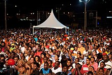
People in Santiago, the largest island in the country
Almost twice as many Cape Verdeans live abroad (nearly one million) than in the country itself.[77] The islands have a long history of emigration and Cape Verdeans are highly dispersed worldwide, from Macau to Haiti and Argentina to Sweden.[78] The diaspora may be much larger than official statistics indicate, as, until independence in 1975, Cape Verdean immigrants had Portuguese passports.
The majority of Cape Verdeans live in the United States and Western Europe, with the former hosting the largest overseas population at 500,000. Most Cape Verdeans in the U.S. are concentrated in New England, particularly the cities of Providence, New Bedford, and Boston; Brockton, Massachusetts, has the largest community of any American city (18,832).[79] Cape Verdean immigrants have a long history of enlistment in the U.S. military, with a presence in every major conflict from the Revolutionary War to the Vietnam War.[80]
Due to centuries of colonial ties, the second largest number of Cape Verdeans live in Portugal (150,000), with sizeable communities in the former Portuguese colonies of Angola (45,000) and São Tomé and Príncipe (25,000). Major populations exist in countries with cultural and linguistic similarities, such as Spain (65,500), France (25,000), Senegal (25,000), and Italy (20,000). Other large communities live in the United Kingdom (35,500), the Netherlands (20,000, of which 15,000 are concentrated in Rotterdam), and Luxembourg and Scandinavia (7,000). Outside the U.S. and Europe, the biggest Cape Verdean populations are in Mexico (5,000) and Argentina (8,000).
Over the years, Cape Verde has increasingly become a net recipient of migrants, due to its relatively high per capita income, political and social stability, and civil freedom.[citation needed] Chinese make up a sizeable and important segment of the foreign population, while nearby West African countries account for most immigration. In the 21st century, a few thousand Europeans and Latin Americans have settled in the country, mostly professionals, entrepreneurs, and retirees. Over 22,000 foreign-born residents are naturalized, hailing from over 90 countries.
The Cape Verdean diaspora experience is reflected in many artistic and cultural expressions, most famously the song Sodade by Cesária Évora.[81]
Health[edit]

A health clinic in a residential area of Praia
The infant mortality rate among Cape Verdean children between 0 and 5 years old is 15 per 1,000 live births according to the latest (2017) data from the National Statistics Bureau,[82] while the maternal mortality rate is 42 deaths per 100,000 live births. The HIV-AIDS prevalence rate among Cape Verdeans between 15 and 49 years old is 0.8%.[83]
According to the latest data (2017) from the National Statistics Bureau,[82] life expectancy at birth in Cape Verde is 76.2 years; that is, 72.2 years for males and 80.2 years for females. There are six hospitals in the Cape Verde archipelago: two central hospitals (one in the capital city of Praia and one in Mindelo, São Vicente) and four regional hospitals (one in Santa Catarina (northern Santiago region), one on São Antão, one on Fogo, and one on Sal). In addition, there are 28 health centers, 35 sanitation centers, and a variety of private clinics located throughout the archipelago.
Cape Verde’s population is among the healthiest in Africa. Since its independence, it has greatly improved its health indicators. Besides having been promoted to the group of «medium development» countries in 2007, leaving the least developed countries category (becoming the second country to do so[84]), as of 2020 it was the 11th best ranked country in Africa in its Human Development Index.
The total expenditure on health was 7.1% of GDP (2015).
Education[edit]

A kindergarten graduation on Santiago Island
Although the Cape Verdean educational system is similar to the Portuguese system, over the years the local universities have been increasingly adopting the American educational system; for instance, all ten existing universities in the country offer four-year bachelor’s degree programs as opposed to five-year bachelor’s degree programs that existed before 2010. Cape Verde has the second best educational system in Africa, after South Africa.[citation needed]
Primary school education in Cape Verde is mandatory and free for children between the ages of six and fourteen years.[85]
In 2011, the net enrolment ratio for primary school was 85%.[85][86] Approximately 90% of the total population over 15 years of age is literate, and roughly 25% of the population holds a college degree; a significant number of these college graduates hold doctorate degrees in different academic fields. Textbooks have been made available to 90 percent of school children, and 98 percent of the teachers have attended in-service teacher training.[85] Although most children have access to education, some problems remain.[85] For example, there is insufficient spending on school materials, lunches, and books.[85]
As of October 2016, there were 69 secondary schools throughout the archipelago (including 19 private secondary schools) and at least 10 universities in the country which are based on the two islands of Santiago and São Vicente.

In 2015, 23% of the Cape Verdean population had either attended or graduated from secondary schools.
When it came to higher education, 9% of Cape Verdean men and 8% of Cape Verdean women held a bachelor’s degree or had attended universities. The overall college education rate (i.e., college graduates and undergraduate students) in Cape Verde is about 24%, of the local college-age population.[87]
The total expenditure on education was 5.6% of GDP (2010).
The mean years of schooling of adults over 25 years is 12.
These trends were held in 2017. Cape Verde stands out in West Africa for the quality and inclusiveness of its higher education system. As of 2017, one in four young people attended university and one-third of students opted for fields of science, technology, engineering, and mathematics.[62] Women made up one-third of students but two-thirds of graduates in 2018.[62]
Science and technology[edit]
In 2011, Cape Verde devoted just 0.07% of its GDP to research and development, among the lowest rates in West Africa. The Ministry of Higher Education, Science and Culture plan to strengthen the research and academic sectors by emphasizing greater mobility, through exchange programmes and international cooperation agreements. As part of this strategy, Cape Verde is participating in the Ibero-American academic mobility programme that expects to mobilize 200,000 academics between 2015 and 2020.[88] Cape Verde was ranked 89th in the Global Innovation Index in 2021.[89]
Cape Verde counted 25 researchers in 2011, a researcher density of 51 per million inhabitants. The world average was 1,083 per million in 2013. All 25 researchers were working in the government sector in 2011 and one in three were women (36%). There was no research being conducted in either medical or agricultural sciences. Of the eight engineers involved in research and development, one was a woman. Three of the five researchers working in natural sciences were women, as were three of the six social scientists and two of the five researchers from the humanities.[88]
In 2015, the government announced a project to build a technology park for business, research, and development. As of late 2020, the project, now named TechPark Cabo Verde, is slated for completion in June 2022. The project is funded by both the African Development Bank and the government of Cape Verde. The goal of the endeavour, according to Cape Verde Minister of Finance Olavo Correia, is «to attract large international companies to set up shop [in order] to help local companies and start-ups become more competitive».[90]
Crime[edit]
Theft and burglary are common in Cape Verde, especially in crowded environments such as marketplaces, festivals, and celebrations.[91] Often the perpetrators of these crimes are gangs of street children.[91] Murders are concentrated in the major population centres of Praia and Mindelo.[91]
Culture[edit]

The culture of Cape Verde is characterized by a mixture of African and European elements. This is not a sum of two cultures living side by side, but a new culture resulting from an exchange that began in the 15th century.
Cape Verdean social and cultural patterns are unique.[43] Football games and church activities are typical sources of social interaction and entertainment.[43] The traditional walk around the praça (town square) to meet friends is practised regularly in Cape Verde towns.[43]
Media[edit]

Newspapers of Cape Verde including Expresso das Ilhas, A Nação and Já
In towns with electricity, television is available on three channels; one state-owned (RTC – TCV) and three foreign-owned: RTI Cabo Verde launched by the Portuguese-based RTI in 2005; Record Cabo Verde, launched by the Brazilian-based Rede Record on 31 March 2007; and as of 2016, TV CPLP.[citation needed] Premium channels available include the Cape Verdean versions of Boom TV and Zap Cabo Verde, two channels owned by Brazil’s Record.[92] Other premium channels are available in Cape Verde, especially satellite network channels which are common in hotels and villas, though availability is otherwise limited. One such channel is RDP África, the African version of the Portuguese radio station RDP.
As of early 2023, about 99% of the Cape Verdean population own an active cellular phone, 70% have access to the Internet, 11% own a landline telephone, and 2% subscribe to local cable TV. In 2003, Cape Verde had 71,700 main line telephones with an additional 53,300 cellular phones in use throughout the country.
In 2004, there were seven radio stations, six independent and one state-owned. The media is operated by the Cape-Verdean News Agency (secondarily as Inforpress). Nationwide radio stations include RCV, RCV+, Radio Kriola, and the religious station Radio Nova. Local radio stations include Rádio Praia, the first radio station in Cape Verde; Praia FM, the first FM station in the nation; Rádio Barlavento, Rádio Clube do Mindelo and Radio Morabeza in Mindelo.[citation needed]
Music[edit]

The Cape Verdean people are known for their musicality, well expressed by popular manifestations such as the Carnival of Mindelo. Cape Verde music incorporates «African, Portuguese and Brazilian influences.»[93] Cape Verde’s quintessential national music is the morna, a melancholy and lyrical song form typically sung in Cape Verdean Creole. The most popular music genre after morna is the coladeira, followed by funaná and batuque music. Cesária Évora was the best-known Cape Verdean singer in the world, known as the «barefoot diva,» because she liked to perform barefooted on stage. She was also referred to as «The Queen of Morna»[94] as opposed to her uncle Bana, who was referred to as «King of Morna». The international success of Cesária Évora has made other Cape Verdean artists, or descendants of Cape Verdeans born in Portugal, gain more space in the music market. Examples of this are singers Sara Tavares, Lura and Mayra Andrade.
Another great exponent of traditional music from Cape Verde was Antonio Vicente Lopes, better known as Travadinha, and Ildo Lobo, who died in 2004. The House of Culture in the center of the city of Praia is called Ildo Lobo House of Culture, in his honour.
There are also well-known artists born to Cape Verdean parents who excelled themselves in the international music scene. Amongst these artists are jazz pianist Horace Silver, Duke Ellington’s saxophonist Paul Gonsalves, Teófilo Chantre, Paul Pena, the Tavares brothers and singer Lura.
Dance[edit]
Dance forms include the soft dance morna, the coladeira, the Cape Verdean version of the zouk from Guadeloupe called Cabo love, the funaná (a sensual African dance), the batuque dance, and the Cabo Zouk.
Literature[edit]
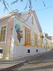
Fundação Amílcar Cabral, in Praia
Cape Verdean literature is one of the richest of Lusophone Africa. Famous poets include Paulino Vieira, Manuel de Novas, Sergio Frusoni, Eugénio Tavares, and B. Léza, and famous authors include Baltasar Lopes da Silva, António Aurélio Gonçalves, Manuel Lopes, Orlanda Amarílis, Henrique Teixeira de Sousa, Arménio Vieira, Kaoberdiano Dambará, Dr. Azágua, and Germano Almeida.[citation needed] The first novel written by a woman from Cabo Verde was A Louca de Serrano by Dina Salústio; its translation, as The Madwoman of Serrano, was the first translation of any Cabo Verdean novel to English.[95][96]
Cinema[edit]
The Carnival and the island of São Vicente are portrayed in the 2015 feature documentary Tchindas, nominated at the 12th Africa Movie Academy Awards.
Cuisine[edit]
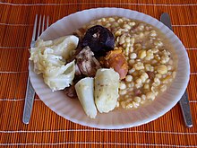
Cachupa, typical Cape Verdean dish
The Cape Verde diet is mostly based on fish and staple foods like corn and rice. Vegetables available during most of the year are potatoes, onions, tomatoes, manioc, cabbage, kale, and dried beans. Fruits such as bananas and papayas are available year-round, while others like mangoes and avocados are seasonal.[43]
A popular dish served in Cape Verde is cachupa, a slow-cooked stew of corn (hominy), beans, and fish or meat. A common appetizer is the pastel, a pastry shell filled with fish or meat which is then fried.[43]
Sports[edit]
![]()
The country’s most successful sports team is the Cape Verde national basketball team, which won the bronze medal at the FIBA Africa Championship 2007, after beating Egypt in its last game. The country’s most well-known player is Walter Tavares, who plays for Real Madrid of Spain.
Cape Verde is famous for wave sailing[citation needed] (a type of windsurfing) and kiteboarding[citation needed]. Josh Angulo, a Hawaiian and 2009 PWA Wave World Champion, has done much to promote the archipelago as a windsurfing destination.[citation needed] Mitu Monteiro, a local kitesurfer, was the 2008 Kite Surfing World Champion in the wave discipline.
The Cape Verde national football team, nicknamed the Tubarões Azuis (Blue Sharks), is the national team of Cape Verde and is controlled by the Cape Verdean Football Federation. The team has played at three Africa Cup of Nations, in 2013, 2015, and 2021.[97]
The country has competed at every Summer Olympics since 1996. In 2016, Gracelino Barbosa became the first Cape Verdean to win a medal at the Paralympic Games.[98]
Transport[edit]
Ports[edit]

Porto Novo harbour in Santo Antão
There are four international ports: Mindelo, Praia, Palmeira and Sal Rei. Mindelo on São Vicente is the main port for cruise ships and the terminus for the ferry service to Santo Antão. Praia on Santiago is the main hub for local ferry services to other islands. Palmeira on Sal supplies fuel for the main airport on the island, Amílcar Cabral International Airport, and is important for the hotel construction taking place on the island. Porto Novo on Santo Antão is the only source for imports and exports of produce from the island as well as passenger traffic since the closure of the airstrip at Ponta do Sol.
There are smaller harbours, essentially single jetties at Tarrafal on São Nicolau, Sal Rei on Boa Vista, Vila do Maio (Porto Inglês) on Maio, São Filipe on Fogo and Furna on Brava. These act as terminals for the inter-island ferry services, which carry both freight and passengers. The pier at Santa Maria on Sal used by both fishing and dive boats has been rehabilitated.
Airports[edit]

There were seven operational airports as of 2014 – four international and three domestic. Two others were non-operational, one on Brava and the other on Santo Antão closed for safety reasons.
Due to its geographical location, Cape Verde is often flown over by transatlantic airliners. It is part of the conventional air traffic route from Europe to South America, which goes from southern Portugal via the Canary Islands and Cape Verde to northern Brazil.
International airports[edit]
- Amílcar Cabral International Airport, Sal Island
- Nelson Mandela International Airport, Santiago Island
- Aristides Pereira International Airport, Boa Vista Island
- Cesária Évora Airport, São Vicente Island
Aerial drones[edit]
Small unmanned flying drones able to carry up to 5kg were being used experimentally for tasks such as delivering medicines between the islands in 2021.[99]
See also[edit]
- Outline of Cape Verde
- Index of Cape Verde–related articles
- Islands of Macaronesia
- Azores
- Madeira
References[edit]
- ^ a b c d «Constituição da República de Cabo Verde» (PDF). ICRC databases on international humanitarian law. Article 9. Archived (PDF) from the original on 12 March 2017. Retrieved 11 March 2017.
- ^ «Cabo Verde – Religion». Encyclopedia Britannica.
- ^ John Kerry (8 July 2014). «On the Occasion of the Republic of Cabo Verde’s National Day». U.S. Department of State. Retrieved 11 July 2014.
On behalf of President Obama and the people of the United States, I send best wishes to Cabo Verdeans as you celebrate 39 years of independence on July 5.
- ^ a b Neto, Octávio Amorim; Lobo, Marina Costa (2010). «Between Constitutional Diffusion and Local Politics: Semi-Presidentialism in Portuguese-Speaking Countries». Social Science Research Network. SSRN 1644026.
- ^ «Population, total — Cabo Verde». World Bank. Retrieved 17 November 2022.
- ^ a b «World Economic Outlook database: April 2022». www.imf.org.
- ^ «GINI index». World Bank. Archived from the original on 20 December 2013. Retrieved 16 June 2021.
- ^ Human Development Report 2020 The Next Frontier: Human Development and the Anthropocene (PDF). United Nations Development Programme. 15 December 2020. pp. 343–346. ISBN 978-92-1-126442-5. Retrieved 16 December 2020.
- ^ «People and Society – Cape Verde». Retrieved 27 August 2017.
- ^ a b Tanya Basu (12 December 2013). «Cape Verde Gets New Name: 5 Things to Know About How Maps Change». National Geographic. Archived from the original on 13 December 2013. Retrieved 12 December 2013.
- ^ «Constituição da República de Cabo Verde» (PDF). ICRC databases on international humanitarian law. Article 9. Archived (PDF) from the original on 12 March 2017. Retrieved 11 March 2017.
- ^ Lobban, p. 4 Archived 25 January 2016 at the Wayback Machine
- ^ «Cabo Verde põe fim à tradução da sua designação oficial» [Cabo Verde puts an end to translation of its official designation] (in Portuguese). Panapress. 31 October 2013. Archived from the original on 17 December 2013. Retrieved 17 December 2013.
- ^ «Cabo Verde – Cultural life». Encyclopedia Britannica.
Although there is no conclusive evidence that the islands were inhabited before the arrival of the Portuguese, cases may be made for visits by Phoenicians, Moors, and Africans in previous centuries.
- ^ «Cape Verde, Country on the West Coast of Africa | South African History Online». South Africa History Online.
The early settlement in Cape Verde by Arab and African fishermen has only been related through oral history, and remains a part of the mythological stories of origin of the archipelago. It is generally agreed that the Islands where [sic] uninhabited when the Portuguese first landed in 1456.
- ^ Halter, Marilyn (2013). «Cape Verdeans and Cape Verdean Americans, 1870–1940». In Barkan, Elliott Robert (ed.). Immigrants in American History: Arrival, Adaptation, and Integration, Volume 1. ABC-CLIO Publisher. p. 269. ISBN 978-1-59884-219-7.
Although Cape Verdean folklore includes stories of landings by Arab and African fishermen prior to the sighting of the archipelago by Portuguese navigators in the mid-fifteenth century, most historians concur that it was uninhabited when the Portuguese began to settle there.
- ^ Carta regia (royal letter) of 19 September 1462
- ^ a b c d e f g h i j k l m n o p q r s t u v w x Cape Verde background note . United States Department of State (July 2008).
- ^ Roberts, Edmund (1837). Embassy to the Eastern Courts of Cochin-China, Siam, and Muscat. New York: Harper & Brothers. p. 17. Archived from the original on 9 November 2013. Retrieved 10 October 2013.
- ^ Journal of researches into the natural history and geology of the countries visited during the voyage of HMS Beagle round the world – Chapter 1 at Wikisource, top part
- ^ «Cape Verde profile – Timeline». BBC News. 8 May 2018.
- ^ Reuters Staff (3 October 2016). «Cape Verde President Fonseca on track to win re-election». Reuters – via cn.reuters.com.
- ^ Reuters Staff (21 March 2016). «Cape Verde opposition wins back parliament». Reuters – via www.reuters.com.
- ^ «Cape Verde ruling party retains power after winning legislative vote». 19 April 2021.
- ^ Rodrigues, Julio (18 October 2021). «Opposition candidate Neves wins Cape Verde election». Reuters.
- ^ «Cape Verde’s new president Jose Maria Neves to be sworn in on Nov. 9». www.news.cn.
- ^ «Constitution of Cape Verde» (PDF). 1992. Archived (PDF) from the original on 13 July 2011. Retrieved 20 March 2011.
- ^ The Economist Intelligence Unit (8 January 2019). «Democracy Index 2018: Me Too?». The Economist Intelligence Unit. Archived from the original on 12 January 2019. Retrieved 13 January 2019.
- ^ a b «Opposition returns to power in Cape Verde after 15 years». Yahoo News. Archived from the original on 13 April 2016. Retrieved 1 April 2016.
- ^ «Cape Verde country profile». BBC News. 5 December 2018.
- ^ «Cape Verde opens first embassy in Nigeria | Premium Times Nigeria». 20 November 2021. Retrieved 26 November 2021.
- ^ «Remarks by the President After Meeting with African Leaders». Obama White House Archives.
- ^ «2016 Human Development Report» (PDF). United Nations Development Programme. 2016. Archived (PDF) from the original on 18 July 2017. Retrieved 21 March 2017.
- ^ «2013 Ibrahim Index of African Governance» (PDF). Mo Ibrahim Foundation. October 2013. p. 3. Archived from the original (PDF) on 3 August 2014. Retrieved 6 August 2014.
- ^ «Cape Verde | 2010 Index of Economic Freedom». Heritage.org. Archived from the original on 3 February 2011. Retrieved 31 January 2011.
- ^ «World Economic Forum : The Global Information Technology Report 2010–2011» (PDF). Weform.org. Archived (PDF) from the original on 24 August 2014. Retrieved 1 August 2014.
- ^ Percival, Debra (25 May 2008). «Cape Verde-EU ‘Special Partnership’ takes shape». The Courier. European Commission. Archived from the original on 11 May 2011.
- ^ «Cape Verde could seek EU membership this year». Eubusiness.com. Archived from the original on 7 July 2009. Retrieved 26 June 2010.
- ^ «Cape Verde becomes the 119th State to join the Rome Statute system». icc-cpi.int. International Criminal Court. 13 October 2011. Archived from the original on 17 October 2011.
- ^ «Chapter XXVI: Disarmament – No. 9 Treaty on the Prohibition of Nuclear Weapons». United Nations Treaty Collection. 7 July 2017.
- ^ «Eleven shot dead in Cape Verde, including two Spanish citizens». Reuters. 27 April 2016. Archived from the original on 27 April 2016. Retrieved 28 April 2016.
- ^ «Sprungbrett nach Westafrika – David X. Noack». davidnoack.net. Archived from the original on 7 February 2018. Retrieved 4 July 2017.
- ^ a b c d e f g h i j k l m n o «The Peace Corps Welcomes You to Cape Verde» (PDF). Peace Corps. April 2006. Archived from the original (PDF) on 27 April 2017. This article incorporates text from this source, which is in the public domain.
- ^ a b Pim et al., 2008, p.422
- ^ Carracedo, Juan Carlos; Troll, Valentin R. (2021), «North-East Atlantic Islands: The Macaronesian Archipelagos», Encyclopedia of Geology, Elsevier, pp. 674–699, doi:10.1016/b978-0-08-102908-4.00027-8, ISBN 978-0-08-102909-1, S2CID 226588940, retrieved 16 March 2021
- ^ R. Ramalho et al., 2010
- ^ Le Bas, T.P. (2007), «Slope Failures on the Flanks of Southern Cape Verde Islands», in Lykousis, Vasilios (ed.), Submarine mass movements and their consequences: 3rd international symposium, Springer, ISBN 978-1-4020-6511-8
- ^ «A sinking feeling: why is the president of the tiny Pacific island nation of Nauru so concerned about climate change?». New York Times Upfront. 14 November 2011. Archived from the original on 9 February 2015. Retrieved 9 February 2015.
- ^ a b c «Normais Climatológicas». www.inmg.gov.cv (in European Portuguese). Retrieved 28 May 2021.
- ^ Halter, Marilyn (2013). «Cape Verdeans and Cape Verdean Americans, 1870–1940». In Barkan, Elliott Robert (ed.). Immigrants in American History: Arrival, Adaptation, and Integration, Volume 1. ABC-CLIO Publisher. p. 269. ISBN 978-1-59884-219-7.
The Cape Verde Islands…chain…was named after the westernmost tip of mainland Africa, the Cape Vert, and[,] while the term «Verde» (green) gives the impression of a lush and verdant landscape, nothing could be further from the truth. The islands are essentially a maritime extension of the dry and dusty Sahel desert region, and the terrain is so arid and mountainous that less than 2 percent of the land is suitable for farming.
- ^ Dinerstein, Eric; Olson, David; Joshi, Anup; Vynne, Carly; Burgess, Neil D.; Wikramanayake, Eric; Hahn, Nathan; Palminteri, Suzanne; Hedao, Prashant; Noss, Reed; Hansen, Matt; Locke, Harvey; Ellis, Erle C; Jones, Benjamin; Barber, Charles Victor; Hayes, Randy; Kormos, Cyril; Martin, Vance; Crist, Eileen; Sechrest, Wes; Price, Lori; Baillie, Jonathan E. M.; Weeden, Don; Suckling, Kierán; Davis, Crystal; Sizer, Nigel; Moore, Rebecca; Thau, David; Birch, Tanya; Potapov, Peter; Turubanova, Svetlana; Tyukavina, Alexandra; de Souza, Nadia; Pintea, Lilian; Brito, José C.; Llewellyn, Othman A.; Miller, Anthony G.; Patzelt, Annette; Ghazanfar, Shahina A.; Timberlake, Jonathan; Klöser, Heinz; Shennan-Farpón, Yara; Kindt, Roeland; Lillesø, Jens-Peter Barnekow; van Breugel, Paulo; Graudal, Lars; Voge, Maianna; Al-Shammari, Khalaf F.; Saleem, Muhammad (2017). «An Ecoregion-Based Approach to Protecting Half the Terrestrial Realm». BioScience. 67 (6): 534–545. doi:10.1093/biosci/bix014. ISSN 0006-3568. PMC 5451287. PMID 28608869.
- ^ «Klimatafel von Santa Maria / Sal (Int.Flugh.) / Kapverden (Rep. Kap Verde)» (PDF). DwD. Retrieved 28 May 2021.
- ^ «Klimatafel von Praia / Sao Tiago / Kapverden (Rep. Kap Verde)» (PDF). DwD. Retrieved 28 May 2021.
- ^ «Klimatafel von Mindelo / Sao Vicente / Kapverden (Rep. Kap Verde)» (PDF). DwD. Retrieved 28 May 2021.
- ^ «Endemic Bird Areas: Cape Verde Islands». Birdlife.org. Archived from the original on 2 January 2009. Retrieved 26 June 2010.
- ^ a b 2010 Census — source: Instituto Nacional de Estatistica.
- ^ a b 2021 Census — source: Instituto Nacional de Estatistica.
- ^ See Carlos Ferreira Couto, Incerteza, adaptabilidade e inovação na sociedade rural da Ilha de Santiago de Cabo Verde, Lisbon: Fundação Galouste Gulbenkian, 2010
- ^ «Cabo Verde / Cape Verde — Economy». www.globalsecurity.org. Retrieved 18 May 2022.
- ^ See now Brígida Rocha Brito and others, Turismo em Meio Insular Africano: Potencialidades, constrangimentos e impactos, Lisbon: Gerpress, 2010
- ^ «Turbines arrive for ground-breaking wind farm in Africa — InfraCo Limited». Infracoafrica.com. Archived from the original on 11 June 2012.
- ^ a b c d Schneegans, S.; Straza, T.; Lewis, J., eds. (11 June 2021). UNESCO Science Report: the Race Against Time for Smarter Development. Paris: UNESCO. ISBN 978-92-3-100450-6.
- ^ «MFW4A». MFW4A. Archived from the original on 13 May 2011. Retrieved 31 January 2011.
- ^ «Cabo Verde – Data». World Bank. Archived from the original on 11 August 2011. Retrieved 22 August 2011.
- ^ «Cape Verde to join WTO on 23 July 2008». WTO News. Archived from the original on 8 July 2008. Retrieved 4 July 2008.
- ^ «Cape Verde government raises minimum wage to 13,000 escudos». MacauHub. 8 January 2018. Archived from the original on 10 August 2018. Retrieved 8 January 2018.
- ^ «Governo vai aumentar salário mínimo nacional de 11 para 13 mil escudos». A Semana (in Portuguese). 6 January 2018. Archived from the original on 8 January 2018. Retrieved 8 January 2018.
- ^ «European Commission». Ec.europa.eu. 21 December 2012. Archived from the original on 30 April 2013. Retrieved 28 March 2013.
- ^ Instituto Nacional de Estatistica, Praia
- ^ «Cape Verde: Population». caperverde.com. Archived from the original on 14 November 2014. Retrieved 29 November 2014.
- ^ «Michel Lesourd, État et société aux îles du Cap Vert, Paris: Karthala, 1995».
- ^ Amado, Abel D. (2015), The Illegible State in Cape Verde: Language Policy and the Quality of Democracy, Boston University, a thesis submitted in partial fulfillment of the requirements for the degree of Doctor of Philosophy.
- ^ (CABO VERDE) Archived 19 July 2014 at the Wayback Machine. Retrieved 10 June 2012.
- ^ a b c d «State.gov». State.gov. 14 September 2007. Retrieved 26 June 2010.
- ^ «Jews in Cape Verde Archived 8 April 2015 at the Wayback Machine», by Louise Werlin
- ^ «Background Note: Cape Verde». State.gov. 15 June 2010. Retrieved 26 June 2010.
- ^ Jorgen Carling, 2004, p.113-132
- ^ Cape Verdean Americans — History, Modern era, The first cape verdeans in america, Everyculture.com
- ^ «Cape Verdeans in Brockton». Boston Planning & Development Agency.
- ^ «Cape Verdeans: Cape Verdean Veterans». Sites.google.com. Archived from the original on 14 November 2012.
- ^ Kimeria, Ciku (13 April 2019). «Cesaria, the unlikely heroine for the country that treasures her indomitable spirit». Quartz Africa.
- ^ a b «Início – INE». Ine.cv. 20 June 2014. Archived from the original on 20 February 2001. Retrieved 16 September 2018.
- ^ «The World Factbook — Central Intelligence Agency». www.cia.gov. Archived from the original on 21 December 2014. Retrieved 14 March 2017.
- ^ «UN advocate salutes Cape Verde’s graduation from category of poorest States» Archived 24 October 2017 at the Wayback Machine, UN News Centre, 14 June 2007.
- ^ a b c d e «Cape Verde» Archived 28 August 2008 at the Wayback Machine.
Findings on the Worst Forms of Child Labor (2001). Bureau of International Labor Affairs, United States Department of Labor (2002). This article incorporates text from this source, which is in the public domain. - ^ «World Development Indicators | Data». Data.worldbank.org. Archived from the original on 20 December 2014. Retrieved 31 January 2011.
- ^ «Instituto Nacional de Estatística Cabo Verde». Archived from the original on 20 February 2001.
- ^ a b UNESCO Science Report: towards 2030 (PDF). UNESCO. 2015. ISBN 978-92-3-100129-1. Archived (PDF) from the original on 30 June 2017. Retrieved 18 July 2017.
- ^ «Global Innovation Index 2021». World Intellectual Property Organization. United Nations. Retrieved 5 March 2022.
- ^ «Cape Verde: small country, big digital ambitions». Resilient Digital Africa. resilient.digital-africa.co. 26 November 2021. Retrieved 20 March 2022.
- ^ a b c «Cape Verde» Archived 25 January 2012 at the Wayback Machine. United States Bureau of Consular Affairs (5 May 2008). This article incorporates text from this source, which is in the public domain.
- ^ «TV Record Cabo Verde disponível também nos canais a cabo em Cabo Verde». ZAP TV and BOOM TV. Archived from the original on 4 February 2016.
- ^ Peter Manuel (1988). Popular Musics of the Non-Western World. New York: Oxford University Press. pp. 95–97. ISBN 978-0-19-506334-9. Retrieved 19 November 2014.
- ^ Pareles, Jon (19 December 2011). «Cesária Évora, Singer From Cape Verde, Dies at 70 (Published 2011)». The New York Times. ISSN 0362-4331. Retrieved 13 January 2021.
- ^ «The Madwoman of Serrano by Dina Salústio : Our Books :: Dedalus Books, Publishers of Literary Fiction». www.dedalusbooks.com. Retrieved 25 March 2022.
- ^ Soutar, Jethro (19 July 2017). «Translating Dina Salústio, Cape Verde’s First Female Novelist». Brittle Paper.
- ^ «Africa Cup of Nations: Cape Verde and Ethiopia qualify». BBC Sport. Archived from the original on 27 March 2015. Retrieved 24 September 2014.
- ^ «Rio 2016: Cabo-verdiano conquista primeira medalha dos PALOP na Paralimpíada». Deutsche Welle (in Portuguese). 2016. Retrieved 17 June 2021.
- ^ «Drone delivers medical supplies to remote islands». BBC News. 31 December 2021.
Bibliography[edit]
- Pim, J.; Pierce, C.; Watts, A. B.; Grevemeyer, I.; Krabbenhoeft, A. (5 May 2008). «Crustal structure and origin of the Cape Verde Rise» (PDF). Earth and Planetary Science Letters. 272 (1–2): 422–428. Bibcode:2008E&PSL.272..422P. doi:10.1016/j.epsl.2008.05.012. Archived from the original (PDF) on 6 January 2011.
- Carling, Jorgen (2004). «Emigration, Return and Development in Cape Verde: The Impact of Closing Borders». Population, Space and Place. 55 (10): 113–132. doi:10.1002/(SICI)1097-4679(199901)55:1<117::AID-JCLP12>3.0.CO;2-A. PMID 10100838.
- Ramalho, R.; Helffrich, G.; Schmidt, D.; Vance, D. (2010). «Tracers of Uplift and Subsidence in the Cape Verde Archipelago». Journal of the Geological Society. 167 (3): 519–538. Bibcode:2010JGSoc.167..519R. CiteSeerX 10.1.1.173.3419. doi:10.1144/0016-76492009-056. S2CID 140566236.
External links[edit]
 Wikimedia Atlas of Cape Verde
- Official website of the Government of Cape Verde
- Cape Verde at Curlie
- Cape Verde. The World Factbook. Central Intelligence Agency.
- Cape Verde from State.gov
- Country Profile from BBC News
- Cape Verde entry on Encyclopædia Britannica
- Cape Verde from UCB Libraries GovPubs
- Key Development Forecasts for Cape Verde from International Futures
- Cape Verde 2016
Coordinates: 15°55′N 23°55′W / 15.917°N 23.917°W
|
Republic of Cabo Verde República de Cabo Verde (Portuguese) |
|
|---|---|
|
Flag
Emblem |
|
Motto:
|
|
| Anthem: Cântico da Liberdade (Portuguese) (English: «Chant of Freedom») |
|
|
|
|
| Capital
and largest city |
Praia 14°55′N 23°31′W / 14.917°N 23.517°W |
| Official languages | Portuguese[1] |
| Recognised national languages | Cape Verdean Creole[1] |
| Religion |
|
| Demonym(s) | Cape Verdean or Cabo Verdean[3] |
| Government | Unitary semi-presidential republic[4] |
|
• President |
José Maria Neves |
|
• Prime Minister |
Ulisses Correia e Silva |
| Legislature | National Assembly |
| Independence from Portugal | |
|
• Granted |
5 July 1975 |
| Area | |
|
• Total |
4,033 km2 (1,557 sq mi) (166th) |
|
• Water (%) |
negligible |
| Population | |
|
• 2021 census |
561,901[5] (172nd) |
|
• Density |
123.7/km2 (320.4/sq mi) (89th) |
| GDP (PPP) | 2022 estimate |
|
• Total |
$4.413 billion |
|
• Per capita |
$7,740[6] |
| GDP (nominal) | 2022 estimate |
|
• Total |
$1.997 billion |
|
• Per capita |
$3,502[6] |
| Gini (2015) | medium |
| HDI (2021) | medium · 128th |
| Currency | Cape Verdean escudo (CVE) |
| Time zone | UTC–1 (CVT) |
| Date format | dd/mm/yyyy |
| Driving side | right |
| Calling code | +238 |
| ISO 3166 code | CV |
| Internet TLD | .cv |
Cape Verde () or Cabo Verde (, ; Portuguese: [ˈkabu ˈveɾdɨ]), officially the Republic of Cabo Verde, is an archipelago and island country in the central Atlantic Ocean, consisting of ten volcanic islands with a combined land area of about 4,033 square kilometres (1,557 sq mi).[10] These islands lie between 600 and 850 kilometres (320 and 460 nautical miles) west of Cap-Vert, the westernmost point of continental Africa. The Cape Verde islands form part of the Macaronesia ecoregion, along with the Azores, the Canary Islands, Madeira, and the Savage Isles.
The Cape Verde archipelago was uninhabited until the 15th century, when Portuguese explorers discovered and colonized the islands, thus establishing the first European settlement in the tropics. Because the Cape Verde islands were located in a convenient location to play a role in the Atlantic slave trade, Cape Verde became economically prosperous during the 16th and 17th centuries, attracting merchants, privateers, and pirates. It declined economically in the 19th century after the suppression of the Atlantic slave trade, and many of its inhabitants emigrated during that period. However, Cape Verde gradually recovered economically by becoming an important commercial center and useful stopover point along major shipping routes. In 1951, Cape Verde was incorporated as an overseas department of Portugal, but its inhabitants continued to campaign for independence, which they achieved in 1975.
Since the early 1990s, Cape Verde has been a stable representative democracy and has remained one of the most developed and democratic countries in Africa. Lacking natural resources, its developing economy is mostly service-oriented, with a growing focus on tourism and foreign investment. Its population of around 483,628 (as of the 2021 Census) is mostly of mixed African and European heritage, and predominantly Roman Catholic, reflecting the legacy of Portuguese rule. A sizeable Cape Verdean diaspora community exists across the world, especially in the United States and Portugal, considerably outnumbering the inhabitants on the islands. Cape Verde is a member state of the African Union.
Cape Verde’s official language is Portuguese.[11] It is the language of instruction and government. It is also used in newspapers, television, and radio. The recognized national language is Cape Verdean Creole, which is spoken by the vast majority of the population.
Etymology[edit]
The country is named after the Cap-Vert peninsula, on the Senegalese coast.[12] The name Cap-Vert, in turn, comes from the Portuguese language Cabo Verde (‘green cape’), the name that Portuguese explorers gave the cape in 1444, a few years before they came across the islands.
On 24 October 2013, the country’s delegation to the United Nations informed it that other countries should no longer use Cape Verde or any other translations of Cabo Verde as part of its official name: all countries should use Republic of Cabo Verde as the country’s official name.[10][13] Speakers of English have used the name Cape Verde for the archipelago and, since independence in 1975, for the country. In 2013, the Cape Verdean government determined that it would thenceforth use the Portuguese name Cabo Verde for official purposes, including at the United Nations, even when speaking or writing in English.
History[edit]
Insulae Capitis Viridis (1598), showing Cape Verde
The archipelago of modern-day Cape Verde was formed approximately 40–50 million years ago during the Eocene era.
Before the arrival of Europeans, the Cape Verde Islands were uninhabited.[14][15][16] They were discovered by Genoese and Portuguese navigators around 1456. According to Portuguese official records,[17] the first discoveries were made by Genoa-born António de Noli, who was afterwards appointed governor of Cape Verde by the Portuguese king Afonso V. Other navigators mentioned as contributing to discoveries on the Cape Verde archipelago are Diogo Dias, Diogo Afonso, Venetian Alvise Cadamosto, and Diogo Gomes (who had accompanied António de Noli on his voyage of discovery, and who claimed to have been the first to land on the Cape Verdean island of Santiago, and the first to name that island).
In 1462, Portuguese settlers arrived at Santiago and founded a settlement they called Ribeira Grande. Today it is called Cidade Velha («Old City»), to distinguish it from a town of the same name on a different Cape Verdean island (Ribeira Grande on the island of Santo Antão). The original Ribeira Grande was the first permanent European settlement in the tropics.[18]
In the 16th century, the archipelago prospered from the Atlantic slave trade.[18] Pirates occasionally attacked the Portuguese settlements. Francis Drake, an English privateer, twice sacked the (then) capital Ribeira Grande in 1585 when it was a part of the Iberian Union.[18] After a French attack in 1712, the town declined in importance relative to nearby Praia, which became the capital in 1770.[18]
The decline in the slave trade in the 19th century resulted in an economic crisis. Cape Verde’s early prosperity slowly vanished. However, the islands’ position astride mid-Atlantic shipping lanes made Cape Verde an ideal location for re-supplying ships. Because of its excellent harbour, the city of Mindelo, located on the island of São Vicente, became an important commercial centre during the 19th century.[18] Diplomat Edmund Roberts visited Cape Verde in 1832.[19] Cape Verde was the first stop of Charles Darwin’s voyage with HMS Beagle in 1832.[20]
Grain ship Garthpool, wrecked at Boavista, Cape Verde, in 1928
With few natural resources and inadequate sustainable investment from the Portuguese, the citizens grew increasingly discontented with the colonial masters, who refused to provide the local authorities with more autonomy. In 1951, Portugal changed Cape Verde’s status from a colony to an overseas province in an attempt to blunt growing nationalism.[18]
In 1956, Amílcar Cabral and a group of fellow Cape Verdeans and Guineans organized (in Portuguese Guinea) the clandestine African Party for the Independence of Guinea and Cape Verde (PAIGC).[18] It demanded improvement in economic, social and political conditions in Cape Verde and Portuguese Guinea and formed the basis of the two nations’ independence movement. Moving its headquarters to Conakry, Guinea in 1960, the PAIGC began an armed rebellion against Portugal in 1961. Acts of sabotage eventually grew into a war in Portuguese Guinea that pitted 10,000 Soviet Bloc-supported PAIGC soldiers against 35,000 Portuguese and African troops.[18]
By 1972, the PAIGC controlled much of Portuguese Guinea despite the presence of the Portuguese troops, but the organization did not attempt to disrupt Portuguese control in Cape Verde. Portuguese Guinea declared independence in 1973 and was granted de jure independence in 1974. A budding independence movement – originally led by Amílcar Cabral, assassinated in 1973 – passed on to his half-brother Luís Cabral and culminated in independence for the archipelago in 1975.
Independence (1975)[edit]
Following the April 1974 revolution in Portugal, the PAIGC became an active political movement in Cape Verde. In December 1974, the PAIGC and Portugal signed an agreement providing for a transitional government composed of Portuguese and Cape Verdeans. On 30 June 1975, Cape Verdeans elected a National Assembly which received the instruments of independence from Portugal on 5 July 1975.[18] In the late 1970s and 1980s, most African countries prohibited South African Airways from overflights but Cape Verde allowed them and became a centre of activity for the airline’s flights to Europe and the United States.
Immediately following the November 1980 coup in Guinea-Bissau, relations between Cape Verde and Guinea-Bissau became strained. Cape Verde abandoned its hope for unity with Guinea-Bissau and formed the African Party for the Independence of Cape Verde (PAICV). Problems have since been resolved and relations between the countries are good. The PAICV and its predecessor established a one-party system and ruled Cape Verde from independence until 1990.[18]
Responding to growing pressure for pluralistic democracy, the PAICV called an emergency congress in February 1990 to discuss proposed constitutional changes to end one-party rule. Opposition groups came together to form the Movement for Democracy (MpD) in Praia in April 1990. Together, they campaigned for the right to contest the presidential election scheduled for December 1990.
The one-party state was abolished on 28 September 1990, and the first multi-party elections were held in January 1991. The MpD won a majority of the seats in the National Assembly, and MpD presidential candidate António Mascarenhas Monteiro defeated the PAICV’s candidate with 73.5% of the votes. Legislative elections in December 1995 increased the MpD majority in the National Assembly. The party won 50 of the National Assembly’s 72 seats.
A February 1996 presidential election returned President Monteiro to office. Legislative elections in January 2001 returned power to the PAICV, with the PAICV holding 40 of the National Assembly seats, MpD 30, and Party for Democratic Convergence (PCD) and Labour and Solidarity Party (PTS) 1 each. In February 2001, the PAICV-supported presidential candidate Pedro Pires defeated former MpD leader Carlos Veiga by only 13 votes.[18]
President Pedro Pires was narrowly re-elected in 2006 elections.[21]
President Jorge Carlos Fonseca led the country since 2011 Cape Verde presidential election and he was re-elected in the 2016 election. He was supported by the Movement for Democracy Party.[22] MpD also won in the 2016 parliamentary elections, taking back parliamentary majority after 15 year-rule of African Party for the Independence of Cape Verde (PAICV).[23] In April 2021, the ruling center-right Movement for Democracy (MpD) of Prime Minister Ulisses Correia e Silva won the parliamentary election.[24]
In October 2021, opposition candidate and former prime minister, Jose Maria Neves of PAICV, won Cape Verde’s presidential election.[25] On 9 November 2021, Jose Maria Neves was sworn in as the new President of Cape Verde.[26]
Government and politics[edit]
Palácio da Justiça – Palace of Justice, in Praia
Cape Verde is a stable semi-presidential representative democratic republic.[4][27] It is among the most democratic nations in Africa, ranking 26th in the world, according to the 2018 Democracy Index.[28] The constitution – adopted in 1980 and revised in 1992, 1995 and 1999 – defines the basic principles of its government. The president is the head of state and is elected by popular vote for a five-year term.[18]
The prime minister is the head of government and proposes other ministers and secretaries of state. The prime minister is nominated by the National Assembly and appointed by the president.[citation needed] Members of the National Assembly are elected by popular vote for five-year terms. In 2016, three parties held seats in the National Assembly – MpD (36), PAICV (25), and the Cape Verdean Independent Democratic Union (UCID) (3).[29]
The two main political parties are PAICV and MpD.[29]
Movement for Democracy (MpD) ousted the ruling African Party for the Independence of Cape Verde (PAICV) for the first time in 15 years in the 2016 parliamentary election, at which time its leader, Ulisses Correia e Silva, became prime minister. Jorge Carlos Almeida Fonseca was elected president in August 2011 and re-elected in October 2016. He is also supported by the MpD.[30]
In November 2021, Cape Verde opened its first embassy in Nigeria. [31]
International recognition[edit]
Cape Verde is often praised as an example among African nations for its stability and developmental growth despite its lack of natural resources. In 2013 then United States President Barack Obama said Cape Verde is «a real success story».[32] Among other achievements, it has been recognized with the following assessments:
| Index | Score | PALOP rank | CPLP rank | African rank | World rank | Year |
|---|---|---|---|---|---|---|
| Human Development Index | 0.654 | 1 (top 17%) | 3 (top 38%) | 10 (top 19%)[A] | 125 (top 62%) | 2017[33] |
| Ibrahim Index of African Governance | 71.1 | 1 (top 17%) | — | 3 (top 6%) | — | 2018[34] |
| Freedom of the Press | 27 (Free) | 1 (top 17%) | 2 (top 25%) | 1 (top 2%) | 48 (top 24%) | 2014 |
| Freedom in the World | 1/1[B] | 1 (top 17%) | 1 (top 13%)[C] | 1 (top 2%)[D] | 1 (top 1%)[E] | 2016 |
| Press Freedom Index | 18.02 | 1 (top 17%) | 2 (top 25%) | 3 (top 6%) | 27 (top 14%) | 2017 |
| Democracy Index | 7.88 (Flawed democracy) | 1 (top 17%) | 1 (top 13%) | 2 (top 4%) | 26 (top 13%) | 2018 |
| Corruption Perceptions Index | 59 | 1 (top 17%) | 2 (top 25%) | 2 (top 4%) | 38 (top 19%) | 2016 |
| Index of Economic Freedom[35] | 66.5 | 1 (top 17%) | 1 (top 13%) | 3 (top 6%) | 57 (top 28%) | 2016 |
| e-Government Readiness Index | 0.3551 | 1 (top 17%) | 3 (top 38%) | 14 (top 26%) | 127 (top 63%) | 2014 |
| Failed States Index | 74.1 | 1 (top 17%) | 3 (top 38%) | 8 (top 15%) | 93 (top 46%)[F] | 2014 |
| Networked Readiness Index | 3.8 | 1 (top 17%) | 3 (top 38%) | 7 (top 13%) | 87 (top 43%) | 2015[36] |
- A See List of countries by Human Development Index § Africa
- B 1/1 is the highest possible rating.
- C With the maximum score, Cape Verde shares first place with Portugal.
- D Cape Verde was the only African country to reach the maximum rating.
- E With the maximum score, Cape Verde shares first place with 48 other countries.
- F The rank on this list is expressed in reverse order. To be comparable with the other rankings on this table, the actual rank of 88 was inverted, by subtracting it from the number of countries on the list, currently 177.
Foreign relations[edit]
Map of countries with Cape Verdean embassies
Cape Verde follows a policy of nonalignment and seeks cooperative relations with all friendly states.[18] Angola, Brazil, China, Libya, Cuba, France, Germany, Portugal, Spain, Senegal, Russia, Luxembourg, and the United States maintain embassies in Praia.[18] Cape Verde maintains a vigorously active foreign policy, especially in Africa.[18]
Cape Verde is a founding member state of the Community of Portuguese Language Countries (CPLP), also known as the Lusophone Commonwealth, an international organization and political association of Lusophone nations across four continents, where Portuguese is an official language.
Cape Verde has bilateral relations with some Lusophone nations and holds membership in a number of international organizations.[18] It also participates in most international conferences on economic and political issues.[18] Since 2007, Cape Verde has a special partnership status[37] with the EU, under the Cotonou Agreement, and might apply for special membership, in particular because the Cape Verdean escudo, the country’s currency, is indexed to the euro.[38] In 2011 Cape Verde ratified the Rome Statute of the International Criminal Court.[39] In 2017 Cape Verde signed the UN treaty on the Prohibition of Nuclear Weapons.[40]
Judiciary[edit]
The judicial system consists of a Supreme Court of Justice – whose members are appointed by the president, the National Assembly, and the Board of the Judiciary – and regional courts. Separate courts hear civil, constitutional, and criminal cases. Appeals are to the Supreme Court.[18]
Military[edit]
Marines of the Cape Verdean Coast Guard
The military of Cape Verde consists of the National Guard and the Coast Guard; 0.7% of the country’s GDP was spent on the military in 2005.
Having fought their only battles in the war for independence against Portugal between 1974 and 1975, the efforts of the Cape Verdean armed forces have turned to combating international drug trafficking. In 2007, together with the Cape Verdean Police, they carried out Operation Flying Launch (Operacão Lancha Voadora), a successful operation to put an end to a drug trafficking group which smuggled cocaine from Colombia to the Netherlands and Germany using the country as a reorder point. The operation took more than three years, being a secret operation during the first two years, and ended in 2010. In 2016, Cape Verdean Armed Forces were involved in the Monte Tchota massacre, a green-on-green incident that resulted in 11 deaths.[41]
Although located in Africa, Cape Verde has always had close relations with Europe. Because of this, some scholars argue that Cape Verde may be eligible to join the Organization for Security and Co-operation in Europe (OSCE) and NATO.[42]
Geography[edit]
A satellite photo of the Cape Verde islands, 2010
The Cape Verde archipelago is in the Atlantic Ocean, approximately 570 kilometres (350 mi) off the western coast of the African continent, near Senegal, Gambia, and Mauritania as well as part of the Macaronesia ecoregion. It lies between latitudes 14° and 18°N, and longitudes 22° and 26°W.
The country is a horseshoe-shaped cluster of ten islands (nine inhabited) and eight islets,[43] that constitute an area of 4033 km2 (1557 sq. mi.).[43]
The islands are spatially divided into two groups:
- The Barlavento Islands (windward islands): Santo Antão, São Vicente, Santa Luzia, São Nicolau, Sal, Boa Vista;[43] and
- The Sotavento Islands (leeward): Maio, Santiago, Fogo, Brava.[43]
The largest island, both in size and population, is Santiago, which hosts the nation’s capital, Praia, the principal urban agglomeration in the archipelago.[43]
Three of the Cape Verde islands, Sal, Boa Vista, and Maio, are fairly flat, sandy, and dry; the others are generally rockier with more vegetation.
The beach of Calhau, with Monte Verde in the background, on the island of São Vicente
Physical geography and geology[edit]
The countryside in Estrada Baía das Gatas
Geologically, the islands, covering a combined area of slightly over 4,033 square kilometres (1,557 square miles), are principally composed of igneous rocks, with volcanic structures and pyroclastic debris comprising the majority of the archipelago’s total volume. The volcanic and plutonic rocks are distinctly basic; the archipelago is a soda-alkaline petrographic province, with a petrologic succession similar to that found in other Macaronesian islands.
Magnetic anomalies identified in the vicinity of the archipelago indicate that the structures forming the islands date back 125–150 million years: the islands themselves date from 8 million (in the west) to 20 million years (in the east).[44] The oldest exposed rocks occurred on Maio and the northern peninsula of Santiago and are 128–131 million-year-old pillow lavas. The first stage of volcanism in the islands began in the early Miocene, and reached its peak at the end of this period when the islands reached their maximum sizes. Historical volcanism (within human settlement) has been restricted to the island of Fogo.[45]
The islands lie on a bathymetric swell known as the Cape Verde Rise.[46] The Rise is one of the largest protuberances in the world’s oceans, rising 2.2 kilometres (1.4 miles) in a semi-circular region of 1200 km2 (460 sq. mi.), associated with a rise of the geoid.[44]
Pico do Fogo, the largest active volcano in the region, erupted in 2014. It has an eight-kilometre-diameter (five-mile) caldera, the rim of which is at an elevation of 1,600 metres (5,249 feet) and an interior cone that rises to 2,829 metres (9,281 feet) above sea level. The caldera resulted from subsidence, following the partial evacuation (eruption) of the magma chamber, along a cylindrical column from within the magma chamber (at a depth of 8 kilometres (5 miles)).
Extensive salt flats are found on Sal and Maio.[43] On Santiago, Santo Antão, and São Nicolau, arid slopes give way in places to sugarcane fields or banana plantations spread along the base of towering mountains.[43] Ocean cliffs have been formed by catastrophic debris landslides.[47]
According to the president of Nauru, in 2011 Cape Verde was ranked the eighth most endangered nation due to flooding from climate change.[48]
Climate[edit]
Cape Verde’s climate is milder than that of the African mainland because the surrounding sea moderates temperatures on the islands and cold Atlantic currents produce an arid atmosphere around the archipelago. Conversely, the islands do not receive the upwelling (cold streams) that affect the West African coast, so the air temperature is cooler than in Senegal, but the sea is warmer. Due to the relief of some islands, such as Santiago with its steep mountains, the islands can have orographically induced precipitation, allowing rich woods and luxuriant vegetation to grow where the humid air condenses soaking the plants, rocks, soil, logs, moss, etc. On the higher islands and somewhat wetter islands, exclusively in mountainous areas, like Santo Antão island, the climate is suitable for the development of dry monsoon forests, and laurel forests.[43] Average temperatures range from 22 °C (72 °F) in February to 27 °C (80.6 °F) in September.[49] Cape Verde is part of the Sahelian arid belt, with nothing like the rainfall levels of nearby West Africa.[43] It rains irregularly between August and October, with frequent brief heavy downpours.[43] A desert is usually defined as terrain that receives less than 250 mm (9.8 in) of annual rainfall. Sal’s total of 145 mm (5.7 in) confirms this classification. Most of the year’s rain falls in September.[49]
Sal, Boa Vista, and Maio have a flat landscape and arid climate, whilst the other islands are generally rockier and have more vegetation. Because of the infrequent occurrence of rainfall, where not mountainous, the landscape is so arid that less than two percent of it is arable.[50] The archipelago can be divided into four broad ecological zones — arid, semiarid, subhumid and humid, according to altitude and average annual rainfall ranging from less than 100 millimetres (3.9 inches) in the arid areas of the coast as in the Deserto de Viana (67 millimetres (2.6 inches) in Sal Rei) to more than 1,000 millimetres (39 inches) in the humid mountain. Most rainfall precipitation is due to condensation of the ocean mist.
In some islands, like Santiago, the wetter climate of the interior and the eastern coast contrasts with the drier one on the south/southwest coast. Praia, on the southeast coast, is the largest city on the island and the largest city and capital of the country.
While most of Cape Verde receives little precipitation throughout the year, the northeastern slopes of high mountains see significant rainfall due to orographic lift, especially in areas far from the sea. In some such areas this precipitation is sufficient to support a rainforest habitat, albeit one significantly affected by the islands’ human presence. These umbria areas are identified as cool and moist. Cape Verde lies in the Cape Verde Islands dry forests ecoregion.[51]
Western Hemisphere-bound hurricanes often have their early beginnings near the Cape Verde Islands. These are referred to as Cape Verde-type hurricanes. These hurricanes can become very intense as they cross warm Atlantic waters away from Cape Verde. The average hurricane season has about two Cape Verde-type hurricanes, which are usually the largest and most intense storms of the season because they often have plenty of warm open ocean over which to develop before encountering land. The five largest Atlantic tropical cyclones on record have been Cape Verde-type hurricanes. Most of the longest-lived tropical cyclones in the Atlantic basin are Cape Verde hurricanes.[citation needed]
As of 2015, the islands themselves have only been struck by hurricanes twice in recorded history (since 1851): once in 1892, and again in 2015 by Hurricane Fred, the easternmost hurricane ever to form in the Atlantic.[citation needed]
| Climate data for Cape Verde: São Vicente, Sal and Santiago, 1981–2010 normals, 1931–1960 extremes | |||||||||||||
|---|---|---|---|---|---|---|---|---|---|---|---|---|---|
| Month | Jan | Feb | Mar | Apr | May | Jun | Jul | Aug | Sep | Oct | Nov | Dec | Year |
| Record high °C (°F) | 32.0 (89.6) |
33.1 (91.6) |
34.2 (93.6) |
33.4 (92.1) |
33.3 (91.9) |
34.1 (93.4) |
33.6 (92.5) |
38.0 (100.4) |
34.8 (94.6) |
33.0 (91.4) |
33.0 (91.4) |
31.0 (87.8) |
38.0 (100.4) |
| Average high °C (°F) | 24.9 (76.8) |
25.1 (77.2) |
25.8 (78.4) |
25.9 (78.6) |
26.6 (79.9) |
27.3 (81.1) |
28.2 (82.8) |
29.4 (84.9) |
29.9 (85.8) |
29.5 (85.1) |
28.2 (82.8) |
26.3 (79.3) |
27.3 (81.1) |
| Daily mean °C (°F) | 22.1 (71.8) |
21.9 (71.4) |
22.4 (72.3) |
22.7 (72.9) |
23.4 (74.1) |
24.3 (75.7) |
25.3 (77.5) |
26.5 (79.7) |
26.9 (80.4) |
26.4 (79.5) |
25.2 (77.4) |
23.4 (74.1) |
24.2 (75.6) |
| Average low °C (°F) | 19.4 (66.9) |
19.1 (66.4) |
19.3 (66.7) |
19.8 (67.6) |
20.6 (69.1) |
21.6 (70.9) |
22.7 (72.9) |
23.9 (75.0) |
24.5 (76.1) |
23.8 (74.8) |
22.6 (72.7) |
20.9 (69.6) |
21.5 (70.7) |
| Record low °C (°F) | 12.0 (53.6) |
10.0 (50.0) |
12.0 (53.6) |
15.0 (59.0) |
15.0 (59.0) |
15.0 (59.0) |
17.0 (62.6) |
14.5 (58.1) |
19.0 (66.2) |
18.5 (65.3) |
17.0 (62.6) |
16.0 (60.8) |
10.0 (50.0) |
| Average precipitation mm (inches) | 4.9 (0.19) |
1.5 (0.06) |
0.7 (0.03) |
0.4 (0.02) |
0.3 (0.01) |
0.0 (0.0) |
3.9 (0.15) |
30.2 (1.19) |
41.7 (1.64) |
18.8 (0.74) |
3.7 (0.15) |
3.1 (0.12) |
109.2 (4.3) |
| Average relative humidity (%) | 66.9 | 67.3 | 66.9 | 67.8 | 69.5 | 72.3 | 73.8 | 75.3 | 76.0 | 73.5 | 70.7 | 69.5 | 70.8 |
| Mean monthly sunshine hours | 213.4 | 184.9 | 197.1 | 199.0 | 195.4 | 175.1 | 165.4 | 160.7 | 165.1 | 185.3 | 186.2 | 202.9 | 2,230.5 |
| Source 1: Instituto Nacional de Meteorologia e Geofísica[49] | |||||||||||||
| Source 2: Deutscher Wetterdienst (extremes)[52][53][54] |
Biodiversity[edit]
Cape Verde’s isolation has resulted in the islands having several endemic species, particularly birds and reptiles, many of which are endangered by human development. Endemic birds include Alexander’s swift (Apus alexandri), Bourne’s heron (Ardea purpurea bournei), the Raso lark (Alauda razae), the Cape Verde warbler (Acrocephalus brevipennis), and the Iago sparrow (Passer iagoensis).[55] The islands are also an important breeding area for seabirds including the Cape Verde shearwater. Reptiles include the Cape Verde giant gecko (Tarentola gigas).
Administrative divisions[edit]
Cape Verde is divided into 22 municipalities (concelhos) and subdivided into 32 parishes (freguesias), based on the religious parishes that existed during the colonial period:
| Island | Municipality | Census 2010[56] | Census 2021[57] | Parish |
| Santo Antão | Ribeira Grande | 18,890 | 15,022 | Nossa Senhora do Rosário |
| Nossa Senhora do Livramento | ||||
| Santo Crucifixo | ||||
| São Pedro Apóstolo | ||||
| Paúl | 6,997 | 5,696 | Santo António das Pombas | |
| Porto Novo | 18,028 | 15,014 | São João Baptista | |
| Santo André | ||||
| São Vicente | São Vicente | 76,107 | 74,016 | Nossa Senhora da Luz |
| Santa Luzia | ||||
| São Nicolau | Ribeira Brava | 7,580 | 6,978 | Nossa Senhora da Lapa |
| Nossa Senhora do Rosário | ||||
| Tarrafal de São Nicolau | 5,237 | 5,261 | São Francisco | |
| Sal | Sal | 25,765 | 33,347 | Nossa Senhora das Dores |
| Boa Vista | Boa Vista | 9,162 | 12,613 | Santa Isabel |
| São João Baptista |
| Island | Municipality | Census 2010[56] | Census 2021[57] | Parish |
| Maio | Maio | 6,952 | 6,298 | Nossa Senhora da Luz |
| Santiago | Praia | 131,602 | 142,009 | Nossa Senhora da Graça |
| São Domingos | 13,808 | 13,958 | Nossa Senhora da Luz | |
| São Nicolau Tolentino | ||||
| Santa Catarina | 43,297 | 37,472 | Santa Catarina | |
| São Salvador do Mundo | 8,677 | 7,452 | São Salvador do Mundo | |
| Santa Cruz | 26,609 | 25,004 | Santiago Maior | |
| São Lourenço dos Órgãos | 7,388 | 6,317 | São Lourenço dos Órgãos | |
| Ribeira Grande de Santiago | 8,325 | 7,632 | Santíssimo Nome de Jesus | |
| São João Baptista | ||||
| São Miguel | 15,648 | 12,906 | São Miguel Arcanjo | |
| Tarrafal | 18,565 | 16,620 | Santo Amaro Abade | |
| Fogo | São Filipe | 22,228 | 20,732 | São Lourenço |
| Nossa Senhora da Conceição | ||||
| Santa Catarina do Fogo | 5,299 | 4,725 | Santa Catarina do Fogo | |
| Mosteiros | 9,524 | 8,062 | Nossa Senhora da Ajuda | |
| Brava | Brava | 5,995 | 5,594 | São João Baptista |
| Nossa Senhora do Monte |
Economy[edit]
A proportional representation of Cape Verde exports, 2019
Cape Verde’s notable economic growth and improvement in living conditions despite a lack of natural resources have garnered international recognition, with other countries and international organizations often providing development aid. Since 2007, the UN has classified it as a developing nation rather than a least developed country.
Cape Verde has few natural resources. Only five of the ten main islands (Santiago, Santo Antão, São Nicolau, Fogo, and Brava) normally support significant agricultural production,[58] and over 90% of all food consumed in Cape Verde is imported. Mineral resources include salt, pozzolana (a volcanic rock used in cement production), and limestone.[18] Its small number of wineries making Portuguese-style wines have traditionally focused on the domestic market, but have recently met with some international acclaim. Several wine tours of Cape Verde’s various microclimates began to be offered in spring 2010.
The economy of Cape Verde is service-oriented, with commerce, transport, and public services accounting for more than 70% of GDP.[59] Although nearly 35% of the population lives in rural areas, agriculture and fishing contribute only about 9% of GDP. Light manufacturing accounts for most of the remainder. Fish and shellfish are plentiful, and small quantities are exported. Cape Verde has cold storage and freezing facilities and fish processing plants in Mindelo, Praia, and on Sal. Expatriate Cape Verdeans contribute an amount estimated at 20% of GDP to the domestic economy through remittances.[18]
Despite having few natural resources and being semi-desert, the country boasts the highest living standards in the region and has attracted thousands of immigrants of different nationalities.
Since 1991, the government has pursued market-oriented economic policies, including an open welcome to foreign investors and a far-reaching privatization programme. It established as top development priorities the promotion of a market economy and the private sector; the development of tourism, light manufacturing industries, and fisheries; and the development of transport, communications, and energy facilities. From 1994 to 2000 about $407 million in foreign investments were made or planned, of which 58% were in tourism,[60] 17% in industry, 4% in infrastructure, and 21% in fisheries and services.[18]
In 2011, on four islands a wind farm was built that supplies about 30% of the electricity of the country.[61]
As host to the ECOWAS Regional Centre for Renewable Energy and Energy Efficiency, inaugurated in 2010, Cape Verde plans to lead by example by becoming entirely reliant on renewable energy sources by 2025.[62] This policy is consistent with the plethora of documents adopted in 2015 paving the way to more sustainable development, including Cape Verde’s Transformational Agenda to 2030, its National Renewable Energy Plan and its Low Carbon and Climate-resilient Development Strategy. Two years later, these were followed by a Strategic Plan for Sustainable Development, 2017–2021.[62]
Between 2000 and 2009, real GDP increased on average by over seven percent a year, well above the average for Sub-Saharan countries and faster than most small island economies in the region. Strong economic performance was bolstered by one of the fastest growing tourism industries in the world, as well as by substantial capital inflows that allowed Cape Verde to build up national currency reserves to the current 3.5 months of imports. Unemployment has been falling rapidly, and the country is on track to achieve most of the UN Millennium Development Goals – including halving its 1990 poverty level.
In 2007, Cape Verde joined the World Trade Organization (WTO) and in 2008 the country graduated from Least Developed Country (LDC) to Middle Income Country (MIC) status.[63][64]
Cabral Avenue, one of the main symbols of Cape Verde’s development
Cape Verde has significant cooperation with Portugal at every level of the economy, which has led it to link its currency first to the Portuguese escudo and, in 1999, to the euro. On 23 June 2008 Cape Verde became the 153rd member of the WTO.[65]
In early January 2018, the government announced that the minimum wage would be raised to 13,000 CVE (US$140 or EUR 130) per month, from 11,000 CVE, which was effective in mid-January 2018.[66][67]
Development[edit]
The European Commission’s total allocation for the period of 2008–2013 foreseen for Cape Verde to address «poverty reduction, in particular in rural and peri-urban areas where women are heading the households, as well as good governance» amounts to €54.1 million.[68]
Tourism[edit]
Yachts in Porto Grande, Mindelo, on the island of São Vicente. Tourism is a growing source of income on the islands.
Cape Verde’s strategic location at the crossroads of mid-Atlantic air and sea lanes has been enhanced by significant improvements at Mindelo’s harbour (Porto Grande) and at Sal’s and Praia’s international airports. A new international airport was opened in Boa Vista in December 2007 and on the island of São Vicente, the newest international airport (Cesária Évora Airport) in Cape Verde was opened in late 2009. Ship repair facilities at Mindelo were opened in 1983.[18]
The major ports are Mindelo and Praia, but all other islands have smaller port facilities. In addition to the international airport on Sal, airports have been built on all of the inhabited islands. All but the airports on Brava and Santo Antão enjoy scheduled air service. The archipelago has 3,050 km (1,895 mi) of roads, of which 1,010 km (628 mi) are paved, most using cobblestone.[18]
The country’s future economic prospects depend heavily on the maintenance of aid flows, the encouragement of tourism, remittances, outsourcing labour to neighbouring African countries, and the momentum of the government’s development programme.[18]
Demographics[edit]
Cape Verde’s population, 1961–2003
The official Census recorded that Cape Verde had a population of 512,096 in 2013.[69] A large proportion (236,000) of Cape Verdeans live on the main island, Santiago.[70]
Cape Verdeans are descendants of Africans (free or slaves) and Europeans of various origins. There are also Cape Verdeans who have Jewish ancestors from North Africa, mainly on the islands of Boa Vista, Santiago and Santo Antão. A large part of Cape Verdeans emigrated abroad, mainly to the United States, Portugal and France, so that there are more Cape Verdeans residing abroad than at home.
Unlike countries on the African continent, there are no tribes in Cape Verde. On the other hand, the country’s historical trajectory included, from the beginning, a process of social class formation. At this moment, the absence of a «bourgeoisie» can be seen, but the existence of several types of «petty bourgeoisie», numerically significant. The majority of the population is, however, made up of the peasantry and some working class.[71]
|
Largest cities or towns in Cape Verde Instituto Nacional de Estatística (Distribuição da população residente — RGPH 2010: População urbana) |
|||||
|---|---|---|---|---|---|
| Rank | Name | Municipality | Pop. | ||
Praia Mindelo |
1 | Praia | Praia | 127,832 | Santa Maria Assomada |
| 2 | Mindelo | São Vicente | 70,468 | ||
| 3 | Santa Maria | Sal | 23,839 | ||
| 4 | Assomada | Santa Catarina | 12,026 | ||
| 5 | Porto Novo | Porto Novo | 9,430 | ||
| 6 | Pedra Badejo | Santa Cruz | 9,345 | ||
| 7 | São Filipe | São Filipe | 8,125 | ||
| 8 | Tarrafal | Tarrafal | 6,177 | ||
| 9 | Sal Rei | Boa Vista | 5,407 | ||
| 10 | Ribeira Grande | Ribeira Grande | 4,625 |
Languages[edit]
Cape Verde’s official language is Portuguese.[1] It is the language of instruction and government. It is also used in newspapers, television, and radio.
Cape Verdean Creole (Kriolu) is used colloquially throughout Cape Verde and is the mother tongue of virtually all Cape Verdeans. The national constitution calls for measures to give it parity with Portuguese.[1] There is a substantial body of literature in Creole, especially in the Santiago Creole and the São Vicente Creole. Kriolu has been gaining prestige since the nation’s independence from Portugal.
The differences between the forms of the language within the islands have been a major obstacle in the way of standardization of the language. Some people have advocated the development of two standards: a North (Barlavento) standard, centred on the São Vicente Creole, and a South (Sotavento) standard, centred on the Santiago Creole. Manuel Veiga, Ph.D., a linguist and Minister of Culture of Cape Verde, is the premier proponent of Kriolu‘s officialization and standardization.[72]
Religion[edit]
Religion in Cape Verde (2010)[73]
Other Christian (10.4%)
Other or non-religious (10.9%)
The vast majority of Cape Verdeans are Christian; reflecting centuries of Portuguese rule, Roman Catholics make up the single largest religious community, at just under 80 percent, as of 2010 (slightly down from 85 percent of the population in 2007).[74] Most other religious groups are Protestant, with the evangelical Church of the Nazarene forming the second largest community; other sizeable denominations are the Seventh-day Adventist Church, the Assemblies of God, the Universal Church of the Kingdom of God and the Church of Jesus Christ of Latter-day Saints.[74] Islam is the largest minority religion.[74] Judaism had a historical presence during the colonial era.[75] Atheists constitute less than 1 percent of the population.[74] Many Cape Verdeans syncretize Christianity with indigenous African beliefs and customs.[76]
Emigration and immigration[edit]
People in Santiago, the largest island in the country
Almost twice as many Cape Verdeans live abroad (nearly one million) than in the country itself.[77] The islands have a long history of emigration and Cape Verdeans are highly dispersed worldwide, from Macau to Haiti and Argentina to Sweden.[78] The diaspora may be much larger than official statistics indicate, as, until independence in 1975, Cape Verdean immigrants had Portuguese passports.
The majority of Cape Verdeans live in the United States and Western Europe, with the former hosting the largest overseas population at 500,000. Most Cape Verdeans in the U.S. are concentrated in New England, particularly the cities of Providence, New Bedford, and Boston; Brockton, Massachusetts, has the largest community of any American city (18,832).[79] Cape Verdean immigrants have a long history of enlistment in the U.S. military, with a presence in every major conflict from the Revolutionary War to the Vietnam War.[80]
Due to centuries of colonial ties, the second largest number of Cape Verdeans live in Portugal (150,000), with sizeable communities in the former Portuguese colonies of Angola (45,000) and São Tomé and Príncipe (25,000). Major populations exist in countries with cultural and linguistic similarities, such as Spain (65,500), France (25,000), Senegal (25,000), and Italy (20,000). Other large communities live in the United Kingdom (35,500), the Netherlands (20,000, of which 15,000 are concentrated in Rotterdam), and Luxembourg and Scandinavia (7,000). Outside the U.S. and Europe, the biggest Cape Verdean populations are in Mexico (5,000) and Argentina (8,000).
Over the years, Cape Verde has increasingly become a net recipient of migrants, due to its relatively high per capita income, political and social stability, and civil freedom.[citation needed] Chinese make up a sizeable and important segment of the foreign population, while nearby West African countries account for most immigration. In the 21st century, a few thousand Europeans and Latin Americans have settled in the country, mostly professionals, entrepreneurs, and retirees. Over 22,000 foreign-born residents are naturalized, hailing from over 90 countries.
The Cape Verdean diaspora experience is reflected in many artistic and cultural expressions, most famously the song Sodade by Cesária Évora.[81]
Health[edit]
A health clinic in a residential area of Praia
The infant mortality rate among Cape Verdean children between 0 and 5 years old is 15 per 1,000 live births according to the latest (2017) data from the National Statistics Bureau,[82] while the maternal mortality rate is 42 deaths per 100,000 live births. The HIV-AIDS prevalence rate among Cape Verdeans between 15 and 49 years old is 0.8%.[83]
According to the latest data (2017) from the National Statistics Bureau,[82] life expectancy at birth in Cape Verde is 76.2 years; that is, 72.2 years for males and 80.2 years for females. There are six hospitals in the Cape Verde archipelago: two central hospitals (one in the capital city of Praia and one in Mindelo, São Vicente) and four regional hospitals (one in Santa Catarina (northern Santiago region), one on São Antão, one on Fogo, and one on Sal). In addition, there are 28 health centers, 35 sanitation centers, and a variety of private clinics located throughout the archipelago.
Cape Verde’s population is among the healthiest in Africa. Since its independence, it has greatly improved its health indicators. Besides having been promoted to the group of «medium development» countries in 2007, leaving the least developed countries category (becoming the second country to do so[84]), as of 2020 it was the 11th best ranked country in Africa in its Human Development Index.
The total expenditure on health was 7.1% of GDP (2015).
Education[edit]
A kindergarten graduation on Santiago Island
Although the Cape Verdean educational system is similar to the Portuguese system, over the years the local universities have been increasingly adopting the American educational system; for instance, all ten existing universities in the country offer four-year bachelor’s degree programs as opposed to five-year bachelor’s degree programs that existed before 2010. Cape Verde has the second best educational system in Africa, after South Africa.[citation needed]
Primary school education in Cape Verde is mandatory and free for children between the ages of six and fourteen years.[85]
In 2011, the net enrolment ratio for primary school was 85%.[85][86] Approximately 90% of the total population over 15 years of age is literate, and roughly 25% of the population holds a college degree; a significant number of these college graduates hold doctorate degrees in different academic fields. Textbooks have been made available to 90 percent of school children, and 98 percent of the teachers have attended in-service teacher training.[85] Although most children have access to education, some problems remain.[85] For example, there is insufficient spending on school materials, lunches, and books.[85]
As of October 2016, there were 69 secondary schools throughout the archipelago (including 19 private secondary schools) and at least 10 universities in the country which are based on the two islands of Santiago and São Vicente.
In 2015, 23% of the Cape Verdean population had either attended or graduated from secondary schools.
When it came to higher education, 9% of Cape Verdean men and 8% of Cape Verdean women held a bachelor’s degree or had attended universities. The overall college education rate (i.e., college graduates and undergraduate students) in Cape Verde is about 24%, of the local college-age population.[87]
The total expenditure on education was 5.6% of GDP (2010).
The mean years of schooling of adults over 25 years is 12.
These trends were held in 2017. Cape Verde stands out in West Africa for the quality and inclusiveness of its higher education system. As of 2017, one in four young people attended university and one-third of students opted for fields of science, technology, engineering, and mathematics.[62] Women made up one-third of students but two-thirds of graduates in 2018.[62]
Science and technology[edit]
In 2011, Cape Verde devoted just 0.07% of its GDP to research and development, among the lowest rates in West Africa. The Ministry of Higher Education, Science and Culture plan to strengthen the research and academic sectors by emphasizing greater mobility, through exchange programmes and international cooperation agreements. As part of this strategy, Cape Verde is participating in the Ibero-American academic mobility programme that expects to mobilize 200,000 academics between 2015 and 2020.[88] Cape Verde was ranked 89th in the Global Innovation Index in 2021.[89]
Cape Verde counted 25 researchers in 2011, a researcher density of 51 per million inhabitants. The world average was 1,083 per million in 2013. All 25 researchers were working in the government sector in 2011 and one in three were women (36%). There was no research being conducted in either medical or agricultural sciences. Of the eight engineers involved in research and development, one was a woman. Three of the five researchers working in natural sciences were women, as were three of the six social scientists and two of the five researchers from the humanities.[88]
In 2015, the government announced a project to build a technology park for business, research, and development. As of late 2020, the project, now named TechPark Cabo Verde, is slated for completion in June 2022. The project is funded by both the African Development Bank and the government of Cape Verde. The goal of the endeavour, according to Cape Verde Minister of Finance Olavo Correia, is «to attract large international companies to set up shop [in order] to help local companies and start-ups become more competitive».[90]
Crime[edit]
Theft and burglary are common in Cape Verde, especially in crowded environments such as marketplaces, festivals, and celebrations.[91] Often the perpetrators of these crimes are gangs of street children.[91] Murders are concentrated in the major population centres of Praia and Mindelo.[91]
Culture[edit]
The culture of Cape Verde is characterized by a mixture of African and European elements. This is not a sum of two cultures living side by side, but a new culture resulting from an exchange that began in the 15th century.
Cape Verdean social and cultural patterns are unique.[43] Football games and church activities are typical sources of social interaction and entertainment.[43] The traditional walk around the praça (town square) to meet friends is practised regularly in Cape Verde towns.[43]
Media[edit]
Newspapers of Cape Verde including Expresso das Ilhas, A Nação and Já
In towns with electricity, television is available on three channels; one state-owned (RTC – TCV) and three foreign-owned: RTI Cabo Verde launched by the Portuguese-based RTI in 2005; Record Cabo Verde, launched by the Brazilian-based Rede Record on 31 March 2007; and as of 2016, TV CPLP.[citation needed] Premium channels available include the Cape Verdean versions of Boom TV and Zap Cabo Verde, two channels owned by Brazil’s Record.[92] Other premium channels are available in Cape Verde, especially satellite network channels which are common in hotels and villas, though availability is otherwise limited. One such channel is RDP África, the African version of the Portuguese radio station RDP.
As of early 2023, about 99% of the Cape Verdean population own an active cellular phone, 70% have access to the Internet, 11% own a landline telephone, and 2% subscribe to local cable TV. In 2003, Cape Verde had 71,700 main line telephones with an additional 53,300 cellular phones in use throughout the country.
In 2004, there were seven radio stations, six independent and one state-owned. The media is operated by the Cape-Verdean News Agency (secondarily as Inforpress). Nationwide radio stations include RCV, RCV+, Radio Kriola, and the religious station Radio Nova. Local radio stations include Rádio Praia, the first radio station in Cape Verde; Praia FM, the first FM station in the nation; Rádio Barlavento, Rádio Clube do Mindelo and Radio Morabeza in Mindelo.[citation needed]
Music[edit]
The Cape Verdean people are known for their musicality, well expressed by popular manifestations such as the Carnival of Mindelo. Cape Verde music incorporates «African, Portuguese and Brazilian influences.»[93] Cape Verde’s quintessential national music is the morna, a melancholy and lyrical song form typically sung in Cape Verdean Creole. The most popular music genre after morna is the coladeira, followed by funaná and batuque music. Cesária Évora was the best-known Cape Verdean singer in the world, known as the «barefoot diva,» because she liked to perform barefooted on stage. She was also referred to as «The Queen of Morna»[94] as opposed to her uncle Bana, who was referred to as «King of Morna». The international success of Cesária Évora has made other Cape Verdean artists, or descendants of Cape Verdeans born in Portugal, gain more space in the music market. Examples of this are singers Sara Tavares, Lura and Mayra Andrade.
Another great exponent of traditional music from Cape Verde was Antonio Vicente Lopes, better known as Travadinha, and Ildo Lobo, who died in 2004. The House of Culture in the center of the city of Praia is called Ildo Lobo House of Culture, in his honour.
There are also well-known artists born to Cape Verdean parents who excelled themselves in the international music scene. Amongst these artists are jazz pianist Horace Silver, Duke Ellington’s saxophonist Paul Gonsalves, Teófilo Chantre, Paul Pena, the Tavares brothers and singer Lura.
Dance[edit]
Dance forms include the soft dance morna, the coladeira, the Cape Verdean version of the zouk from Guadeloupe called Cabo love, the funaná (a sensual African dance), the batuque dance, and the Cabo Zouk.
Literature[edit]
Fundação Amílcar Cabral, in Praia
Cape Verdean literature is one of the richest of Lusophone Africa. Famous poets include Paulino Vieira, Manuel de Novas, Sergio Frusoni, Eugénio Tavares, and B. Léza, and famous authors include Baltasar Lopes da Silva, António Aurélio Gonçalves, Manuel Lopes, Orlanda Amarílis, Henrique Teixeira de Sousa, Arménio Vieira, Kaoberdiano Dambará, Dr. Azágua, and Germano Almeida.[citation needed] The first novel written by a woman from Cabo Verde was A Louca de Serrano by Dina Salústio; its translation, as The Madwoman of Serrano, was the first translation of any Cabo Verdean novel to English.[95][96]
Cinema[edit]
The Carnival and the island of São Vicente are portrayed in the 2015 feature documentary Tchindas, nominated at the 12th Africa Movie Academy Awards.
Cuisine[edit]
Cachupa, typical Cape Verdean dish
The Cape Verde diet is mostly based on fish and staple foods like corn and rice. Vegetables available during most of the year are potatoes, onions, tomatoes, manioc, cabbage, kale, and dried beans. Fruits such as bananas and papayas are available year-round, while others like mangoes and avocados are seasonal.[43]
A popular dish served in Cape Verde is cachupa, a slow-cooked stew of corn (hominy), beans, and fish or meat. A common appetizer is the pastel, a pastry shell filled with fish or meat which is then fried.[43]
Sports[edit]
![]()
The country’s most successful sports team is the Cape Verde national basketball team, which won the bronze medal at the FIBA Africa Championship 2007, after beating Egypt in its last game. The country’s most well-known player is Walter Tavares, who plays for Real Madrid of Spain.
Cape Verde is famous for wave sailing[citation needed] (a type of windsurfing) and kiteboarding[citation needed]. Josh Angulo, a Hawaiian and 2009 PWA Wave World Champion, has done much to promote the archipelago as a windsurfing destination.[citation needed] Mitu Monteiro, a local kitesurfer, was the 2008 Kite Surfing World Champion in the wave discipline.
The Cape Verde national football team, nicknamed the Tubarões Azuis (Blue Sharks), is the national team of Cape Verde and is controlled by the Cape Verdean Football Federation. The team has played at three Africa Cup of Nations, in 2013, 2015, and 2021.[97]
The country has competed at every Summer Olympics since 1996. In 2016, Gracelino Barbosa became the first Cape Verdean to win a medal at the Paralympic Games.[98]
Transport[edit]
Ports[edit]
Porto Novo harbour in Santo Antão
There are four international ports: Mindelo, Praia, Palmeira and Sal Rei. Mindelo on São Vicente is the main port for cruise ships and the terminus for the ferry service to Santo Antão. Praia on Santiago is the main hub for local ferry services to other islands. Palmeira on Sal supplies fuel for the main airport on the island, Amílcar Cabral International Airport, and is important for the hotel construction taking place on the island. Porto Novo on Santo Antão is the only source for imports and exports of produce from the island as well as passenger traffic since the closure of the airstrip at Ponta do Sol.
There are smaller harbours, essentially single jetties at Tarrafal on São Nicolau, Sal Rei on Boa Vista, Vila do Maio (Porto Inglês) on Maio, São Filipe on Fogo and Furna on Brava. These act as terminals for the inter-island ferry services, which carry both freight and passengers. The pier at Santa Maria on Sal used by both fishing and dive boats has been rehabilitated.
Airports[edit]
There were seven operational airports as of 2014 – four international and three domestic. Two others were non-operational, one on Brava and the other on Santo Antão closed for safety reasons.
Due to its geographical location, Cape Verde is often flown over by transatlantic airliners. It is part of the conventional air traffic route from Europe to South America, which goes from southern Portugal via the Canary Islands and Cape Verde to northern Brazil.
International airports[edit]
- Amílcar Cabral International Airport, Sal Island
- Nelson Mandela International Airport, Santiago Island
- Aristides Pereira International Airport, Boa Vista Island
- Cesária Évora Airport, São Vicente Island
Aerial drones[edit]
Small unmanned flying drones able to carry up to 5kg were being used experimentally for tasks such as delivering medicines between the islands in 2021.[99]
See also[edit]
- Outline of Cape Verde
- Index of Cape Verde–related articles
- Islands of Macaronesia
- Azores
- Madeira
References[edit]
- ^ a b c d «Constituição da República de Cabo Verde» (PDF). ICRC databases on international humanitarian law. Article 9. Archived (PDF) from the original on 12 March 2017. Retrieved 11 March 2017.
- ^ «Cabo Verde – Religion». Encyclopedia Britannica.
- ^ John Kerry (8 July 2014). «On the Occasion of the Republic of Cabo Verde’s National Day». U.S. Department of State. Retrieved 11 July 2014.
On behalf of President Obama and the people of the United States, I send best wishes to Cabo Verdeans as you celebrate 39 years of independence on July 5.
- ^ a b Neto, Octávio Amorim; Lobo, Marina Costa (2010). «Between Constitutional Diffusion and Local Politics: Semi-Presidentialism in Portuguese-Speaking Countries». Social Science Research Network. SSRN 1644026.
- ^ «Population, total — Cabo Verde». World Bank. Retrieved 17 November 2022.
- ^ a b «World Economic Outlook database: April 2022». www.imf.org.
- ^ «GINI index». World Bank. Archived from the original on 20 December 2013. Retrieved 16 June 2021.
- ^ Human Development Report 2020 The Next Frontier: Human Development and the Anthropocene (PDF). United Nations Development Programme. 15 December 2020. pp. 343–346. ISBN 978-92-1-126442-5. Retrieved 16 December 2020.
- ^ «People and Society – Cape Verde». Retrieved 27 August 2017.
- ^ a b Tanya Basu (12 December 2013). «Cape Verde Gets New Name: 5 Things to Know About How Maps Change». National Geographic. Archived from the original on 13 December 2013. Retrieved 12 December 2013.
- ^ «Constituição da República de Cabo Verde» (PDF). ICRC databases on international humanitarian law. Article 9. Archived (PDF) from the original on 12 March 2017. Retrieved 11 March 2017.
- ^ Lobban, p. 4 Archived 25 January 2016 at the Wayback Machine
- ^ «Cabo Verde põe fim à tradução da sua designação oficial» [Cabo Verde puts an end to translation of its official designation] (in Portuguese). Panapress. 31 October 2013. Archived from the original on 17 December 2013. Retrieved 17 December 2013.
- ^ «Cabo Verde – Cultural life». Encyclopedia Britannica.
Although there is no conclusive evidence that the islands were inhabited before the arrival of the Portuguese, cases may be made for visits by Phoenicians, Moors, and Africans in previous centuries.
- ^ «Cape Verde, Country on the West Coast of Africa | South African History Online». South Africa History Online.
The early settlement in Cape Verde by Arab and African fishermen has only been related through oral history, and remains a part of the mythological stories of origin of the archipelago. It is generally agreed that the Islands where [sic] uninhabited when the Portuguese first landed in 1456.
- ^ Halter, Marilyn (2013). «Cape Verdeans and Cape Verdean Americans, 1870–1940». In Barkan, Elliott Robert (ed.). Immigrants in American History: Arrival, Adaptation, and Integration, Volume 1. ABC-CLIO Publisher. p. 269. ISBN 978-1-59884-219-7.
Although Cape Verdean folklore includes stories of landings by Arab and African fishermen prior to the sighting of the archipelago by Portuguese navigators in the mid-fifteenth century, most historians concur that it was uninhabited when the Portuguese began to settle there.
- ^ Carta regia (royal letter) of 19 September 1462
- ^ a b c d e f g h i j k l m n o p q r s t u v w x Cape Verde background note . United States Department of State (July 2008).
- ^ Roberts, Edmund (1837). Embassy to the Eastern Courts of Cochin-China, Siam, and Muscat. New York: Harper & Brothers. p. 17. Archived from the original on 9 November 2013. Retrieved 10 October 2013.
- ^ Journal of researches into the natural history and geology of the countries visited during the voyage of HMS Beagle round the world – Chapter 1 at Wikisource, top part
- ^ «Cape Verde profile – Timeline». BBC News. 8 May 2018.
- ^ Reuters Staff (3 October 2016). «Cape Verde President Fonseca on track to win re-election». Reuters – via cn.reuters.com.
- ^ Reuters Staff (21 March 2016). «Cape Verde opposition wins back parliament». Reuters – via www.reuters.com.
- ^ «Cape Verde ruling party retains power after winning legislative vote». 19 April 2021.
- ^ Rodrigues, Julio (18 October 2021). «Opposition candidate Neves wins Cape Verde election». Reuters.
- ^ «Cape Verde’s new president Jose Maria Neves to be sworn in on Nov. 9». www.news.cn.
- ^ «Constitution of Cape Verde» (PDF). 1992. Archived (PDF) from the original on 13 July 2011. Retrieved 20 March 2011.
- ^ The Economist Intelligence Unit (8 January 2019). «Democracy Index 2018: Me Too?». The Economist Intelligence Unit. Archived from the original on 12 January 2019. Retrieved 13 January 2019.
- ^ a b «Opposition returns to power in Cape Verde after 15 years». Yahoo News. Archived from the original on 13 April 2016. Retrieved 1 April 2016.
- ^ «Cape Verde country profile». BBC News. 5 December 2018.
- ^ «Cape Verde opens first embassy in Nigeria | Premium Times Nigeria». 20 November 2021. Retrieved 26 November 2021.
- ^ «Remarks by the President After Meeting with African Leaders». Obama White House Archives.
- ^ «2016 Human Development Report» (PDF). United Nations Development Programme. 2016. Archived (PDF) from the original on 18 July 2017. Retrieved 21 March 2017.
- ^ «2013 Ibrahim Index of African Governance» (PDF). Mo Ibrahim Foundation. October 2013. p. 3. Archived from the original (PDF) on 3 August 2014. Retrieved 6 August 2014.
- ^ «Cape Verde | 2010 Index of Economic Freedom». Heritage.org. Archived from the original on 3 February 2011. Retrieved 31 January 2011.
- ^ «World Economic Forum : The Global Information Technology Report 2010–2011» (PDF). Weform.org. Archived (PDF) from the original on 24 August 2014. Retrieved 1 August 2014.
- ^ Percival, Debra (25 May 2008). «Cape Verde-EU ‘Special Partnership’ takes shape». The Courier. European Commission. Archived from the original on 11 May 2011.
- ^ «Cape Verde could seek EU membership this year». Eubusiness.com. Archived from the original on 7 July 2009. Retrieved 26 June 2010.
- ^ «Cape Verde becomes the 119th State to join the Rome Statute system». icc-cpi.int. International Criminal Court. 13 October 2011. Archived from the original on 17 October 2011.
- ^ «Chapter XXVI: Disarmament – No. 9 Treaty on the Prohibition of Nuclear Weapons». United Nations Treaty Collection. 7 July 2017.
- ^ «Eleven shot dead in Cape Verde, including two Spanish citizens». Reuters. 27 April 2016. Archived from the original on 27 April 2016. Retrieved 28 April 2016.
- ^ «Sprungbrett nach Westafrika – David X. Noack». davidnoack.net. Archived from the original on 7 February 2018. Retrieved 4 July 2017.
- ^ a b c d e f g h i j k l m n o «The Peace Corps Welcomes You to Cape Verde» (PDF). Peace Corps. April 2006. Archived from the original (PDF) on 27 April 2017. This article incorporates text from this source, which is in the public domain.
- ^ a b Pim et al., 2008, p.422
- ^ Carracedo, Juan Carlos; Troll, Valentin R. (2021), «North-East Atlantic Islands: The Macaronesian Archipelagos», Encyclopedia of Geology, Elsevier, pp. 674–699, doi:10.1016/b978-0-08-102908-4.00027-8, ISBN 978-0-08-102909-1, S2CID 226588940, retrieved 16 March 2021
- ^ R. Ramalho et al., 2010
- ^ Le Bas, T.P. (2007), «Slope Failures on the Flanks of Southern Cape Verde Islands», in Lykousis, Vasilios (ed.), Submarine mass movements and their consequences: 3rd international symposium, Springer, ISBN 978-1-4020-6511-8
- ^ «A sinking feeling: why is the president of the tiny Pacific island nation of Nauru so concerned about climate change?». New York Times Upfront. 14 November 2011. Archived from the original on 9 February 2015. Retrieved 9 February 2015.
- ^ a b c «Normais Climatológicas». www.inmg.gov.cv (in European Portuguese). Retrieved 28 May 2021.
- ^ Halter, Marilyn (2013). «Cape Verdeans and Cape Verdean Americans, 1870–1940». In Barkan, Elliott Robert (ed.). Immigrants in American History: Arrival, Adaptation, and Integration, Volume 1. ABC-CLIO Publisher. p. 269. ISBN 978-1-59884-219-7.
The Cape Verde Islands…chain…was named after the westernmost tip of mainland Africa, the Cape Vert, and[,] while the term «Verde» (green) gives the impression of a lush and verdant landscape, nothing could be further from the truth. The islands are essentially a maritime extension of the dry and dusty Sahel desert region, and the terrain is so arid and mountainous that less than 2 percent of the land is suitable for farming.
- ^ Dinerstein, Eric; Olson, David; Joshi, Anup; Vynne, Carly; Burgess, Neil D.; Wikramanayake, Eric; Hahn, Nathan; Palminteri, Suzanne; Hedao, Prashant; Noss, Reed; Hansen, Matt; Locke, Harvey; Ellis, Erle C; Jones, Benjamin; Barber, Charles Victor; Hayes, Randy; Kormos, Cyril; Martin, Vance; Crist, Eileen; Sechrest, Wes; Price, Lori; Baillie, Jonathan E. M.; Weeden, Don; Suckling, Kierán; Davis, Crystal; Sizer, Nigel; Moore, Rebecca; Thau, David; Birch, Tanya; Potapov, Peter; Turubanova, Svetlana; Tyukavina, Alexandra; de Souza, Nadia; Pintea, Lilian; Brito, José C.; Llewellyn, Othman A.; Miller, Anthony G.; Patzelt, Annette; Ghazanfar, Shahina A.; Timberlake, Jonathan; Klöser, Heinz; Shennan-Farpón, Yara; Kindt, Roeland; Lillesø, Jens-Peter Barnekow; van Breugel, Paulo; Graudal, Lars; Voge, Maianna; Al-Shammari, Khalaf F.; Saleem, Muhammad (2017). «An Ecoregion-Based Approach to Protecting Half the Terrestrial Realm». BioScience. 67 (6): 534–545. doi:10.1093/biosci/bix014. ISSN 0006-3568. PMC 5451287. PMID 28608869.
- ^ «Klimatafel von Santa Maria / Sal (Int.Flugh.) / Kapverden (Rep. Kap Verde)» (PDF). DwD. Retrieved 28 May 2021.
- ^ «Klimatafel von Praia / Sao Tiago / Kapverden (Rep. Kap Verde)» (PDF). DwD. Retrieved 28 May 2021.
- ^ «Klimatafel von Mindelo / Sao Vicente / Kapverden (Rep. Kap Verde)» (PDF). DwD. Retrieved 28 May 2021.
- ^ «Endemic Bird Areas: Cape Verde Islands». Birdlife.org. Archived from the original on 2 January 2009. Retrieved 26 June 2010.
- ^ a b 2010 Census — source: Instituto Nacional de Estatistica.
- ^ a b 2021 Census — source: Instituto Nacional de Estatistica.
- ^ See Carlos Ferreira Couto, Incerteza, adaptabilidade e inovação na sociedade rural da Ilha de Santiago de Cabo Verde, Lisbon: Fundação Galouste Gulbenkian, 2010
- ^ «Cabo Verde / Cape Verde — Economy». www.globalsecurity.org. Retrieved 18 May 2022.
- ^ See now Brígida Rocha Brito and others, Turismo em Meio Insular Africano: Potencialidades, constrangimentos e impactos, Lisbon: Gerpress, 2010
- ^ «Turbines arrive for ground-breaking wind farm in Africa — InfraCo Limited». Infracoafrica.com. Archived from the original on 11 June 2012.
- ^ a b c d Schneegans, S.; Straza, T.; Lewis, J., eds. (11 June 2021). UNESCO Science Report: the Race Against Time for Smarter Development. Paris: UNESCO. ISBN 978-92-3-100450-6.
- ^ «MFW4A». MFW4A. Archived from the original on 13 May 2011. Retrieved 31 January 2011.
- ^ «Cabo Verde – Data». World Bank. Archived from the original on 11 August 2011. Retrieved 22 August 2011.
- ^ «Cape Verde to join WTO on 23 July 2008». WTO News. Archived from the original on 8 July 2008. Retrieved 4 July 2008.
- ^ «Cape Verde government raises minimum wage to 13,000 escudos». MacauHub. 8 January 2018. Archived from the original on 10 August 2018. Retrieved 8 January 2018.
- ^ «Governo vai aumentar salário mínimo nacional de 11 para 13 mil escudos». A Semana (in Portuguese). 6 January 2018. Archived from the original on 8 January 2018. Retrieved 8 January 2018.
- ^ «European Commission». Ec.europa.eu. 21 December 2012. Archived from the original on 30 April 2013. Retrieved 28 March 2013.
- ^ Instituto Nacional de Estatistica, Praia
- ^ «Cape Verde: Population». caperverde.com. Archived from the original on 14 November 2014. Retrieved 29 November 2014.
- ^ «Michel Lesourd, État et société aux îles du Cap Vert, Paris: Karthala, 1995».
- ^ Amado, Abel D. (2015), The Illegible State in Cape Verde: Language Policy and the Quality of Democracy, Boston University, a thesis submitted in partial fulfillment of the requirements for the degree of Doctor of Philosophy.
- ^ (CABO VERDE) Archived 19 July 2014 at the Wayback Machine. Retrieved 10 June 2012.
- ^ a b c d «State.gov». State.gov. 14 September 2007. Retrieved 26 June 2010.
- ^ «Jews in Cape Verde Archived 8 April 2015 at the Wayback Machine», by Louise Werlin
- ^ «Background Note: Cape Verde». State.gov. 15 June 2010. Retrieved 26 June 2010.
- ^ Jorgen Carling, 2004, p.113-132
- ^ Cape Verdean Americans — History, Modern era, The first cape verdeans in america, Everyculture.com
- ^ «Cape Verdeans in Brockton». Boston Planning & Development Agency.
- ^ «Cape Verdeans: Cape Verdean Veterans». Sites.google.com. Archived from the original on 14 November 2012.
- ^ Kimeria, Ciku (13 April 2019). «Cesaria, the unlikely heroine for the country that treasures her indomitable spirit». Quartz Africa.
- ^ a b «Início – INE». Ine.cv. 20 June 2014. Archived from the original on 20 February 2001. Retrieved 16 September 2018.
- ^ «The World Factbook — Central Intelligence Agency». www.cia.gov. Archived from the original on 21 December 2014. Retrieved 14 March 2017.
- ^ «UN advocate salutes Cape Verde’s graduation from category of poorest States» Archived 24 October 2017 at the Wayback Machine, UN News Centre, 14 June 2007.
- ^ a b c d e «Cape Verde» Archived 28 August 2008 at the Wayback Machine.
Findings on the Worst Forms of Child Labor (2001). Bureau of International Labor Affairs, United States Department of Labor (2002). This article incorporates text from this source, which is in the public domain. - ^ «World Development Indicators | Data». Data.worldbank.org. Archived from the original on 20 December 2014. Retrieved 31 January 2011.
- ^ «Instituto Nacional de Estatística Cabo Verde». Archived from the original on 20 February 2001.
- ^ a b UNESCO Science Report: towards 2030 (PDF). UNESCO. 2015. ISBN 978-92-3-100129-1. Archived (PDF) from the original on 30 June 2017. Retrieved 18 July 2017.
- ^ «Global Innovation Index 2021». World Intellectual Property Organization. United Nations. Retrieved 5 March 2022.
- ^ «Cape Verde: small country, big digital ambitions». Resilient Digital Africa. resilient.digital-africa.co. 26 November 2021. Retrieved 20 March 2022.
- ^ a b c «Cape Verde» Archived 25 January 2012 at the Wayback Machine. United States Bureau of Consular Affairs (5 May 2008). This article incorporates text from this source, which is in the public domain.
- ^ «TV Record Cabo Verde disponível também nos canais a cabo em Cabo Verde». ZAP TV and BOOM TV. Archived from the original on 4 February 2016.
- ^ Peter Manuel (1988). Popular Musics of the Non-Western World. New York: Oxford University Press. pp. 95–97. ISBN 978-0-19-506334-9. Retrieved 19 November 2014.
- ^ Pareles, Jon (19 December 2011). «Cesária Évora, Singer From Cape Verde, Dies at 70 (Published 2011)». The New York Times. ISSN 0362-4331. Retrieved 13 January 2021.
- ^ «The Madwoman of Serrano by Dina Salústio : Our Books :: Dedalus Books, Publishers of Literary Fiction». www.dedalusbooks.com. Retrieved 25 March 2022.
- ^ Soutar, Jethro (19 July 2017). «Translating Dina Salústio, Cape Verde’s First Female Novelist». Brittle Paper.
- ^ «Africa Cup of Nations: Cape Verde and Ethiopia qualify». BBC Sport. Archived from the original on 27 March 2015. Retrieved 24 September 2014.
- ^ «Rio 2016: Cabo-verdiano conquista primeira medalha dos PALOP na Paralimpíada». Deutsche Welle (in Portuguese). 2016. Retrieved 17 June 2021.
- ^ «Drone delivers medical supplies to remote islands». BBC News. 31 December 2021.
Bibliography[edit]
- Pim, J.; Pierce, C.; Watts, A. B.; Grevemeyer, I.; Krabbenhoeft, A. (5 May 2008). «Crustal structure and origin of the Cape Verde Rise» (PDF). Earth and Planetary Science Letters. 272 (1–2): 422–428. Bibcode:2008E&PSL.272..422P. doi:10.1016/j.epsl.2008.05.012. Archived from the original (PDF) on 6 January 2011.
- Carling, Jorgen (2004). «Emigration, Return and Development in Cape Verde: The Impact of Closing Borders». Population, Space and Place. 55 (10): 113–132. doi:10.1002/(SICI)1097-4679(199901)55:1<117::AID-JCLP12>3.0.CO;2-A. PMID 10100838.
- Ramalho, R.; Helffrich, G.; Schmidt, D.; Vance, D. (2010). «Tracers of Uplift and Subsidence in the Cape Verde Archipelago». Journal of the Geological Society. 167 (3): 519–538. Bibcode:2010JGSoc.167..519R. CiteSeerX 10.1.1.173.3419. doi:10.1144/0016-76492009-056. S2CID 140566236.
External links[edit]
- Wikimedia Atlas of Cape Verde
- Official website of the Government of Cape Verde
- Cape Verde at Curlie
- Cape Verde. The World Factbook. Central Intelligence Agency.
- Cape Verde from State.gov
- Country Profile from BBC News
- Cape Verde entry on Encyclopædia Britannica
- Cape Verde from UCB Libraries GovPubs
- Key Development Forecasts for Cape Verde from International Futures
- Cape Verde 2016
Coordinates: 15°55′N 23°55′W / 15.917°N 23.917°W
Прая
Прая — столица и самый крупный город Кабо-Верде, расположенный на острове Сантьягу. Он известен как центр фестивалей в Африке. Наиболее известные — Международный фестиваль креольского джаза (в апреле), музыкальный фестиваль «Гамбоа» (в мае), Табанка — праздник святых, почитаемых в Кабо-Верде (в июле) и фестиваль Божьей благодати (в августе). В Прае можно посетить этнографический музей, прогуляться по площади Алехандро де Альбукерке с ее симпатичными домиками в колониальном стиле.
А еще — увидеть в Старом городе первое европейское строение на архипелаге — крепость святого Филиппа.
Минделу
Минделу, расположенный на острове Сан-Висенти, входит в число красивейших туристических городов Кабо-Верде. Именно здесь родилась певица Сезария Эвора, принесшая некогда мировую славу своей стране. Город имеет статус музыкальной столицы. Кроме того, туристы получат здесь полный набор удовольствий: релакс на великолепных пляжах, активные водные развлечения, яркую ночную жизнь и, если повезет, участие в одном из фееричных местных карнавалов.
Сал
Сал — самое туристическое место среди островов Зеленого мыса. Его считают мировой столицей кайтсерфинга, благодаря постоянным сильным ветрам. Здесь занимаются дайвингом и спортивной рыбалкой, посещают питомник лимонных акул Shark Bay и рассматривают остатки затонувшего корабля. Уникальная достопримечательность острова — соленое озеро в кратере потухшего вулкана. Окружающие его пейзажи кажутся инопланетными, а вода в озере по своему составу почти такая же, как в Мертвом море.
Фогу
Остров Фогу привлекает одноименным действующим вулканом. Именно эта достопримечательность манит сюда туристов. Здесь можно подняться по тропе к кратеру и посетить вулканические пещеры. Интересен остров своим пляжем с черным песком. Он образовался в результате извержения лавы, которая была остановлена прохладными водами океана и распалась на мельчайшие песчинки.
Боавишта
Боавишта — один из крупнейших островов Зеленого мыса, наполняющий умиротворением. Здесь особенно прекрасны бирюзовая вода и бесконечные песчаные пляжи с белым песком, на которых обитают колонии черепах. На острове — великолепный дайвинг и серфинг. Кроме того, туристы не оставляют без внимания и древнюю пустыню, отправляясь туда на сафари.